• Hello, please take a minute to check out our awesome content, contributed by the wonderful members of our community. We hope you'll add your own thoughts and opinions by making a free account!

Pattern February 11-13 2025

4da90d5d7b100187aebe95cf01dabc69.jpg

Little shot of mix sleet/snow before it quits. Lol


Sent from my iPhone using Tapatalk
 
Guidance from GSP…..

PRECIP RATES THROUGH THE DAY ARE EXPECTED TO BE TAME, WITH FORCING
LIMITED TO RATHER SHALLOW ISENTROPIC LIFT. AS SUCH, ANY FREEZING
RAIN SHOULD BE WELL WITHIN THE BOUNDARIES OF WINTER WX ADVISORY
CRITERIA THROUGH THE DAYLIGHT HOURS. HOWEVER, PRECIP RATES WILL PICK
UP THIS EVENING INTO THE OVERNIGHT, AS THE BAND OF FRONTOGENETICAL
FORCING SHIFTS EAST. THIS IS WHEN THINGS COULD GET INTERESTING IN
TERMS OF ICE ACCRETION ACROSS THE BLUE RIDGE AREAS OF THE NORTHERN
MOUNTAINS. TEMPERATURES ARE EXPECTED TO GRADUALLY WARM THIS
AFTERNOON/ EVENING, AS THE PARENT HIGH WEAKENS AND MOVES OFF THE
COAST. HOWEVER, THE SURFACE PATTERN ACROSS THE NORTHERN CONUS AND
SOUTHERN CANADA IS ACTUALLY RATHER COMPLEX, WITH TWO ANTICYCLONES
EMBEDDED WITHIN A BROADER RIDGE. ONE OF THESE WILL BE STRENGTHENING
(TO > 1030 MB) AND LOCATED SOUTH OF HUDSONS BAY BY 00Z WED...I.E.,
MOVING INTO AN INCREASINGLY FAVORABLE POSITION FOR REINFORCING THE
CAD. THEREFORE, IT'S NOT AT ALL CLEAR THAT LOCATIONS ALONG THE
NORTHERN BLUE RIDGE...ESP EAST OF THE CONTINENTAL DIVIDE WILL WARM
ABOVE FREEZING BEFORE THE HEAVIER PRECIP RATES ARRIVE. AS A
CONSEQUENCE, IT'S ENTIRELY POSSIBLE THAT A NARROW AXIS OF DAMAGING
ICE (.25-.5") WILL DEVELOP ACROSS EASTERN AVERY COUNTY AS WELL AS
FAR SOUTHERN MITCHELL/YANCEY, AND AREAS ABOVE ~2500' IN
MCDOWELL/BURKE/CALDWELL. AFTER COLLABORATION WITH NWS BLACKSBURG,
THERE IS ENOUGH CONFIDENCE IN THIS SCENARIO TO UPGRADE TO AN ICE
STORM WARNING IN AVERY AND BURKE MOUNTAINS. FOR THE REST OF THIS
AREA, CONFIDENCE IS NOT AS HIGH THAT ENOUGH OF THE FORECAST ZONE
WILL SEE WARNING CRITERIA TO WARRANT AN UPGRADE, BUT WORDING TO THIS
EFFECT WILL BE MENTIONED IN THE UPDATED ADVISORY. OTHERWISE, NO
CHANGES ARE PLANNED TO CURRENT HEADLINES. OUTSIDE OF THE NORTHERN
MOUNTAINS, THE REMAINDER OF THE ADVISED AREA SHOULD SEE UNDER 0.1"
OF ICE, WITH ONLY MINOR TRAVEL DIFFICULTIES EXPECTED OWING TO
MARGINAL TEMPS AND WARM ROADS.IMG_1532.jpeg
 
CAD has been quite underwhelming the last several years

It literally doesn’t exist anymore. Used to being NW of I-85 was all you ever needed. Now along and N of 40 is the new 85. Dang near have to be N of 421 now in “CAD” or you’re done . It literally hasn’t even rained here, idk what’s more useless the local weather nerd on TV or the computers he swears by. Anyone could do his job though offense meant too


Sent from my iPhone using Tapatalk
 
So jealous...Richmond jackpot and snow during the waking hours. Heavy snow at that.

View attachment 168313
we could really sneak out of this with a fantastic little storm if the sleet line holds tight and the banding doesn't lift northward too quickly. nam may verify way too far north. @LukeBarrette was all over this yesterday!!

if we jackpot then i'm good for rest of winter and will root for the maligned gspcltrdu corridor exclusively
Rooting for yall! We have close to 3 inches with snow/sleet mix.
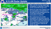
 
For NC, this has been the obvious outcome all along.

915 radar update.png
Problem is you have a raging warm nose between H85 and H7. Sounding in the coldest spot along NC/VA border at 15z Tuesday. Looking like the very definition of a nuisance event with several hours of sleet with temps just above freezing.

View attachment 168087

View attachment 168086
 
I'm surprised Northern NC isn't icing over. Temps are a little colder here than what was predicted. Currently 36 and pouring rain.
 
I'm surprised Northern NC isn't icing over. Temps are a little colder here than what was predicted. Currently 36 and pouring rain.
Hasn’t been a lot of precip there since early morning
 
Back
Top