• Hello, please take a minute to check out our awesome content, contributed by the wonderful members of our community. We hope you'll add your own thoughts and opinions by making a free account!

Wintry Feb. 19-20

I’m all in on school closures. Looking forward to sleeping in until 8 instead 6 tomorrow. Let’s go!

My kids' school is on "remote learning" tomorrow but that involves us as parents taking a bunch of class materials sent to us via email and teaching them as if we're four different teachers tomorrow. Oh and I have my day job too which is based 2000 miles away and doesn't ever "close." What a nightmare.
 
My kids' school is on "remote learning" tomorrow but that involves us as parents taking a bunch of class materials sent to us via email and teaching them as if we're four different teachers tomorrow. Oh and I have my day job too which is based 2000 miles away and doesn't ever "close." What a nightmare.
Sounds like your kids have the stomach bug going around and can’t complete the the assignment
 
Y'all make me realize how fortunate I am not to have school aged kids at home, and be self employed. Spouse is retired twice and sets his own schedule for the work he does now. We are blessed. Winter weather is merely and inconvenience.
 
Y'all make me realize how fortunate I am not to have school aged kids at home, and be self employed. Spouse is retired twice and sets his own schedule for the work he does now. We are blessed. Winter weather is merely and inconvenience.
I tried to mark off due to bad roads tomm but

1. I work from home ....

2. My bosses are in Western PA AND/OR Colorado Springs so they have no sympathy
 
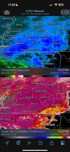
i guess i'm still a little unsure that this gulf convection is this defcon 1 disaster quite yet

hey, want to know something that models struggle with sometimes... mesoscale convective systems. i'm a little hesitant to confidently say, yeah, this thing is gonna spawn a derecho that reaches the southern gulf that cuts off all our moisture

edit- there's also some stupid supercell in the middle of the gulf that not a single CAM has captured. it's been sitting there for 6 hours and the HRRR hasn't acknowledged it
 
IK this isnt some yoked up FireHose of a LP but I thought GCC was reserved for the big juice bombs ? IK 2014 We were all worried and it didnt happen, and I feel like another one I cant remember. But wouldnt it enhance the QPF if it was angled right ?
 
i guess i'm still a little unsure that this gulf convection is this defcon 1 disaster quite yet

hey, want to know something that models struggle with sometimes... mesoscale convective systems. i'm a little hesitant to confidently say, yeah, this thing is gonna spawn a derecho that reaches the southern gulf that cuts off all our moisture

edit- there's also some stupid supercell in the middle of the gulf that not a single CAM has captured. it's been sitting there for 6 hours and the HRRR hasn't acknowledged it
This does feel like a panic we could be laughing at this time tomorrow while the snow falls. Or it may truly be disaster. Somehow, I feel like I am less sure about what’s going to happen with this storm than I’ve been in a week, and it’s starting in under 18 hours (if it starts at all). LOL!
 
This does feel like a panic we could be laughing at this time tomorrow while the snow falls. Or it may truly be disaster. Somehow, I feel like I am less sure about what’s going to happen with this storm than I’ve been in a week, and it’s starting in under 18 hours (if it starts at all). LOL!
i share the sentiment that webb and a lot of these guys have that this has been a total PITA to forecast
 
i share the sentiment that webb and a lot of these guys have that this has been a total PITA to forecast

Yeah the whole thing has just left a bad taste in my mouth here. I mean I'm not really mad at the mets the data was just wrong 🤣 but how and why in this age is frustrating how can like almost every model be so off

The one time we were plenty cold and literally had all day

I will say maybe some of the Mets shouldn't have picked the models with the most snow
 
if you want some real, uncut copium, i got some comparison images for you. showing infrared satellite- in my opinion high clouds are a good proxy indicating upper air divergence.

so far the cloud deck is more expansive and robust than modeled.

COD-GOES-East-regional-southeast.13.20250219.051617-over=map-bars=data.gif
some landmarks here: high clouds
- are almost to the tennessee line
- are past the georgia line
-are clipping the SE corner of arkansas

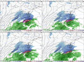
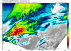
compare CAMs to the same time:
1739942811797.png
RGEM - lifeless
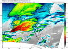
1739942904817.png


3km - a little better, but still lacking cover in MS/AL

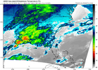
1739943012617.png
HRRR- better with geography, just seems to have issues with initialization

none of these models have even bothered to capture that stupid central gulf supercell

anyway, main point is cloud deck seems a little more vibrant than what models had at this time (and i gave the models a head start... used 6z instead of 5z)
 
32/24, 71% humidity. maintaining hope for a 1-3 inch event, even if there is reason to believe we are heading for total bust
 
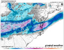
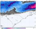
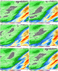
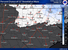
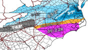
00z EPS is basically identical to the 18z EPS, just slightly west/improved if you squint. 3-4” for Raleigh, 2-3” for Durham, 1-1.5” for CLT and GSO, 2.5-3.5” for RIC, 8”+ for Moyock taking clowns at face value.
 
Back
Top