WolfpackHomer91
Member
Thats all we should be worried about 5 days out.... GFS/EURO/CMC/UK line em up they all are very similar in placement .... Lock that in first then the rest will follow based off Climo of the track historically
Thats all we should be worried about 5 days out.... GFS/EURO/CMC/UK line em up they all are very similar in placement .... Lock that in first then the rest will follow based off Climo of the track historically
Maybe I'm thinking about different time frames but the AI kept painting inches of snow for the upstate and piedmont areas for days, for both Jan storms and it ended up being completely off. I think the AI has been very poor this year. Consistent for days at a time then it seems to make big concessions towards other models late. So consistently bad.Not sure why AI is getting trashed. It’s been good all winter. The CMC was way too amped at this range for thr 1/21 event. This was the AI from day 5-6 to inside day 3.
This was pretty good.
View attachment 169005
You thinking a GFS solution?don't think this will be raleigh's storm, sorry guys
Never was thinking a pure or near-pure snowstorm but hoping more slight-sn to heavy ip and perhaps small glaze of zr as opposed to just a hard zr/rn storm. Are you seeing just a cold rain set up for rdu in the end?don't think this will be raleigh's storm, sorry guys
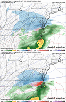
Thanks. I'm curious if the National Blend of Models on Pivotal show Ice amounts? Weatherbell doesn't. I'm afraid we are tracking an ice storm for many.
They do, actually posted those to start the threadThanks. I'm curious if the National Blend of Models on Pivotal show Ice amounts? Weatherbell doesn't. I'm afraid we are tracking an ice storm for many.
In the end, if the progressive models are right, it might be nobody's storm. Still concerned about the progressive solutions.don't think this will be raleigh's storm, sorry guys
It’s ok to be confused. I literally showed you 3 days of model runs of the AI from day 6 and had the general idea correct.Maybe I'm thinking about different time frames but the AI kept painting inches of snow for the upstate and piedmont areas for days, for both Jan storms and it ended up being completely off. I think the AI has been very poor this year. Consistent for days at a time then it seems to make big concessions towards other models late. So consistently bad.
In the end, if the progressive models are right, it might be nobody's storm. Still concerned about the progressive solutions.
I say the 2 camps move toward each other with the blend then climbing north some inside of 48 hoursThis is a pretty good Day 5 battle between the AI models and the regular globals. GFS graphcast, Euro Graphcast, Euro AI, Pangu all are in the same general camp with the handling of the northern low/cut off.
Icon/GFS/Euro/EPS/CMC are all cutting if off much quicker and further West. (EPS is closest to middle ground).
One side has to fold pretty soon.
Yup. Always like a blend of 2 or more disagreeing models. If you do that for our current setup, it’s a slop event for NC outside climo areas, snow-mix for climo areas/mountains snow for mid AtlanticI say the 2 camps move toward each other with the blend then climbing north some inside of 48 hours
ensembles you mean right?I will say this, if the UKMET and EURO agree that has historically been a trough combo to beat
No chance.So we thinking this thing whiffs out to sea?
Icon already looks better lol
It’s definitely better then that pathetic 12z run with the confluence/cold feed on top of us, thank goodness that 12z run didn’t continue its lookICON still going to be fairly amped…it’s one model I don’t give much weight too. The KMA is better.
View attachment 169032

Yea thought about those things a lot past couple days. Also On my mind is with that track, Miller A can make their own Cold/ like a ULL. Tricky , but if you can get it to bomb off SC/GA Coast, not Delmarva, then you'd catch a nice 3 hour backside. Danger is it going haywire on the gulf coast , earlier as WAA will cremate your thermals. Always a fine line. What keeps it so intriguing.One thing that's missing on this map to me, which I'm surprised is not there based on the 50/50 low placement is high pressure center in the NE. Imagine if we could have even a semi-strong high in NY to push the CAD, I think it would be a whole board hit. That low track is great, and by itself I'm surprised it won't snow IMBY.
can you show some more frames previous to that one you posted? wanna see what it shows for MS, AL, and GA folks. Thanks.View attachment 169034
ALRIGHT ALRIGHT
That small tick at 500mb above us =It’s definitely better then that pathetic 12z run with the confluence/cold feed on top of us, thank goodness that 12z run didn’t continue its look View attachment 169033


That small tick at 500mb above us = View attachment 169037View attachment 169038View attachment 169039
I really just rather play along with that confluence in the NE holding back more. Thats the end result we truly need
No storm is ever RDU’s storm, can it just be summer already? This winter has taunted us enough with all these so called winter storms.don't think this will be raleigh's storm, sorry guys
N SC and Central NC clap in unisonView attachment 169034
ALRIGHT ALRIGHT
It’s definitely better then that pathetic 12z run with the confluence/cold feed on top of us, thank goodness that 12z run didn’t continue its look View attachment 169033
