Brandon10
Member
That high pressure to the NW really needed to be situated a tad more east....
That high pressure to the NW really needed to be situated a tad more east....
Pretty much except for the mountains.did HRRR just dry slot the *entirety* of NC save for the NE coast??
Yup.did HRRR just dry slot the *entirety* of NC save for the NE coast??
 ).
).You have to be concerned about everything that doesn’t show snowProbably not much reason to be concerned about the HRRR at this range. It’s terrible, not that it couldn’t be right as a broken clock is right twice a day. It probably would’ve blown up the coastal a bit at the end of its run, but yes as depicted it’s quite bad. Anyways, the 18z NAM is underway (another model we maybe shouldn’t take seriously at this range
yeah youre right - 18z nam 3k looked very similar at that same Wednesday 18z time stamp but then blossomed in the final 6 hours to give a solid 2+ inches for central and northern NC. HRRR mightve been headed in that same direction, and also HRRR certainly isnt the thing we need to pay most attention to right now, but oof nonethelessI think the Hrrr was about to blossom some stuff with the upper level jet... but definitely a worst case scenario in general.
It looks a lot like the 12z 3km NAM.
Cool....Nothing, absolutely NOTHING is showing a shutout in Charlotte unless you live on College street in a condo or something... ANY of the suburbs in play for 2-4" 100%We have some warning shots being fired for sure, enough models whether we trust them or not, are showing suppression and this drying up big time. Granted this is for my area in Charlotte but seems to me the writing is starting to show up on the wall. We've seen this a lot this winter season and no need to think it won't trend the same way with the current modeling.
I hope you are right and maybe I am jaded with how it's played out this year, I am just looking at what we have going right now. You are absolutely correct that is shows it now, hopefully we keep that alive.Cool....Nothing, absolutely NOTHING is showing a shutout in Charlotte unless you live on College street in a condo or something... ANY of the suburbs in play for 2-4" 100%
that’s prob high end. Sleet and ZR will likely keep snow to 0 to 1”.Cool....Nothing, absolutely NOTHING is showing a shutout in Charlotte unless you live on College street in a condo or something... ANY of the suburbs in play for 2-4" 100%
yea maybe Huntersville - Concord - Pill city USA aka Gastonia for sure.... I get @1300m even talking about putting models down, but I really dont understand all these TV guys and Others "ohhh dreaded warm nose all the way to I-40" ok show me? Bc you cant, youre literally just basing it off history ect. I dont mean "you" as in you either Bird lolthat’s prob high end. Sleet and ZR will likely keep snow to 0 to 1”.
It's not good if you want QPFWould that be a big issue for not wanting the system to amp up. Wouldn’t it also limit the warm nose?
Sent from my iPhone using Tapatalk
You are much safer than me mixing wise, you should be fine. I always tow the line being close to 85. My worry is QPF wise, there is not doubt at this point it has trended down some, except the last suite of models.yea maybe Huntersville - Concord - Pill city USA aka Gastonia for sure.... I get @1300m even talking about putting models down, but I really dont understand all these TV guys and Others "ohhh dreaded warm nose all the way to I-40" ok show me? Bc you cant, youre literally just basing it off history ect. I dont mean "you" as in you either Bird lol
EDIT : We will get shutout qpf wise b4 Mixing is an issue... but who am I
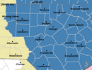
They’re up now.Watches now showing up in NC and Va. RAH NWS holding off.
You want this to become amped and amped and amped again..... if you want QPFWould that be a big issue for not wanting the system to amp up. Wouldn’t it also limit the warm nose?
Sent from my iPhone using Tapatalk
I think you're in good shape for at least an inch or two if you're north/ east of the 77/85 interchange. Being about a mile west of 77 and 5 miles south of 85, I'm living on the edge from the west and south with this one at this point, so I am preparing for disappointment. I do think mixing is going to be an issue in the city at least when precipitation starts falling due to UHI and marginal rates. Seen it too many times to discount. I'm hoping intensity can get heavy and precipitation can last long enough to overcome before it moves eastward. I'm still thinking the ULL can be the bigger deal for those of us to the west if it tracks right.yea maybe Huntersville - Concord - Pill city USA aka Gastonia for sure.... I get @1300m even talking about putting models down, but I really dont understand all these TV guys and Others "ohhh dreaded warm nose all the way to I-40" ok show me? Bc you cant, youre literally just basing it off history ect. I dont mean "you" as in you eoither Bird lol
EDIT : We will get shutout qpf wise b4 Mixing is an issue... but who am I
In central NC that’s not necessarily true. We were dealing with mixing on the 12z Nam. For your area, yes this is trueYou want this to become amped and amped and amped again..... if you want QPF

best guess is that better northern stream interaction pushes this a little on the stronger/warmer sidePersonally, I’d be surprised if the 18z NAM differs from the 12z much in the end. Famous last words.
Yeah, starting to see that as we get into hr 40+. H5 does look a bit better to my lightly trained eye. Seeing a little more precip blossom st the surface at hr 45 than last run, too.best guess is that better northern stream interaction pushes this a little on the stronger/warmer side
Definitely filling in better than last run.


Pretty good spread from RAL
“WHAT...Heavy mixed precipitation possible. Total snow and sleet accumulations between 1 and 6 inches,”
 and the precip is 12 hours away