Webberweather53
Meteorologist
The GFS & NAM were playing catch up for most of the way this winter with the last several cases like this I watched unfold, even over the mid Atlantic and NE US.

Well, the 6z euro is starting to limit the decent moisture to the eastern coastal plain. Quite a dry slot to the west.Definitely feel better here after seeing the EPS and the 06z runs thus far. I'll still be shocked if we don't get the last 24-36 hr NW trend.


EURO AI for the win. Unfortunately,And the EPS to match. Northern stream squash job.
You ain't lying, we are on our way to a wiff if this doesn't reverse course soon but so far no signs of thatWell, the 6z euro is starting to limit the decent moisture to the eastern coastal plain. Quite a dry slot to the west.
View attachment 169935


This reminds me of December 2000 where it shifted east all the way until the event started and ended up being confined to 95 east. Oh wellAnd the EPS to match. Northern stream squash job.

This one?This reminds me of December 2000 where it shifted east all the way until the event started and ended up being confined to 95 east. Oh well

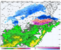
Seems these are usually a few cycles behind. There’s no guidance showing those amounts with that footprint over Virginia right nowLooks like NWS following the NBM fairly closely
View attachment 169942
Yep, that one. 48 hours out it was a foot for Raleigh and it just kept shifting east. Similar setup too.This one?
View attachment 169943

They are only one cycle behind, this one was based off of the 0z model suite, also has some modeling data we do not have access too. And fwiw GFS still did show that snow footprintSeems these are usually a few cycles behind. There’s no guidance showing those amounts with that footprint over Virginia right now


Tbf that snow footprint is aligning with most other modeling, it's just more expansive to the SW. The Rgem isn't too far off from that, problem is all of them are still trending wrong direction
That ULL in 2014 produced some of the heaviest snow I’ve ever witnessed and wasn’t modeled very well until about 24 hours before if I recall. It added an additional 3-6 inches on top of the main event from the day before.I’m quickly becoming interested in this Thursday morning instead.
View attachment 169947
View attachment 169948


Yeah me too. I'm hoping for a Lee side deformation band setting up to our west and giving me a quick inch.I’m quickly becoming interested in this Thursday morning instead.
View attachment 169947
View attachment 169948
Me too. RGEM was ok here too, I guess. The last 48 hours have been tuff to watch.Gotta ride the 6z GFS ( Nothing I despise worse): My last hope. What could possibly go wrong LOL...
View attachment 169950