NBAcentel
Member
Best frame… still pretty to look at but starting to become scary knowing what this could look like tomorrow at this time 
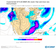
I was about to post this frame. RDU is at 25F on this frame Wednesday evening, pretty beautiful. But yeah the trend is the concern for me at this point.Best frame… still pretty to look at but starting to become scary knowing what this could look like tomorrow at this time View attachment 169917

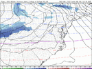
That’s what the mid Atlantic people were saying yesterday. You would think it has to stop but here we are another cycle down and no end in sightOkay, we stop this tonight and gain more QPF starting at 06z right.. View attachment 169918

Being in the bullseye 4 days out has been and will always be the kiss of death. If something doesn’t change soon, this is going to be an I95 East event at best. I’d be sweating bullets if I was in the RDU locale. The trend has been shifting further and further south and east every run and it hasn’t let up yet. I mean the euro is cutting totals in half for everybody every run unless you’re near the coast.I was about to post this frame. RDU is at 25F on this frame Wednesday evening, pretty beautiful. But yeah the trend is for concern for me at this point.
i mean when our lightest green precip hues are now back towards I-95 what’s the point any more. I’d rather lose it entirely. I think that would be more memorable at this pointOkay, we stop this tonight and gain more QPF starting at 06z right.. View attachment 169918

Still gonna stick to thisThats my thinking. Maybe some more lower QPF runs tonight, then we start the other direction tomorrow-Tuesday. Even the gulf mauler had that last second upward QPF trends mainly because models started to recognize the jet streak aloft and were to dry in the low levels. Low levels aren’t gonna be this dry to start out this go around that we have to fight. And the overrunning precip before the main coastal is driven by warm air advection
i agree but jesus the trend with the suppressed heights ahead of the storm needs to relaxStill gonna stick to this

Just to put this in perspective … mby and the northern upstate went from 4-6” to at best a half an inch now. CLT has gone from 5-8” south to north to 1.5”. GSO and Winston Salem has gone from over a foot to 2”. RDU has gone from over a foot to 4-6” mean. And these are getting cut in half every run. Even Wake county has gone from over 1” of QPF to barely 0.5” in about 3 runs. I want to say there should be more QPF back west and maybe we start seeing that come back in the next day and a half but right now the trend is drier and drier every run and it hasn’t slowed down a bit. In fact it’s picking up steam. I’m telling you, if I'm west of 95 right now, I could care less what these models are showing, I’d be sweating like crazy
Oh don’t worry, the way this thing is going, by this time tomorrow you’ll be right there with us having partly cloudy skies and a stiff NW wind lolWhen's the right time?! When I'm making snow angels in 12" on Wednesday night?!
That was the consensus with the best model we have to rely on.Are you basing these totals on just one particular model?
on euro alone i've gone from 20 inches of snow to 3Just to put this in perspective … mby and the northern upstate went from 4-6” to at best a half an inch now. CLT has gone from 5-8” south to north to 1.5”. GSO and Winston Salem has gone from over a foot to 2”. RDU has gone from over a foot to 4-6” mean. And these are getting cut in half every run. Even Wake county has gone from over 1” of QPF to barely 0.5” in about 3 runs. I want to say there should be more QPF back west and maybe we start seeing that come back in the next day and a half but right now the trend is drier and drier every run and it hasn’t slowed down a bit. In fact it’s picking up steam. I’m telling you, if I'm west of 95 right now, I could care less what these models are showing, I’d be sweating like crazy

the problem is it’s now just a coastal and those can only get moisture back so far west on a good day. CLT maybe if the stars align but even that is a mega reach. We need this thing to be what it was a couple days ago. It’s a totally different storm now unless we perform a miracle with the intial overrunning before the transfer. Which we won’tJust to put this in perspective … mby and the northern upstate went from 4-6” to at best a half an inch now. CLT has gone from 5-8” south to north to 1.5”. GSO and Winston Salem has gone from over a foot to 2”. RDU has gone from over a foot to 4-6” mean. And these are getting cut in half every run. Even Wake county has gone from over 1” of QPF to barely 0.5” in about 3 runs. I want to say there should be more QPF back west and maybe we start seeing that come back in the next day and a half but right now the trend is drier and drier every run and it hasn’t slowed down a bit. In fact it’s picking up steam. I’m telling you, if I'm west of 95 right now, I could care less what these models are showing, I’d be sweating like crazy


Can’t lose any more ground. If we can erase the 00z damage by 12z tomorrow we may be able to salvage something1” probs and final mean View attachment 169924View attachment 169925
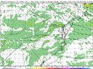
i find it really interesting qpf actually nudged up east of highway 1
Note that last frame doesn’t cover the full storm for NC/SC/VA.i find it really interesting qpf actually nudged up east of highway 1
I could be totally wrong but maybe that suggests that the further south and east trend is beginning to take a pause and come back NW a small bit?i find it really interesting qpf actually nudged up east of highway 1


06z RGEM
Sent from my iPhone using Tapatalk

Be nice if that back end really did fill in like that Wednesday night Thursday morning. It might just save us all back in western part of the state.
06z RGEM
Sent from my iPhone using Tapatalk