Cary_Snow95
Member
We’ve all seen the NAM hold onto a solution opposite the consensus. And then around 48 hours it will have whole sale changes to meet consensus
People like JB and some Mets in the mid Atlantic say the H5 pattern with the confluence or whatever doesn’t match typical misses to the south with analogs suggesting more NW. more like a Fredericksburg jackpot. These are Mets and so are you, two camps saying different things so what is the truth?The long range NAM being that far north & given its performance this season in these setups w/ big chunks of the polar vortex getting trapped underneath a blocking high, says a lot about the chances of that solution verifying (slim to none).
What’s you current thinking on the system and potential trends?The long range NAM being that far north & given its performance this season in these setups w/ big chunks of the polar vortex getting trapped underneath a blocking high, says a lot about the chances of that solution verifying (slim to none).
People like JB and some Mets in the mid Atlantic say the H5 pattern with the confluence or whatever doesn’t match typical misses to the south with analogs suggesting more NW. more like a Fredericksburg jackpot. These are Mets and so are you, two camps saying different things so what is the truth?
People like JB and some Mets in the mid Atlantic say the H5 pattern with the confluence or whatever doesn’t match typical misses to the south with analogs suggesting more NW. more like a Fredericksburg jackpot. These are Mets and so are you, two camps saying different things so what is the truth?
I'm going with EricPeople like JB and some Mets in the mid Atlantic say the H5 pattern with the confluence or whatever doesn’t match typical misses to the south with analogs suggesting more NW. more like a Fredericksburg jackpot. These are Mets and so are you, two camps saying different things so what is the truth?
I do expect the NAM to fall a little more in line with everything else but when it starts suggesting thermal issues I prefer to bite early. It makes life easier 60 hours from nowPeople like JB and some Mets in the mid Atlantic say the H5 pattern with the confluence or whatever doesn’t match typical misses to the south with analogs suggesting more NW. more like a Fredericksburg jackpot. These are Mets and so are you, two camps saying different things so what is the truth?
When it comes to NC winter storms I definitely put more weight into what Webber says than any other meteorologistI'm going with Eric
Sent from my SM-S156V using Tapatalk
What’s you current thinking on the system and potential trends?
Is that high being modeled too strong? I remember during the Jan storm we had similar highs showing up and everyone said they would verify weaker , did it? I know the end result was the same though with storm on the gulf
Icon is annoying and says freezing rain in RaleighIcon holds pretty steady.
View attachment 169713


Had to because look at this:
That track never makes the gulf coast where it can tap into additional moisture and really up the QPF levels before exiting and starting its run up the east coast. With a inland track like that most of us get screwed. Let's keep the NAM on its own island and keep the other models away from this solution.This still a Miller A track? Asking for Lick. 12z had it transferring from south GA off the coast of Charleston. Now it goes Macon to Florence to North MyrtleView attachment 169704
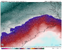
Well, they got one thing right at least. That dividing line between snow and ice is practically right over my house and I've seen too many winter events where that is the case.
I was one of the receipents of that 2" total near McCullers that you mention LOL. Even though two inches would be OK I want to see some bigger numbers this time.Given the amplitude of the wave & warmer mid Feb background climo temps aloft, this storm is probably gonna be up there in terms of big local snow/sleet accumulation gradients across north-central NC.
Once we get the details narrowed down, this feels like it will be a near impossible forecast for those near the snow/sleet line as the difference between a couple inches of sleet & a foot of snow could be as little as 20-30 miles and maybe 1F aloft near the warm nose.
The pattern isn't the same of course, but in that Feb 1989 event, 2" of snow fell in McCullers, while 15" occurred in Butner/southern Granville County. That's the kind of thing that this storm is capable of doing, we obviously don't know where said gradient will setup yet.
