-
Hello, please take a minute to check out our awesome content, contributed by the wonderful members of our community. We hope you'll add your own thoughts and opinions by making a free account!
You are using an out of date browser. It may not display this or other websites correctly.
You should upgrade or use an alternative browser.
You should upgrade or use an alternative browser.
Inside D6 trend strikes again proving why it is so unwise to bank on anything D6+ modeling is showing. If you've followed this one for more than a week, you've basically tracked two storms: the fantasy one and now the real one slowly coming into focus. It's hard to let go of some of those things seen out at range, but the reality is there is only so much amping up this one can do for western parts at this range.
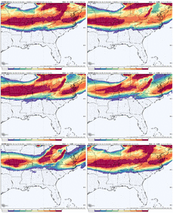
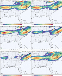
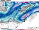
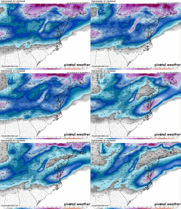
EPS members starting to come to a consensus minus a few holdouts. Real question is where does the axis of heaviest precip line up and of course, ptypes.
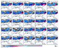
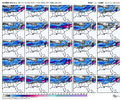


EPS members starting to come to a consensus minus a few holdouts. Real question is where does the axis of heaviest precip line up and of course, ptypes.


Do you know what precip amount the color shades indicate, by chance? Either way, the shift is clear. Don’t hate it for MBY. I’d assume it’s colder, too?6z vs 12z AI View attachment 169681
It will come back westInside D6 trend strikes again proving why it is so unwise to bank on anything D6+ modeling is showing. If you've followed this one for more than a week, you've basically tracked two storms: the fantasy one and now the real one slowly coming into focus. It's hard to let go of some of those things seen out at range, but the reality is there is only so much amping up this one can do for western parts at this range.
View attachment 169680View attachment 169679
EPS members starting to come to a consensus minus a few holdouts. Real question is where does the axis of heaviest precip line up and of course, ptypes.
View attachment 169683
View attachment 169684
Cad Wedge NC
Member
Oh, who are we kidding, we all know this will trend west at the last minute. Question is how much. Just wait until the NAM gets in its wheelhouse, that will tell us all we want to know. I just want to keep the same thermals when this west trend is done.I’d give it until 0z tomorrow night. It won’t take much to get the tail end of the storm to amp and move up the coast.
Mahomeless
Member
Really starting to dry out for a lot of people. H85 trends are squashing this thing to death.
NBAcentel
Member
Has the energy even come ashore yet for this storm?
- Joined
- Jan 23, 2021
- Messages
- 4,602
- Reaction score
- 15,197
- Location
- Lebanon Township, Durham County NC
The euro being the wettest model is a good sign.
rburrel2
Member
What's funny is it feels like this storm has trended perfectly for Raleigh, NC, at the expense of just about every other location.
NAM tracks it from Jackson MS to Montgomery AL to Albany GA then transfers it off the coast of Charleston. lol but everyone has picked a hill to die on already and that’s ok. It’s why we do thisOh, who are we kidding, we all know this will trend west at the last minute. Question is how much. Just wait until the NAM gets in its wheelhouse, that will tell us all we want to know. I just want to keep the same thermals when this west trend is done.
jmorris
Member
Also have the UK and Canadian not far off from the Euro. GFS is the only one still holding back. I think it looks good for the Triangle at this moment.The euro being the wettest model is a good sign.
- Joined
- Jan 23, 2021
- Messages
- 4,602
- Reaction score
- 15,197
- Location
- Lebanon Township, Durham County NC
WolfpackHomer91
Member
What’s hilarious and it happened both storms this year…. Forum says trending down….. turn on tv or Twitter Local Mets say going up. If you weren’t on a forum or looking for yourself and just follow Mets I’d be hyped right now. A few that never post anything are excited for this one on Twitter lol
Sent from my iPhone using Tapatalk
Sent from my iPhone using Tapatalk
There are many members that bring a nice little snow to North Alabama. Keep the SE trend rolling!Inside D6 trend strikes again proving why it is so unwise to bank on anything D6+ modeling is showing. If you've followed this one for more than a week, you've basically tracked two storms: the fantasy one and now the real one slowly coming into focus. It's hard to let go of some of those things seen out at range, but the reality is there is only so much amping up this one can do for western parts at this range.
View attachment 169680View attachment 169679
EPS members starting to come to a consensus minus a few holdouts. Real question is where does the axis of heaviest precip line up and of course, ptypes.
View attachment 169683
View attachment 169684
You backing off of the 1-3 inch prediction for upstate?What's funny is it feels like this storm has trended perfectly for Raleigh, NC, at the expense of just about every other location.
WolfpackHomer91
Member
No accumulation talk yet ….90%

High of 36 Weds? Hmmm umm nooo chance
Sent from my iPhone using Tapatalk
SnowNiner
Member
Well, catching up from last night, it seems like the drying up trends unfortunately continued, and may not be over yet. Pretty bummed the Euro and the EPS has dried up and caved to the AIs. I guess they win another one here.
Grit tried to warn us a while ago that the more confluence we get, the weaker the storm may be, and that's pretty much the situation I think. The monster -AO, and significant cold is making the southern energy weaker (until it gets in the ocean). Too much of a good thing I guess, again. It's actually too cold for the CLT area to snow this winter.
I don't buy into the more precip NW than modeled discussion, at least that will matter for mby. Reality for me is this is a Raleigh and NE storm, and perhaps an advisory event for MBY and west. We'll see. I'll take a couple of inches if I can get it, but I'd be shocked if I get more than 1 or 2 inches out of this at this point. I actually miss the runs where I was getting a couple inches of sleet and ZR. smh.
Tsappfrog20
Member
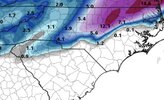
Pretty good look from the NWS Raleigh for Youngsville. Totals about 5.5 inches of snow with some sleet.

Sent from my iPhone using Tapatalk

Sent from my iPhone using Tapatalk
Mpirone12
Member
Something that has not been mentioned yet is ground temps are not nearly as cold as last storm so it may take a little bit to start sticking. Shouldn’t be that bad though since temps have gone back and forth all week.
That, and the diurnal timing aren’t ideal, but that’s why the fact BL temps will be in the low to mid 20s for many AND rates will likely be heavy really helps us out in that regard. If we were talking light rates with temps around freezing, I’d be more worried we’d waste a lot of snow getting it to stick. Either way, it is something to consider, though. Too bad we couldn’t get this in mid-January!Something that has not been mentioned yet is ground temps are not nearly as cold as last storm so it may take a little bit to start sticking. Shouldn’t be that bad though since temps have gone back and forth all week.
EDIT: @1300m posted the forecasted soil temps and they’re actually <40 for a lot of us, so not as much of a factor as I expected. I was afraid they’d be in the 45-50 range.
Last edited:
rburrel2
Member
Nah I still think that’s the most reasonable guess right nowYou backing off of the 1-3 inch prediction for upstate?
I for one appreciate your analysis. Looking at the frames on this latest Euro model run there are a few members that show nothing for lots of folks in western and central North Carolina. If this keeps shifting to the south and east and flattens out even more then there will be more disappointed folks who are expecting a significant snow. Let's hope things trend more amped and to the northwest a little more.Inside D6 trend strikes again proving why it is so unwise to bank on anything D6+ modeling is showing. If you've followed this one for more than a week, you've basically tracked two storms: the fantasy one and now the real one slowly coming into focus. It's hard to let go of some of those things seen out at range, but the reality is there is only so much amping up this one can do for western parts at this range.
View attachment 169680View attachment 169679
EPS members starting to come to a consensus minus a few holdouts. Real question is where does the axis of heaviest precip line up and of course, ptypes.
View attachment 169683
View attachment 169684
Soil temps should not be a major inhibitor to accumulation. NWS RAH conducted research and found that soil temperatures < 40F had little to no effect on snowfall accumulation in the presence of cold temperatures. With temps falling into the 20s, if there are good rates snow will pile up. Roads may stay wet a little longer compared to earlier events, but grassy and elevated surfaces should do well.Something that has not been mentioned yet is ground temps are not nearly as cold as last storm so it may take a little bit to start sticking. Shouldn’t be that bad though since temps have gone back and forth all week.
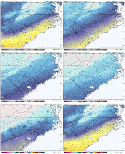
Man Raleigh has been just dunking on Charlotte over the years. Goodness..
No, both cities have struggled mightily in the snow department in the past 5 years or moreMan Raleigh has been just dunking on Charlotte over the years. Goodness..
Sure. But Raleigh has scored better with moderate to major systems. 2018 Dec was a prime example. A storm that should have worked out much better for Charlotte.No, both cities have struggled mightily in the snow department in the past 5 years or more
SnowNiner
Member
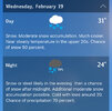
No accumulation talk yet ….90%
High of 36 Weds? Hmmm umm nooo chance
Sent from my iPhone using Tapatalk
The term "showers" is the key here. Snow, and Snow Showers are two different things. Intermittent periods of snow showers is what we're forecasted for currently, not continuous snow.
olhausen
Member
iwantsouthernsnow123
Member
Now we just need Upstate SC and NE Georgia to get in on the actionSure. But Raleigh has scored better with moderate to major systems. 2018 Dec was a prime example. A storm that should have worked out much better for Charlotte.
Pulling hard for yall! Hope we can fill in that snow gapNow we just need Upstate SC and NE Georgia to get in on the action
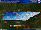
Surprised with how quiet the TN/northern MS/AL/GA crew has been the last several days. One would think that nothing at all is going on over here lol. Overall setup is good for a potential light to moderate snowfall event for Memphis, Nashville, Knoxville, Huntsville, and Chattanooga. The northern burbs of Birmingham and Atlanta can't be ruled out either. Less precip to work with for those of us west of the Apps, but, timing is pointing to a mainly overnight/morning event which is definitely preferable for mid-February.
I am done wish casting this one. I know the chances of a big NW trend are low at this point. I do believe eastern NC and SE VA are good to go
If you go back to January 2000, then yes. Raleigh gets some benefit of the Atlantic moisture that Charlotte does not, therefore the 2 inch higher average. The past 10 years, just north of Raleigh has scored, like in 2018, but otherwise snow drought here as well.Sure. But Raleigh has scored better with moderate to major systems. 2018 Dec was a prime example. A storm that should have worked out much better for Charlotte.
Pops
Member
Oh we here!!just waiting for a few more model runs before we get excitedSurprised with how quiet the TN/northern MS/AL/GA crew has been the last several days. One would think that nothing at all is going on over here lol. Overall setup is good for a potential light to moderate snowfall event for Memphis, Nashville, Knoxville, Huntsville, and Chattanooga. The northern burbs of Birmingham and Atlanta can't be ruled out either. Less precip to work with for those of us west of the Apps, but, timing is pointing to a mainly overnight/morning event which is definitely preferable for mid-February.
iwantsouthernsnow123
Member
Gonna be pulling it close... We're really threading the needle with itSurprised with how quiet the TN/northern MS/AL/GA crew has been the last several days. One would think that nothing at all is going on over here lol. Overall setup is good for a potential light to moderate snowfall event for Memphis, Nashville, Knoxville, Huntsville, and Chattanooga. The northern burbs of Birmingham and Atlanta can't be ruled out either. Less precip to work with for those of us west of the Apps, but, timing is pointing to a mainly overnight/morning event which is definitely preferable for mid-February.
interestedclimatist
Member
I bet you’re happy then for this systemIf you go back to January 2000, then yes. Raleigh gets some benefit of the Atlantic moisture that Charlotte does not, therefore the 2 inch higher average. The past 10 years, just north of Raleigh has scored, like in 2018, but otherwise snow drought here as well.
Snowlover34
Member
Yeah i’ve been tracking it but I’m not to excited about it pretty much. actually here in north Alabama near the Tennessee state line local stations here in Hazel Green haven’t been talking about it to muchSurprised with how quiet the TN/northern MS/AL/GA crew has been the last several days. One would think that nothing at all is going on over here lol. Overall setup is good for a potential light to moderate snowfall event for Memphis, Nashville, Knoxville, Huntsville, and Chattanooga. The northern burbs of Birmingham and Atlanta can't be ruled out either. Less precip to work with for those of us west of the Apps, but, timing is pointing to a mainly overnight/morning event which is definitely preferable for mid-February.

