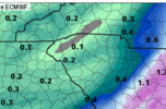
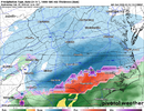
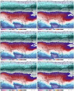
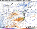
it isnt over for Central NC and central VA at all...?Well I guess enjoy the big storm for far south east VA and ne NC. This one is done for western NC, western VA and Central VA and NC.
-
Hello, please take a minute to check out our awesome content, contributed by the wonderful members of our community. We hope you'll add your own thoughts and opinions by making a free account!
You are using an out of date browser. It may not display this or other websites correctly.
You should upgrade or use an alternative browser.
You should upgrade or use an alternative browser.
a lot of you are posting like the modeling consensus didn't have wilmington getting shutout during the coastal a few weeks ago at this range
Yeah, people are acting like this is locked in...it's obviously not. The same people who are declaring the storm is over will be posting photos of their 6" of snow in a few days, SMH. It won't take many changes to change this one way or the other. It's kind of funny people are melting down who are still seeing 2"+ of snow on a lot of these models. Not every storm can be a big dog.
rburrel2
Member
LickWx
Member
Yeah they have been the big winners the last 4-5 years . 2018, those storms in the early 2020s and now this! I don’t see this stopping trending SE at this point, it’ll probably keep trending SE until verification , that’s been the trend, haven’t seen a NW trending storm in a while so I’m leaning that this one keeps going SEThe trend is not our friend for us. Eastern NC storm is i've been saying for the last 3 days
LickWx
Member
That’s what the mid Atlantic folks said yesterday but now their 2 inches have turned to zero, this keeps zooming SE, what’s stopping it from keeping going?Yeah, people are acting like this is locked in...it's obviously not. The same people who are declaring the storm is over will be posting photos of their 6" of snow in a few days, SMH. It won't take many changes to change this one way or the other. It's kind of funny people are melting down who are still seeing 2"+ of snow on a lot of these models. Not every storm can be a big dog.
yup not sure where the "it's over for all of NC and VA except the coast" rhetoric is coming from; the *majority* of both those states are still in it to get an inch or two even in the lower accum. areasYeah, people are acting like this is locked in...it's obviously not. The same people who are declaring the storm is over will be posting photos of their 6" of snow in a few days, SMH. It won't take many changes to change this one way or the other. It's kind of funny people are melting down who are still seeing 2"+ of snow on a lot of these models. Not every storm can be a big dog.
NBAcentel
Member
WolfpackHomer91
Member
Yeah, people are acting like this is locked in...it's obviously not. The same people who are declaring the storm is over will be posting photos of their 6" of snow in a few days, SMH. It won't take many changes to change this one way or the other. It's kind of funny people are melting down who are still seeing 2"+ of snow on a lot of these models. Not every storm can be a big dog.
I will scream
100x that EURO run for outputs yesterday was WORST thing that could’ve happen to the board imo
Sent from my iPhone using Tapatalk
honestly, if CLT wins big on this one, im gonna be so happy for yall. yeah the triangle didnt get MUCH with either january storm, but yall were absolutely screwed big time. pulling for you!!This is hot View attachment 169649
Wrong wrong wrong!Just need a 25-50 mile swing back west, to get in the real heavy goods. Got the snow sounding and really in a good spot.
Just a 1 hour earlier deepening of the wave,40 mile shift in track, 2 mb deeper etc several ways to accomplish 72 hours out
If you are Lynchburg and west in VA it is. A paltry 2 or 3 inches lolit isnt over for Central NC and central VA at all...?
SWVAwxfan
Member
Where's the SE ridge when you need ut?Well I guess enjoy the big storm for far south east VA and ne NC. This one is done for western NC, western VA and Central VA and NC.
interestedclimatist
Member
LMAO this post is so funny..Well I guess enjoy the big storm for far south east VA and ne NC. This one is done for western NC, western VA and Central VA and NC.
SWVAwxfan
Member
What's happened to the classic storns that tracked from the gulf up the coast? Seems that coastal areas have been getting so much more than western areas in recent years.Wrong wrong wrong!Every back yard for it's self, and mine wants 75-100 mile shift NW
Mpirone12
Member
I’ve been lurking for years. Some of yall are funny. Most models paint 3-5 inches across C NC and according to some “it’s over”. EUROS 10+” was likely never to verify
That’s what the mid Atlantic folks said yesterday but now their 2 inches have turned to zero, this keeps zooming SE, what’s stopping it from keeping going?
In a sense, nothing, but we've still got some wiggle room in that regard. Also, this is starting to get into short range now, so future changes will likely trend towards being less drastic (of course, no guarantees on that, but generally they would be since modeling is most accurate at shorter leads).
NBAcentel
Member
We say in the long range, we gotta cold to snow. Still applies here in nearly the short rangeImpressive.
View attachment 169650
as a snow lover in central NC watching today's runs come in, i am positively baffled at some folks calling it "over" for our region. if i get 3 or 4 inches out of this, im gonna be a HAPPY CAMPERI’ve been lurking for years. Some of yall are funny. Most models paint 3-5 inches across C NC and according to some “it’s over”. EUROS 10+” was likely never to verify
Well we don't get crap here in the mountains anymore. It is the truth. Have not had a good snow since 2018.LMAO this post is so funny..
interestedclimatist
Member
LMAO REALas a snow lover in central NC watching today's runs come in, i am positively baffled at some folks calling it "over" for our region. if i get 3 or 4 inches out of this, im gonna be a HAPPY CAMPER
Take it to the complaining thread, thanksIf you are Lynchburg and west in VA it is. A paltry 2 or 3 inches lol
See you in 36 hours. You can console the minions that get 33 rain after the NW shiftWell I guess enjoy the big storm for far south east VA and ne NC. This one is done for western NC, western VA and Central VA and NC.
interestedclimatist
Member
You said central NC and VA…that’s where all the precip is supposed to fallWell we don't get crap here in the mountains anymore. It is the truth. Have not had a good snow since 2018.
"what is stopping this from continuing to trend southeast" i've seen this so many times before north/stronger trends get going immediately lolThat’s what the mid Atlantic folks said yesterday but now their 2 inches have turned to zero, this keeps zooming SE, what’s stopping it from keeping going?
rburrel2
Member
Euro lines up nicely with the ukmet for thermal profiles. Nice 1-3 coming for the upstate, 3-6 for Charlotte, and 4-8 for Raleigh.
Mpirone12
Member
Let’s not forget the last storm pulled a heroic NW trend to even get Central NC into the mix
Same crowd will be needing counseling on here by Monday Night as the NW shift was to mucha lot of you are posting like the modeling consensus didn't have wilmington getting shutout during the coastal a few weeks ago at this range
Need that heavy precipitation about 100-150 miles further West or a stronger low pressure.You said central NC and VA…that’s where all the precip is supposed to fall
interestedclimatist
Member
I’m just wondering how quick the northward turn will occur and how deep the system will dig. I think the track is pretty solid for now"what is stopping this from continuing to trend southeast" i've seen this so many times before north/stronger trends get going immediately lol
We were bone dry west of Myrtle 36 hours out lol, people have short memoriesLet’s not forget the last storm pulled a heroic NW trend to even get Central NC into the mix
NBAcentel
Member
The NW trend used to be a thing but this year it has been SE trend. Where is that SE Ridge when you need it. The cold press is too much once again.Yeah they have been the big winners the last 4-5 years . 2018, those storms in the early 2020s and now this! I don’t see this stopping trending SE at this point, it’ll probably keep trending SE until verification , that’s been the trend, haven’t seen a NW trending storm in a while so I’m leaning that this one keeps going SE
lol, You can't give up until Tuesday. 

interestedclimatist
Member
Concerning bc I don’t want iceI’d even take another shift south like that, especially with this look View attachment 169651
iwantsouthernsnow123
Member
Recently we've struggled to get this to happen, I've learned over the last 3 years to never believe in systems like this. But ig we'll see. I was surprised to see 12z trends this afternoon.Now see that’s how the CAD normally works. You can see the storm hitting NE Georgia and Upstate SC and the blue starts showing up. That’s how I would expect it look but the models haven’t been showing that really.
Yep alwaysSame crowd will be needing counseling on here by Monday Night as the NW shift was to much
I'd be lying if I said I'm not worried about this being a real scenario in the Lee of the mountains as always.
What is positive imo is it's been wet now for a week or so.
Patterns repeat.
Hopefully this will trend a lil wetter as we get closer.
Hell who I'm I kidding,
Hoping it trends as wet as the Niagara falls so long as the thermals stays what the cold modeling is showing!
No it's not. Stop itCongrats NE NC. This one is over for western nc
lol, You can't give up until Tuesday.
He’s scratching his head. So he’s saying this would be a highly anomolous outcome to what historically is a I-95 blizzard. Bet the streak.


