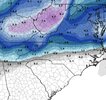
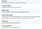
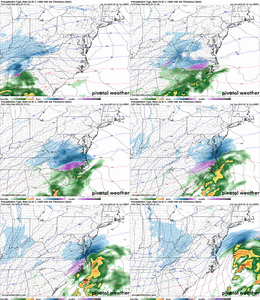
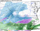
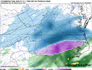
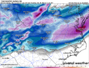
This look just looks odd. Just not a traditional CAD look. Mentioned it earlier. Most model guidance showing this too.
-
Hello, please take a minute to check out our awesome content, contributed by the wonderful members of our community. We hope you'll add your own thoughts and opinions by making a free account!
You are using an out of date browser. It may not display this or other websites correctly.
You should upgrade or use an alternative browser.
You should upgrade or use an alternative browser.
belowfreezing
Member
Just seems today's models are not impressive, and this one is fading some. But certainly, a long way to go. With the amount of cold it may not take much to have major impacts across NC. Hope WOW is right, and we get a NW shift like the past.
Fixed.Raleigh is the snow hole capital of the world

iwantsouthernsnow123
Member
Would this be a good scenerio for NE Georgia, overall?If you’re wondering why the storm is a late bloomer, here on the Euro you can see how the positive-tilt and broad-based southern stream wave over the 4 corners sharpens and turns negative tilt as it treks east into the SE states, with some weak phasing from the northern stream diving in
View attachment 169510
Also, the jet streak over the Mid-Atlantic re-strengthens with curvature, with the lower Mid-Atlantic and Carolinas in the right entrance region of the jet streak (upper level divergence promoting lift).
Now to get more modeling on board
View attachment 169511
The trends are not our friend. This looked great 48 hours ago for nearly everyone. Now not so much.
That is correct. I know you weren't arguing.I thought only Miller B’s Transferred over Upstate / 77 to Coast like this? Miller A’s I thought were one solidified Low That just moved NE up the coast? Honestly asking not disputing.
Sent from my iPhone using Tapatalk
Not sure what’s changed…the 0z euro this morning was epic. Every other model mostly the same today.The trends are not our friend. This looked great 48 hours ago for nearly everyone. Now not so much.
Know your climo—always ask what usually happens in your neck of the woods with this type of setup? That helps with keeping expectations in check one way or the other.
jmorris
Member
Even though it is the least impressive compared to the Euro and GFS, the warm nose on the GFS continues to erode a little each run, too.Well we know the GFS is probably a little too weak and east at day 3-4.
Past few runs.
View attachment 169623
*puts on my SNE snow weenie troll hat*I'm 10 miles west of Corolla, NC and can't believe we have consistency in models giving us 12"+ of snow in 96 hours while it is pouring rain and 60 degrees out right now.
"you guys are STEALING our RIGHTFUL snow further west!! You dont deserve it! Give it back!!"
(I've genuinely seen people from further north say ---- like this to people in VA and NC over this storm lol)
I think we’re stuck between overrunning/miller A/coastal redevelopment/upsloping west/downsloping eastKnow your climo—always ask what usually happens in your neck of the woods with this type of setup? That helps with keeping expectations in check one way or the other.
It really is a mess and no matter how many analogs we think we have they all tend to come to fruition differently.
packfan98
Moderator
Look
a lot of us are now on the nw edge of accumulating snow 3 days out. I’ve been in this position before and end up with sleet and freezing rain with the snow to our north. We shall see.Not sure what’s changed…the 0z euro this morning was epic. Every other model mostly the same today.
Pilotwx
Member
Foothills area, I have been around awhile 25 plus years on weather boards. One of the first was CSI, Dr dew Point and my first introduction to Joe B. Took classes at AppState when they did offer them. Seen many storms .
Miller B’s rarely work out for our area unless some hybrid type system. NW winds dry our area out and moisture jumps to the east of us unless we see a system round the base of the Apps then jump as moisture is allowed to ride /funnels up the Appalachian mountain chain.
Miller A’s for us has to a moisture transport from Texas to LA coast line’s Houston , Brownsville being the best spot longer transport. Low Track off Myrtle Beach /Will area then up the coast. This doesn’t mean that all foothill’s regions get max snow, some will still be rain . But this gives us our max potential as moisture transport is directed right at us.
There are always outliers like amped clippers or cutoffs or coastal the bend back west . But also High pressure needs to be funneling cold air down East side of Apps, Cad .
What has been happening the last few years is NW winds are drying us out , not just snow but rain as well. It may be just me but seems like we are in a drought / or flooding no in between.
This system as of latest model run has CAD setup moisture transport look to be ultimate problem . Looking as well that the cold air is pushing farther South and east quicker helping dry up moisture and having a more NW flow
85This is all that's keeping this area from being all snow on the 06z Euro. Every other layer is below freezing. And this area stays around 1C at 850mb for like the entire storm.
Edited to add: There's probably a stronger push of warm air around 800mb around Raleigh later on in the storm. (but maybe not, I don't have sounding data).
This is all that's keeping this area from being all snow on the 06z Euro. Every other layer is below freezing. And this area stays around 1C at 850mb for like the entire storm.
Edited to add: There's probably a stronger push of warm air around 800mb around Raleigh later on in the storm. (but maybe not, I don't have sounding data).
View attachment 169557
Who would've thought?
mx3gsr92
Member
*puts on my SNE snow weenie troll hat*
"you guys are STEALING our RIGHTFUL snow further west!! You dont deserve it! Give it back!!"
(I've genuinely seen people from further north say ---- like this to people in VA and NC over this storm lol)
If I had it my way, everyone would get snow!
I get it….but If I could be on the NW edge of every potential event at day 3 I would have 10x more snow over the past 20 years.Look
a lot of us are now on the nw edge of accumulating snow 3 days out. I’ve been in this position before and end up with sleet and freezing rain with the snow to our north. We shall see.
I would trade places with you.
interestedclimatist
Member
Ok so, are we getting an ice or sleet storm central nc? Or are we getting just rain
Ok so cold rain. Got it.Know your climo—always ask what usually happens in your neck of the woods with this type of setup? That helps with keeping expectations in check one way or the other.
WolfpackHomer91
Member
*puts on my SNE snow weenie troll hat*
"you guys are STEALING our RIGHTFUL snow further west!! You dont deserve it! Give it back!!"
(I've genuinely seen people from further north say ---- like this to people in VA and NC over this storm lol)
It’s nothing personal …. But it’s like watching a 8-9 seed make a SW 16. Yea 77 corridor is no one seed Climo wise …. But we should be making more sweet 16s than you out there and past 3 yrs we just aren’t lol. Like we’re not that much better, but SHOULD have a higher floor than NE NC. We just don’t for now that’s all. Frosty and Foothills are like that school that used to dominate but NIL hit and they’re stuck in that 4/5 seed range every year. Think KY/UCLA is ect…. Every year they’re “Back” and it just never happens anymore in the End
Sent from my iPhone using Tapatalk
Last edited:
Jessy89
Member

Alright this is just for snow. I did it in 3 zones.
Zone A
2-5 inches of snow best chance of being mostly snow. Remember it’s a first call this can go up.
Zone B
2-4 inches should be common.
Zone C
Is the biggest potential bust zone. Precipitation should start Wednesday morning. 38-40 degrees we have to wetbulb down to 31-33 mark before moisture shuts down in the afternoon. We will lose accumulation do to melting Dusting to 2 inches few areas east into Greenville Spartanburg counties could see 2-3 in isolated spots
I don’t normally do these but I took a stab at it
Sent from my iPhone using Tapatalk
oh well im in the triangle haha, we havent gotten much at all -- and climo wise, i wouldnt say CLT should be getting more than the northern parts of the triangle like where im at. what i do know is, we should BOTH be getting more than we have these past few years!It’s nothing personal …. But it’s like watching a 8-9 seed make a SW 16. Yea 77 corridor is no one seed Climo wise …. But we should be making more sweet 16s than you out there and past 3 yrs we just aren’t lol. Like we’re not that much better, but SHOULD have a higher floor than NE NC. We just don’t for now that’s all
Sent from my iPhone using Tapatalk
Climo wise 20 miles to the west gets more snow due to upsloping. Downsloping for my area typically but that is with Miller Bs or Clippers. Miller A and Southern sliders do alright without that issue. The models keep showing the moisture drying up as it hits the blue ridge and reforming to the east which idk If that makes much sense with this setup unless it is overrunning rather than deep gulf moisture.
Any Metwannabe sightings? He can tell you what seed his northeastern NC neck of the woods has been.oh well im in the triangle haha, we havent gotten much at all -- and climo wise, i wouldnt say CLT should be getting more than the northern parts of the triangle like where im at. what i do know is, we should BOTH be getting more than we have these past few years!
WolfpackHomer91
Member
oh well im in the triangle haha, we havent gotten much at all -- and climo wise, i wouldnt say CLT should be getting more than the northern parts of the triangle like where im at. what i do know is, we should BOTH be getting more than we have these past few years!
No, CLT proper really never gets anything more than 1-2”. It’s seemed anyway , but 40 miles away , Troutman , Salisbury , Hickory , Statesville used to be areas I wanted to move to as a kid bc I lived in Cabarrus county and watched them score while I rained, over…. And over…. And over lol
Sent from my iPhone using Tapatalk
interestedclimatist
Member
Solid little hit of snow off ukmet.
It’s nothing personal …. But it’s like watching a 8-9 seed make a SW 16. Yea 77 corridor is no one seed Climo wise …. But we should be making more sweet 16s than you out there and past 3 yrs we just aren’t lol. Like we’re not that much better, but SHOULD have a higher floor than NE NC. We just don’t for now that’s all. Frosty and Foothills are like that school that used to dominate but NIL hit and they’re stuck in that 4/5 seed range every year. Think KY/UCLA is ect…. Every year they’re “Back” and it just never happens anymore in the End
Sent from my iPhone using Tapatalk
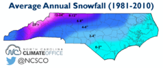
I mean, honestly, the foothills don't average that much more snow than most of the rest of us. Where I am at averages about the same as the southern foothills, for example.
I am having a hard time believing that the coasts of VA and NC are the bullseye for heavy snow 
jmorris
Member
They going for it 90% chance of snow Wednesday then nighttime Freezing rain and sleet altho it depends on where it sets upOk, we have a new type up from the NWS (For Raleigh). Here’s what they are saying:View attachment 169629
Sent from my SM-S156V using Tapatalk
NBAcentel
Member
LukeBarrette
im north of 90% of people on here so yeah
Meteorology Student
Member
2024 Supporter
2017-2023 Supporter
I don’t, precip blooms east of us as the low takes a slight turn NE and they should do a lot better.I am having a hard time believing that the coasts of VA and NC are the bullseye for heavy snow
You can see the beginning of our Winter Storm at the end of this.
UKMET showing the same bullseye region that most every 12z model so far has shown -- Northern Triangle being on the SOUTHERN edge of higher total and then bullseye near the NC/VA border along the coast. i am finding it hard to believe this is where it ends up but we shall see
Just need a 25-50 mile swing back west, to get in the real heavy goods. Got the snow sounding and really in a good spot.
Just a 1 hour earlier deepening of the wave,40 mile shift in track, 2 mb deeper etc several ways to accomplish 72 hours out
Just a 1 hour earlier deepening of the wave,40 mile shift in track, 2 mb deeper etc several ways to accomplish 72 hours out
UKMET with the brutal Wake County snow gradient. It and a lot of other modeling has been pretty consistent with that, and with the heaviest totals happening from GSO north and east of there up through NE NC. Will be interesting to watch. I think there's still plenty of room for precip field expansion on the NW side, anyways, but with a late developing system getting a maximum in NE NC / SE VA makes sense.
LukeBarrette
im north of 90% of people on here so yeah
Meteorology Student
Member
2024 Supporter
2017-2023 Supporter
You can see the beginning of our Winter Storm at the end of this.
Looks like Jan 10 all over again. I know the people in the CLT area hated that one.

