Steph
Member
Well I am in Knightdale. The sharp cut off is consistently 1 mile north of my house. My son’s snow cream is always green from grass.Definitely better than hoping the Canadian pulls one out.
Well I am in Knightdale. The sharp cut off is consistently 1 mile north of my house. My son’s snow cream is always green from grass.Definitely better than hoping the Canadian pulls one out.
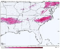
That EPS footprint almost exactly matched the euro graphcast as well toEuro AI in the back ground looking at the euro like:
View attachment 169378
I personally think that 85% of what these models are depicting as ZR is sleet. Miller A storms just don’t have that wide an area of ZRWarm nose is pretty weak in a lot of that freezing rain area on the euro. Probably a lot of sleet pretty far S vs the model depiction marine as far S as the NC SC border
That EPS footprint almost exactly matched the euro graphcast as well to
View attachment 169381Hope Euro continues this southern trend.. It's been a very long time since we've had a CAD dominate system truly work out.
That's a classic setup pattern for many of the winter weather events in North Carolina and would be hard to bet against. Raleigh is usually right on the precipitation transition line one way or the other.for my fellow NC folks -- this is a great account that is consistently very responsible about not declaring things until trends and confidence have really set in; and this was the map they posted an hour ish ago with their current thinking: View attachment 169362
Totals dropped a little due to less qpf guessing
Looks similar to the early Janurary storm.
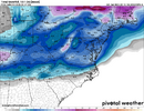
Seems like QPF took a bit of a hit on the 18z EPS View attachment 169375
I think so.Totals dropped a little due to less qpf guessing
im still seeing accounts with 1k+ followers over on X just this past hour or two claiming it is "a DC to Philly hammer" lmao. NoVa/DC likely to be the northern edge at this point, not bullseyeThis is 1-2 more ticks away from a CLT to RDU crush job. Those saying this is a VA special are dangerously close to completely busting unless they're talking about southeastern VA.
View attachment 169390
If completely busting means dropping from a foot to 8 inches with high ratios then I’m for it. However, my gut says that the best baroclinic zone can only trend so far SE in this setup. Not to mention the initial thump in SW VA is not based heavily in 850 FGEN, more in 700…This is 1-2 more ticks away from a CLT to RDU crush job. Those saying this is a VA special are dangerously close to completely busting unless they're talking about southeastern VA.
View attachment 169390
Yep gfs ticked south
Maybe for TN/NC, not for MS, GA, and especially us here in ALYep ole namming coming for most!!lol
This is true to an extent.. But over the last few years these CAD events really haven't worked as well.. All we can do is hope that it works out and becomes a classic CAD winter storm.. But recently they've become much less common.. I've been wondering recently just where did our Central NC, Upstate SC and NE GA CAD systems go?That's a classic setup pattern for many of the winter weather events in North Carolina and would be hard to bet against. Raleigh is usually right on the precipitation transition line one way or the other.
Good luck. If this thing keeps trending flatter much of Virginia won't be getting 8".If completely busting means dropping from a foot to 8 inches with high ratios then I’m for it. However, my gut says that the best baroclinic zone can only trend so far SE in this setup. Not to mention the initial thump in SW VA is not based heavily in 850 FGEN, more in 700…
I’ll die on this hill, hope I’m proven wrong.
Whatever gulf scenario gives us the most moisture over the south, typically wins out. Normally it’s in the form of rain but sometimes the stars align and you get these opportunities.What is keeping the euro so juiced up to go along with the south trends? Seems like other models are trending south with less precip. If I recall correctly, the Euro and Nam may have been too juiced up for one of the recent mid-Atlantic storms and met the GFS in the middle.
That’s some wicked contouring on the EPS..gonna be a messy storm I think and someone is going to experience a lot of pain when it’s all said and done. Fun times ahead though.View attachment 169379
Euro ensembles just an absolute beauty to look at for folks in the row of upper 2-3 counties of NC
Much different than a few days ago when that cold lobe was stretched out into two parts. It’s like the one that was over the northern plains shifted east, fed the 50/50 low, and really allowed these runs to start to manifest. I’m not sure it’s done either.Oh my that’s a big jump southwest on the 18z UKMET with the confluence to our NE. Huge nod to the euro View attachment 169393View attachment 169392
He did say weeks ago he believed there would be a big storm during this timeframe when models showed nothing.I know everybody is wondering what JB has to say about itSo I'll tell ya, He says the storm cuts inside Hatteras. gets to the bench mark 40/70, and he want change his forecast until Tuesday if he has to.
I95 special who would've thunk it....
Of course. Those weenies think every storm is going to hit 40/70.I know everybody is wondering what JB has to say about itSo I'll tell ya, He says the storm cuts inside Hatteras. gets to the bench mark 40/70, and he want change his forecast until Tuesday if he has to.
I95 special who would've thunk it....
I think SW VA will ultimately be ok either way. I won’t be at all surprised to south trends continue for a couple days simply because of how strong blocking has gotten to the north and the fact the confluence continues to trend stronger as well. We have one of the strongest -AOs we’ve seen.If completely busting means dropping from a foot to 8 inches with high ratios then I’m for it. However, my gut says that the best baroclinic zone can only trend so far SE in this setup. Not to mention the initial thump in SW VA is not based heavily in 850 FGEN, more in 700…
I’ll die on this hill, hope I’m proven wrong.

Welcome to the zoo!Hi All, first time poster, long time stalker on this page. Love all the information I have gained over the years in getting into this lovely and frustrating hobby with you all. I have a trip to Pinehurst next weekend and am fretting these trends. Can someone please post the ice maps for the latest euro run? Thanks in advance!! The one and only time I am rooting for a shift north, of course…

Further offshore, late blooming helps NE NC and SE VA looks like. Totals down slightly out WNC@RBR71 how about the 18z MOGreps?


Perfect slp location. Could be a bit more stronger. 1010 or lower. Guessing this doesn't crank muchFurther offshore, late blooming helps NE NC and SE VA looks like. Totals down slightly out WNC
View attachment 169404
View attachment 169405
