I don't usually like posting entire discussions from the NWS, but this is pretty important one out of Raleigh this afternoon:
.LONG TERM /TUESDAY THROUGH SATURDAY/...
As of 400 PM Saturday...
Another dry and cool day is in store on Tuesday with a deep cutoff
low moving east of the Canadian Maritimes and elongated mid/upper
troughing extending to its west into south-central Canada. Meanwhile
a pair of shortwave troughs will dig into the Western US. At the
surface, a strong 1050 mb+ Arctic high centered over the Canadian
Rockies that envelopes much of the Central and Eastern US. The air
mass will modify a bit on Tuesday, with highs ranging from upper-40s
NE to lower-to-mid-50s elsewhere.
A southern stream shortwave will then move across the southern
Plains and Deep South from Tuesday night into Wednesday, spawning a
surface low that develops on a cold front along the Gulf Coast which
deepens and moves NE along or just off the Southeast US coast. With
a cold dry air mass in place ahead of the system and a favorable
surface low track with a "Miller A" setup, confidence is increasing
in a winter storm across at least a portion of central NC from
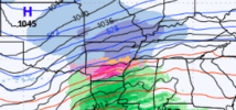
Wednesday into early Thursday. The ECMWF, GFS and Canadian as well
as nearly all of their respective ensemble members continue to
depict this potential. After previous guidance appeared to be
trending temps warmer aloft and more of an ice threat instead of
snow, the 12z ECMWF and its ensembles trended toward a faster
deepening low that tracks slightly farther south. This would result
in a colder solution and more snow and ice for a larger portion of
central NC. Several inches of snow would be possible in our northern
counties in this scenario, with a corridor of significant sleet and
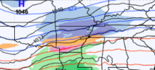
freezing rain in our south. The GFS depicts a weaker surface low and
an 850 mb low that tracks well to our west, resulting in strong
southerly flow aloft that quickly warms temperatures there while
temperatures stay cold near the surface. This would result in much
lighter snow accumulations that are confined to near the NC/VA
border, with a corridor of significant sleet and freezing rain
across the Piedmont and northern/central Coastal Plain, and mostly
rain from around Fayetteville to the southern Coastal Plain. The
Canadian is somewhere in between these two scenarios.
While it is still too early to provide too many details at this
time, we can say that chances of a significant winter storm are
going up, as even if there is a lot of warming aloft, temperatures
near the surface look cold on nearly all model guidance. Of course
this could still change, and all precipitation types from snow to
sleet and freezing rain to rain are on the table. A lot will depend
on the degree of phasing that can occur between the southern stream
wave and a northern stream shortwave diving down from the Great
Lakes, which the ECMWF has more of compared to the GFS. Confidence
has at least improved on timing, with both the GFS and ECMWF showing
the bulk of precipitation occurring from Wednesday morning into
Wednesday evening. So POPs are likely to categorical during that
period, decreasing to mainly chance on Wednesday night and slight on
Thursday in case some light precipitation lingers before the low
exits to the NE. It certainly looks like a juicy system with plenty
of moisture, as ensemble mean QPF is in the 1 to 2 inch range. Stay
tuned over the next few days as details should become clearer.
Temperatures will be highly dependent on the ultimate evolution of
the system, but Wednesday and Thursday are likely to be quite chilly
with highs in the 30s, maybe 40s in the far south. Forecast lows
Wednesday night are in the 20s.


.jpg")


