These bomb solutions really keep the NW flow pumping for a good 12-24 hours after the low pushes up the eastern seaboard
-
Hello, please take a minute to check out our awesome content, contributed by the wonderful members of our community. We hope you'll add your own thoughts and opinions by making a free account!
You are using an out of date browser. It may not display this or other websites correctly.
You should upgrade or use an alternative browser.
You should upgrade or use an alternative browser.
NBAcentel
Member
Looking at the euro more, seems like a lot of the northern part of the ZR footprint (this sounding is my area) would be a ---- ton of sleet with a bigger refreezing layer then melting layer, now this I can work with it 
Freezing rn map is gonna be getting stihl chainsaw sponsor

Qpf is .75 east mtns foothills. Everyone else 1 inch plus
Northern mtns like jimmy said get more from wraparound upslope
Northern mtns like jimmy said get more from wraparound upslope
Qpf is .75 east mtns foothills. Everyone else 1 inch plus
Now that would be a good old fashion winter storm. What’s temps like during the storm on the Euro?
Sent from my iPhone using Tapatalk
Fro thnx for all your post, maps.
Fro thnx for all your post, maps.
Yes thanks to both of you, and Jimmy too!!
Sent from my iPhone using Tapatalk
Mid 20s me back to you at surface when it starts. Stays in 20s throughout at surfaceNow that would be a good old fashion winter storm. What’s temps like during the storm on the Euro?
Sent from my iPhone using Tapatalk
NBAcentel
Member
Sounding near GSO. wow that’s close 
Here are 2m’s and 850’s @ the height of the stormNow that would be a good old fashion winter storm. What’s temps like during the storm on the Euro?
Sent from my iPhone using Tapatalk


NBAcentel
Member
EPS getting way colder with the wedge this run 
Here are 2m’s and 850’s @ the height of the storm View attachment 169142View attachment 169143
Probably pretty sleety for me
Sent from my iPhone using Tapatalk
This 925mb wedge tho 


NBAcentel
Member
EPS much more wintry this run. It’s locking on to a winter storm and doubling down, it’s starting to get hard to avoid 
NBAcentel
Member
Man we are locking this thing in 
Man we are locking this thing in View attachment 169147
Looks awesome, old timey winter storm finally “I hope” and for a lot of folks in one way or another.
Sent from my iPhone using Tapatalk
Full saturation up to 200mb. That’s what a real storm looks like. Not this “do we have enough moisture to saturate the DGZ” crapSounding near GSO. wow that’s close View attachment 169141

NBAcentel
Member
Agree. May not be snowy, but sleet looks the same to the eye when it covers the ground. In all seriousness though there’s certainly some EPS members that raise a eyebrowFull saturation up to 200mb. That’s what a real storm looks like. Not this “do we have enough moisture to saturate the DGZ” crap
View attachment 169148
CNCsnwfan1210
Member
Fro, did the EPS freezing rain areal coverage change much or was it about the same as previous runs?
Sent from my iPhone using Tapatalk
Sent from my iPhone using Tapatalk
CNCsnwfan1210
Member
EPS much more wintry this run. It’s locking on to a winter storm and doubling down, it’s starting to get hard to avoid View attachment 169146
That was a decent shift SE for the snow mean. The 6 inch snow mean crossed the NC border for the first time and a sizable increase for a lot of locales further south. I would love to see that increase as we get closer.
Sent from my iPhone using Tapatalk
NBAcentel
Member
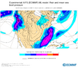
Went up big time, this is one of the higher means for ZR I’ve ever seen, and is seemingly shifting SE a bit, probably signaling more sleet on the NW footprintFro, did the EPS freezing rain areal coverage change much or was it about the same as previous runs?
Sent from my iPhone using Tapatalk


This looks very legit for the NC/VA folks. Going to be a high impact storm. Something else to consider… these are the lows on Friday morning from the 0z Euro. People that lose power in an ice setup are going to be facing dangerous cold.
Elsewhere, snow and sleet that falls will be around for awhile

Elsewhere, snow and sleet that falls will be around for awhile
CNCsnwfan1210
Member
Went up big time, this is one of the higher means for ZR I’ve ever seen, and is seemingly shifting SE a bit, probably signaling more sleet on the NW footprint View attachment 169150View attachment 169149
I was noticing the NW edge was trimmed back some hopefully owing to more colder air working in and more snow. However, with the shift SE even Florence SC (taken literally) has warning criteria ice accrual. For folks in central NC (again) this is a concerning growing signal of a damaging ice storm that’s been consistent for a few days now. I certainly hope that we can continue to trend colder with more confluence/cold press up north to introduce more snow to the equation, I’m just not sure if that’s going to happen though at this time. Folks in NC really need to pay attention carefully to the trends with this system as this could be a high impact winter storm.
Sent from my iPhone using Tapatalk
So in order for Central NC to avoid the ice storm solution we need it to trend colder than what it is now on models?I was noticing the NW edge was trimmed back some hopefully owing to more colder air working in and more snow. However, with the shift SE even Florence SC (taken literally) has warning criteria ice accrual. For folks in central NC (again) this is a concerning growing signal of a damaging ice storm that’s been consistent for a few days now. I certainly hope that we can continue to trend colder with more confluence/cold press up north to introduce more snow to the equation, I’m just not sure if that’s going to happen though at this time. Folks in NC really need to pay attention carefully to the trends with this system as this could be a high impact winter storm.
Sent from my iPhone using Tapatalk
Sent from my A600DL using Tapatalk
NBAcentel
Member
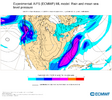
Yep. AIFS crept to that higher impact look with far more QPF and a significantly colder wedge 
CNCsnwfan1210
Member
So in order for Central NC to avoid the ice storm solution we need it to trend colder than what it is now on models?
Sent from my A600DL using Tapatalk
Yes, really need to get rid of the warm nose in the upper levels of the atmosphere to cool the air column sufficiently for snow. Surface low track further SE, more confluence/cold air press from the north will help with that, that’s what we need.
Sent from my iPhone using Tapatalk
CNCsnwfan1210
Member
Yep. AIFS crept to that higher impact look with far more QPF and a significantly colder wedge View attachment 169156
2M temps below freezing deep into NC on that run
Sent from my iPhone using Tapatalk
NBAcentel
Member
The euro graphcast has so much upstream confluence this run that it seemed to keep areas along 85/northwest below freezing at 850mb with still a high QPF event, along with a colder wedge. Interesting move from it
The models might change from run to run but climo is hard to beat. For snowfall, the CIPS analogs have been consistent the last couple of days with a cutoff near the GSP-CLT-RDU corridor. And on the west side of the Apps, it's been showing the cutoff near the southern TN border. Overall, the footprint is very similar to the WPC maps. Unless something drastic changes at H500 these maps aren't going to move all that much.


NBAcentel
Member
06z icon with the snowiest run yet
NBAcentel
Member


If you're in my area (Columbia) hoping for a good outcome of this storm, it's going to be ice if anything Wintry at all. Careful. The snowfall ptype maps that were posted yesterday were from something entirely different (whiff wise) that the Euro AI was showing, and it along with it's Euro/EPS brother are getting icier. We are seeing surface temperature changes of the -10F between run range on recent modeling getting the area really close to freezing with no chance of it being snow.
The local office (CAE) is concerned that the ptype would be freezing rain also, with the setup.
The local office (CAE) is concerned that the ptype would be freezing rain also, with the setup.
CNCsnwfan1210
Member
That’s an impressive shift south, tower
Sent from my iPhone using Tapatalk
CNCsnwfan1210
Member
That’s an impressive shift south, wowzer!
Sent from my iPhone using Tapatalk
Sent from my iPhone using Tapatalk
CNCsnwfan1210
Member

6z icon further south, with more snow into NC/ice further south. Complete misses DC and the NE for that matter
Sent from my iPhone using Tapatalk
NBAcentel
Member
Looks like the GFS is more amped but way colder at the SFC again, gonna probably be a big winter storm for NC this run regardless, more towards the euro