Still have no idea how Durham and Orange aren’t under Winter Storm Warnings. Sounds like both counties had the majority of their area reach warning criteria. Meanwhile, we get WWAs for cold rain.
-
Hello, please take a minute to check out our awesome content, contributed by the wonderful members of our community. We hope you'll add your own thoughts and opinions by making a free account!
You are using an out of date browser. It may not display this or other websites correctly.
You should upgrade or use an alternative browser.
You should upgrade or use an alternative browser.
Yep - 3” is about when the grass is completely covered. Been a long time!
 some of you guys need to step up your lawn game
Yeah that’s what I wanted and we easily surpassed that. After that, any additional accumulation is just icing on the cake. You get a white blanket either way!Yep - 3” is about when the grass is completely covered. Been a long time!
Hoping we can do a relatively decent job holding on to our snowcover tomorrow with the ULL hopefully keeping things cloudy. Because the late February sun is going to be out for blood. Honestly, don’t expect the south facing hills to make it out alive, but would be nice for the generally sunny, flat areas to make it to Friday.
NBAcentel
Member
The storm that doesn’t want to quit 
This bad boy means business

Quite a few yards around me still have some grass sprouting up. I patently refuse to mow after October if the grass grows up to my windows.
SimeonNC
Member
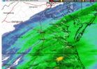
Do you notice the ULL already producing more precip than modeled over the TN Valley?The storm that doesn’t want to quit View attachment 170965
lcpdk
Member
We refuse to mow the onions until regular grass starts to grow.
NBAcentel
Member
This hrrr run trying to print out some isolated 1.5-2” amounts from the convective snow band in Rowan/iredell/meck/cabarrus county. Impressive
Looks like we could have off and on snow showers for quite a while longer
Mpirone12
Member
Can you post it by chance?This hrrr run trying to print out some isolated 1.5-2” amounts from the convective snow band in Rowan/iredell/meck/cabarrus county. Impressive
- Joined
- Jan 23, 2021
- Messages
- 4,603
- Reaction score
- 15,199
- Location
- Lebanon Township, Durham County NC
Okay I need you to go study up on 1/23/03. I’m not saying it’ll happen but it has several similarities.This hrrr run trying to print out some isolated 1.5-2” amounts from the convective snow band in Rowan/iredell/meck/cabarrus county. Impressive
i feel like the storm saw those out-to-lunch models bombing the forecasts less than 24 hours in and was like "hmmm no, i'll show them what im really about"The storm that doesn’t want to quit View attachment 170965
Can you post it by chance?

Mpirone12
Member
What’s going on with the ULL scheduled to come tomorrow am?
Downeastnc
Member
Closing in on 3" of sleet...still pouring sleet

NBAcentel
Member
Interesting features within this band looks like eddies or perhaps mini meso lows ?
Yea, I posted about that in the other thread. Durham/Orange got more than Wake did, but ya'll are under an advisory..Still have no idea how Durham and Orange aren’t under Winter Storm Warnings. Sounds like both counties had the majority of their area reach warning criteria. Meanwhile, we get WWAs for cold rain.
I mean I dunno if it's that big a deal? 3-4'' gives the same enjoyment regardless of the NWS product you're under. But I also wonder what's the point of having criteria if it ain't being applied?
Still baby flakes flying here 27/19
Interesting features within this band looks like eddies or perhaps mini meso lows ?
breakfast pizza for @Mitch West ?!
SimeonNC
Member
Interesting features within this band looks like eddies or perhaps mini meso lows ?
There's actually some AGL CAPE at the end of the HRRR lol

Closing in on 3" of sleet...still pouring sleet
Same, don’t see any grass, basically just a solid crust of ice covering everything, including the roads. Interstate heading out of town is pretty thrashed, just got home from picking up the wife. This would have been a good one if all snow, QPF was definitely there. Kudos to the models which showed a QPF max extending SW from the Albermarle through Pitt, that’s typical for these coastals.

CNCsnwfan1210
Member
I’m up to 1.5 inches of snow/sleet here in Lucama NC, light sleet still falling at 7:45pm [mention]Webberweather53 [/mention]
Sent from my iPhone using Tapatalk
Sent from my iPhone using Tapatalk
Looks like there's 3 bands of snow, one thru the southside(7 cities) a 2nd one extending thru emporia, wakefield onto the peninsula, and a surprisingly heavy band extending from Richmond NE towards the Chesapeake. I'm not sure if that one was modeled well, I think I remember the NAM showing something like that the other day when it was way NW with precip?
Attachments
Warm nose is stout and not going anywhere anytime soon!

Yes and it was definitely a fly in the ointment for GSP that nightLook yall I ain’t saying it’s gonna happen but I’ve seen this movie with Lee Side enhancement about 22 years ago.
NBAcentel
Member
Getting another burst of moderate snow
I can tell those returns over Union County is some very big snowflakes and sleet pellets mixed. I’ve officially got my 2nd dusting of the day.The storm that doesn’t want to quit View attachment 170965
Tsappfrog20
Member
Total 3.6” in Youngsville!!
Sent from my iPhone using Tapatalk
Sent from my iPhone using Tapatalk
What happened?Yes and it was definitely a fly in the ointment for GSP that night
WxBlue
Meteorologist

3.0" in Wendell. Probably our final amount.
Webberweather53
Meteorologist
My folks in Hope Mills reported 0.12” of ice and about 0.3” of sleet. No snow down in the Fayetteville, NC as expected
mx3gsr92
Member
Sleet finally over! Back to 1-2"/hour rates. 4 hours to get to the promised land!
Just went on this 90 minute walk with 3 shots of really good scotch in the cup, covered 3.5 miles in the heaviest snow of the day, this is why we do this
As a tidbit, this is currently the single biggest storm here since January 3rd, 2018. I measured 10.5in in that storm.. not as much wind with this one however!Approaching 7 inches here in Franklin, intensity has leveled off as it looks like I'm in a lull between heavy snow bands
January 23, 2003. All forecasts for the SC upstate and the NC southern Piedmont and foothills was for 1-2” of snow. However about 5 or 6 hours before the event started short term models started to show the the development of a mesolow that GSP called a fly in the ointment to their forecast in the evening discussion. The storm ended dumping as much as 18” across the southern foothills and 6-9” across CLT metro in just a few hours. There was thundersnow and it was an unheard of around here 40:1 snow to liquid ratio. CLT officially got 8.5” at the airport with only .15 QPFWhat happened?
WolfpackHomer91
Member
My folks in Hope Mills reported 0.12” of ice and about 0.3” of sleet. No snow down in the Fayetteville, NC as expected
I hate that ! I follow that Guy Snowhound on Twitter from there …. Hell of a nice guy
Sent from my iPhone using Tapatalk
rburrel2
Member
nice little rain shower here just now.