Bigedd09
Member
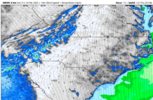
Wasn't the nam 3k picking up on this last night? it showed flurries all night lolFor some reason there’s snow breaking containment and moving east of the mountains already View attachment 170919
Wasn't the nam 3k picking up on this last night? it showed flurries all night lolFor some reason there’s snow breaking containment and moving east of the mountains already View attachment 170919
Probably something to do with the 40-50 mph wind gusts blowing in above 5k feet lolFor some reason there’s snow breaking containment and moving east of the mountains already View attachment 170919
Yes and I’ve flipped back to light snow after getting a a frozen mist falling for a while.Filling back in around the clt metro a bit. Good sign for those further east View attachment 170900
I am not familiar with this. Is this just NW flow that breaks containment? I never remember the upstate getting in on NW flow, it usually dries us out and clears us off. Also; 11z would be what, 6am?
Even when it’s cold it’s still mixing. SMH
I think the HRRR did well too today at least for mby
It took until this morning to finally catch on. Outside of 12 hours it was bad.I think the HRRR did well too today at least for mby
That’s a good sign considering the strangest energy hasn’t even approached yetFor some reason there’s snow breaking containment and moving east of the mountains already View attachment 170919
oooh i can get somma dat?
Somebody smarter than me would have to tell you why it's convective like that. But I believe in a general sense it's developing b/c of the lee-side troughing effect from the surface wind trajectory of the CAA around each side of the higher mountain peaks which leads to rising air in the low levels.I am not familiar with this. Is this just NW flow that breaks containment? I never remember the upstate getting in on NW flow, it usually dries us out and clears us off. Also; 11z would be what, 6am?

my guess is we are going til 7ish in the NE Durham/Falls Lake area. my flakes are still huge and the rate is moderateThere does look to be some back filling on the radar. I'm still getting moderate snow. Be nice to finish with 4" tonight (not far off now) and then get another positive surprise tomorrow morning. **I'm allowed to wish...
You think we got another round moving in tonight?
Somebody smarter than me would have to tell you why it's convective like that. But I believe in a general sense it's developing b/c of the lee-side troughing effect from the surface wind trajectory of the CAA around each side of the higher mountain peaks which leads to rising air in the low levels.
We've also got some energy and moisture swinging through with the 700-750mb level trough at the same time that plays a part in it.
View attachment 170930

Is that what will still fall starting now?End of the most recent HRRR run at about 10am tomorrow morning, it's still snowing over the W. Piedmont btw.
View attachment 170934
There is no way I see the 2.4 it shows (not even 1/2 that)...now NE of me may very well verifyEnd of the most recent HRRR run at about 10am tomorrow morning, it's still snowing over the W. Piedmont btw.
View attachment 170934
The HRRR has the snow over the W.Piedmont developing in the early morning with the ULL lolIs that what will still fall starting now?
Fro: Is this a premium + add on with Radarscope? I don't see it ....and its very nice to see some "backbuilding". Maybe the lee side meso will over produce for us in the Western Piedmont.
