SouthSideYankee
Member
Just drove from work in RDU area to Durham and it’s definitely sticking in Durham better. Just the slight in temps I guess.
What’s that? A good hours worth of heavy snow? Probably 1-1.5 inches worth?

Being right above the mix line is proving fruitful right now. You can watch precip hit the Chatham / wake line and blossom
Gonna be close, might clipFlakes have gotten smaller here. Looks like 3/4”. We are on the NW edge and I’m not sure exactly where the radar will backbuild and pivot with the coastal development. Hrrr says we stay in moderate returns the next 4 hours. Regardless, I call it a win. @Myfrotho704_ are those returns down your way going to make it this far north up I-85?

You positive you ain’t talking about the norovirus toilet demons ?It’s ripping now
A bust for me but will gladly take it! I’ll probably still bet on mixing next time but enjoying this. Daytime snow with big flakes right now and no mixing… I’m good!So much for the feared warm nose…take that NAM.️
Was just gonna ask if those heavier returns also meant a lurch north of the mix lineRemember according to the HRRR like 5 ho
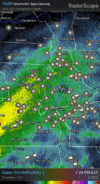
CC line is actually a lot closer to Raleigh than that depiction suggests
View attachment 170859
Yeah, it's a good day. I got maybe 0.5" and a few hours to go. So maybe 1.5-2" total looks reasonable.A bust for me but will gladly take it! I’ll still bet on mixing next time but enjoying this. Daytime snow with big flakes right now and no mixing… I’m good!
Well, I think we know the answer to this one now as I watch the road turn white outside.This does feel like a panic we could be laughing at this time tomorrow while the snow falls. Or it may truly be disaster. Somehow, I feel like I am less sure about what’s going to happen with this storm than I’ve been in a week, and it’s starting in under 18 hours (if it starts at all). LOL!
Looks more like this to meRemember according to the HRRR like 5 ho
CC line is actually a lot closer to Raleigh than that depiction suggests
View attachment 170859


It’s ripping but the back edge is already here. Needs to pivot *now*I don't think it will accumulate much, but nice to see a steady snowfall in CLT. The backside is approaching faster than I thought as it's heading more in the East direction rather than Northeast.
I'm a little suprised that game is still going to happen the roads will be a complete messGonna be a mess for people to get to the State-Carolina game
C’mon, I don’t want to be right in this situation. Don’t tell my wife.Just read a report of sleet in Garner over at the other site, so the warm nose might be moving north. Let’s hope it doesn’t get too far…
im getting absolutely raked ....MASSIVE cotton ballsIt’s always something around here. Look at the returns just vanishing.
The snow is starting to mix with sleet at my house near the McCullers community. I think that infamous 850 warm nose is introducing itsself.Just read a report of sleet in Garner over at the other site, so the warm nose might be moving north. Let’s hope it doesn’t get too far…
Not sure if that heaviest axis might actually verify nw of that, best banding has been to my NW all day and has got to be some 2" totals under already somewhereView attachment 170863
Here's the latest GFS accumulation map. It looks like this might come closer to verifing that many of us including me at times believed.