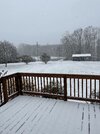
Not horrible. Pups are enjoying it. ")


It’s pouring snow in at the office in Rock Hill. Should bode well for Charlotte!
lol the way he is acting like NO ONE predicted richmond was getting under 6 inches.... when most of us on here agreed that seemed too lofty of a forecastDT backtracking on his very bullish forecast, LOL (sucks for our RIC folks, though):
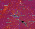
115 pm Radar update....
Everything north and west of the black line is light snow and snow intensity is so light that I doubt if anybody north of the black line is going to get anything over 2 inches and that includes Richmond. In essence everything north and west of the black line is falling apart faster the Kansas City's offense line in the super bowl.. The blue area is represent pockets of moderate snow embedded in the light snow.
There is No doubt my forecast is going to bust terribly in the Virginia Piedmont and in the Richmond Metro area. Even worse is the fact that all the short Range model data have also performed very badly.
Usually you can anticipate some kind of error or break down at some portion of a forecast because of various factors. You should expect some kind of glitch in the short range models that missed a particular aspect of a storm whether it's rain or high winds or cold or snow. But even early this WED morning all of the short Range models had Richmond getting 5 inches of snow and that is clearly not happening.
Even the low end snow forecast are going to be wrong . No one north and west of the Black line is getting 2-6” of snow. And yeah from what I can see all the TVs forecast in the Richmond Metro area are going to bust too.
Raleigh and Northeast North Carolina still have a really good chance of getting three to six inches of snow out of this and Hampton Roads it still has a very good chance of getting eight of more inches out of this
The last two events I did really well and I was very pleased with the forecast. But this one I will end up easily being my worst perform of the winter. A very difficult and frustrating storm.
Cool pic, off lake wheeler?

Filling in nicely SW of CLT on tilt 2. Might be some heavier snow rates around the city the next couple of hours View attachment 170820
Down to flurries here now, need that band to our west to move in or the coastal to start exploding. Oh well, I’d rather get most of our snow once the sun gets a lower anyways. I’m a road sticking weenie and that’s going to be tough in the early PM.past five minutes here, rate has slowed ever so slightly but in exchange for BIGGER flakes. i am perfectly happy with this trade off!

Lost chicken feathers again. back to nickle/dime flakes. They have over achieved here no doubt. Should really help those north of 64 out to the coast, where the band has set up shop/ headed . They will get killer rates/ flakage till past dinner time. GSO will slow down here rest of afternoon. Have to crawl to the 2-3 inch mark.Dang, you’re beating us out this way! Didn’t expect that, although I guess we’ve got longer to go out here, most likely! Excited to be included in the SPC’s latest circle.
It does seem rates have dropped off a little now.

What's that blue hexagon on the far-right?These banding features are really picking up some steam View attachment 170824
Mid Pines! Josh Hamilton grew up there.Chilling on the NCSU farmland down near the creamery it’s been consistently coming down for a while now. The gravel road is white but assuming pavement still just wet
Looks like you could have some Squatch's living back there

S Raleigh is edging the mix line but still all snow or like 90% snow here
Sent from my iPhone using Tapatalk


Where I’m at in Kernersville it still appears to be coming down at a reasonable rate, maybe not quite as much as it was 20-30 minutes ago, but given the expectation going into today, it is about what I thought it would be. Not disappointed overall.It's slowing down here in eastern Forsyth County NC. I haven't measured but guessing 1/3 to 1/2 inch. Grassy areas and elevated surfaces have a nice coating.