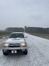
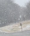
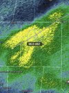
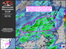
Roads are very wet here. We were not lacking moisture, per se. Temperatures were an issue about like you would expect.
-
Hello, please take a minute to check out our awesome content, contributed by the wonderful members of our community. We hope you'll add your own thoughts and opinions by making a free account!
You are using an out of date browser. It may not display this or other websites correctly.
You should upgrade or use an alternative browser.
You should upgrade or use an alternative browser.
I can't remember the last time Wake was under a Warning, but not Durham/Orange. The reverse seems like a regular occurence.Have to wonder if RAH might look to add Durham and Orange counties into the WSW suite
SnowNiner
Member
Snow starting to move into north meck View attachment 170789
Kids texted a picture from home in Troutman, legit dusting in the back yard.
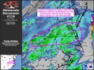
I don't know about LP track but thinking pressure drop intensity and precip spread causing enough warm nose to come back into part of the triangleYou mean like hugging?
not often for a snow system am i glad that im on the NE part of durham... but today, oh YES i am!! been ripping hard for an hour and if this keeps up through 6-7p... King GFS really might verifyFalls lake area is getting pounded
That’s my worry with this earlier / stronger WAA-induced precip…it’s probably going to bring more WAA mixing issues later. But we’ll take it since you have to risk getting burnt to score sometimes.I don't know about LP track but thinking pressure drop intensity and precip spread causing enough warm nose to come back into part of the triangle
I do think we may have a relative lull in precip coming up as the coastal takes over which could result in some melting in the meantime, hopefully not.
My car thermometer read 27F on the way back from the gym.
I would think the pressure drop would cool down the boundary level, but who knows. Nice snow right now just south of RaleighI don't know about LP track but thinking pressure drop intensity and precip spread causing enough warm nose to come back into part of the triangle
campamy
Member
Radar is clear but nice little flizzard coming down!
SimeonNC
Member
And the snow stopped...
Have to leave that up to WebbcastingI would think the pressure drop would cool down the boundary level, but who knows. Nice snow right now just south of Raleigh
Just a sick snow band moving through Roxboro
- Joined
- Jan 23, 2021
- Messages
- 4,602
- Reaction score
- 15,197
- Location
- Lebanon Township, Durham County NC
Duke Heliport doesnt report ptypes but vis has been down to half a mile for the last two obs.
SimeonNC
Member
Is it still snowing for any other Charlotte area peeps, not counting the ones up in Iredell county.
wow
Member
Big flakes coming down now.. mod/hvy snow still in Mooresville
packfan98
Moderator
Starting to pick up some here at home. hrrr is finally getting a clue for the Triad.


broken025
Member
I have light flurries here in Ballantyne.Is it still snowing for any other Charlotte area peeps, not counting the ones up in Iredell county.
Uptown yes for now.Is it still snowing for any other Charlotte area peeps, not counting the ones up in Iredell county.
Some flurries still imbyIs it still snowing for any other Charlotte area peeps, not counting the ones up in Iredell county.
yeahhhhh i am confused by that too, especially for durham.Have to wonder if RAH might look to add Durham and Orange counties into the WSW suite
im at 28 / 24 right now, and the few times ive checked my silly weather app to see what it is trying to claim for futures, it keeps saying there will be a pause soon... but there has not been a single pause in these bigger flakes since they started an hour and a half ago lol
CltNative90
Member
It’s lightened up but still snowing here off of S. Tryon.Is it still snowing for any other Charlotte area peeps, not counting the ones up in Iredell county.
Fast approaching 1 inch mark up here at work. Big time rates goes back an forth between chicken feathers and quater sized. All chicken feathers again now. Parking lot / side roads Caving in fast
JimBobs
Member
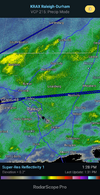
Extrapolating from the radar, looks like South Charlotte could get snowglobe conditions for the next couple hours and result in a dusting. Unless the Low throws back some more precipitation later today or tomorrow. Not counting on it. Our long term accumulation poverty streak looks like it will continue in the South Mecklenburg / Fort Mill direction of the metro. Wish we could at least get a single measurable 1-inch deep snow on the ground, it's been such a long time.
- Joined
- Jan 23, 2021
- Messages
- 4,602
- Reaction score
- 15,197
- Location
- Lebanon Township, Durham County NC
If I have 2" to go according to the HRRR, we're gonna be right around 3". No signs of IP.
norcarolinian
Member
Like that, passed the 1 inch mark. Be at 2 in 30-40 mins, if this keeps up GSO
CltNative90
Member
I still think the ULL tomorrow morning could accomplish that for some in our area. Temps are going to be a lot more favorable. Just has to materialize.Extrapolating from the radar, looks like South Charlotte could get snowglobe conditions for the next couple hours and result in a dusting. Unless the Low throws back some more precipitation later today or tomorrow. Not counting on it. Our long term accumulation poverty streak looks like it will continue in the South Mecklenburg / Fort Mill direction of the metro. Wish we could at least get a single measurable 1-inch deep snow on the ground, it's been such a long time.
- Joined
- Jan 23, 2021
- Messages
- 4,602
- Reaction score
- 15,197
- Location
- Lebanon Township, Durham County NC
I'm ten miles south as the crow flies from TDF and it's been pounding here. TDF updates every fifteen minutes, I believe.is anyone active in the thread right now located up near roxboro or henderson? both seem to be hit with insane bands right now, would love to know how it looks up there
Dang, you’re beating us out this way! Didn’t expect that, although I guess we’ve got longer to go out here, most likely! Excited to be included in the SPC’s latest circle.Like that, passed the 1 inch mark. Be at 2 in 30-40 mins, if this keeps up GSO
It does seem rates have dropped off a little now.
I'm starting to see ice build up on trees and surfaces here, 29F it won't take long. I hope to get more sleet like it was earlier
Just started to whitening the roofs in our neighborhood,
Then stopped.
More than I expected so it's a to win!
Third time this year I've seen snow.
Comparing to the last 3 years is a huge improvement but,
Considering I can take all 3 combined for less than 2 inches maybe less than an 1.5 not good but my expectations have really came down over the last 3 years!
Last edited:
SimeonNC
Member
@Myfrotho704_ We might get clobbered in the next couple of hours, relatively speaking

