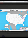
CMC and Icon winter wx footprint are similar
-
Hello, please take a minute to check out our awesome content, contributed by the wonderful members of our community. We hope you'll add your own thoughts and opinions by making a free account!
You are using an out of date browser. It may not display this or other websites correctly.
You should upgrade or use an alternative browser.
You should upgrade or use an alternative browser.
Pattern Failboat February
- Thread starter SD
- Start date
CMC too far South and East.
CNCsnwfan1210
Member
It did seem though that the CMC also shifted further south with the system
Sent from my iPhone using Tapatalk
Sent from my iPhone using Tapatalk
Icon
CMC
GFS ( )
)
CMC
GFS (
)WolfpackHomer91
Member
GFS Did have a solid helping of ICE though In NC
Definitely gives me Dec 2017 vibes with those 3 maps. Gfs was last to catch on there. Let’s get the eps and euro on board. I really didn’t want to do this again but here we are 
I'll let others post those CMC epic clown maps, the sleet and freezing rain is about what you'd expect from Canada lol


Last edited:
would be right on the edge of that damn snow/sleet&FR line if this verified.Youre 40 miles N of Charlotte man lol
Tsappfrog20
Member
This smells like one of those storms where Charlotte gets a foot and Raleigh gets rained on. Sorry Raleigh folks.
Normally in these situations Raleigh over performs more than Charlotte has lately
Sent from my iPhone using Tapatalk
If these model maps verified, Central North Carolina and parts of South Carolina would be sent back to the dark ages literally. The number of downed limbs and trees and damage to the power infrastructure would have an impact like that of a major hurricane. I don't believe this will even be close to what happens late next week but the signals are there for a major winter weather event for the Carolinas.
SnowNiner
Member
This smells like one of those storms where Charlotte gets a foot and Raleigh gets rained on. Sorry Raleigh folks.
I feel like this storm is going to be just like this week’s storm, with a bit more sleet and freezing rain further south….but mostly rain for both cities. Could be wrong, but it just seems very similar to me.
packfan98
Moderator
Alright folks. Take the trolling and banter elsewhere. We are trying to track a potential event here.
Yeah, this is most likely way over done. Probably just the same Canadian foolishness as usual.If these model maps verified, Central North Carolina and parts of South Carolina would be sent back to the dark ages literally. The number of downed limbs and trees and damage to the power infrastructure would have an impact like that of a major hurricane. I don't believe this will even be close to what happens late next week but the signals are there for a major winter weather event for the Carolinas.
Last edited:
SnowNiner
Member
Normally in these situations Raleigh over performs more than Charlotte has lately
Sent from my iPhone using Tapatalk
If the late blooming Miller a, late phase stays on the table, absolutely Raleigh would win here. Everything in the table.
MichaelJ
Member
If this trends NW(which is entirely possible depending on the strength and position of the 50/50) the northern most part of NC would get mainly snow while the rest gets a very nasty and damaging ice storm. Triangle and the UPSTATE would be shut down for days I am afraid if this plays out this way. The caveat being we are still too far out to get an approximate track or QPF numbers so we will wait for some later runs to see which way it is trending
NBAcentel
Member
Seems pretty different to me, got 2 major ens/nice amount of global/AI (including the EC graphcast) support other then the GFS (which went colder) and last nights euro so far.I feel like this storm is going to be just like this week’s storm, with a bit more sleet and freezing rain further south….but mostly rain for both cities. Could be wrong, but it just seems very similar to me.
LukeBarrette
im north of 90% of people on here so yeah
Meteorology Student
Member
2024 Supporter
2017-2023 Supporter
I know you’re probably new to this board but as a VA guy myself, don’t speak to the other board members this way. In this house we respect our Carolina brothers and sistersCMC too far South and East.
rburrel2
Member
Feels like a pretty major Euro/EPS run today. We would love to see it go in to the icon/pangu/cmc/euro ai camp.
CNCsnwfan1210
Member
Give us a UKMET run burrel when it comes out
Sent from my iPhone using Tapatalk
Sent from my iPhone using Tapatalk
hands up for anyone who lived in NC during the insaneeee ice storm of 2002 *raises hand*If these model maps verified, Central North Carolina and parts of South Carolina would be sent back to the dark ages literally. The number of downed limbs and trees and damage to the power infrastructure would have an impact like that of a major hurricane. I don't believe this will even be close to what happens late next week but the signals are there for a major winter weather event for the Carolinas.
i was just a kid but that ---- was INTENSE. out of power for two weeks, hazardous to even try to walk around outside for days on end, let alone drive.
Last edited:
packfan98
Moderator
GEFS improved

NBAcentel
Member
More 50/50 influence on the gefs 
2002?hands up for anyone who lived in NC during the insaneeee ice storm of 2022 *raises hand*
i was just a kid but that ---- was INTENSE. out of power for two weeks, hazardous to even try to walk around outside for days on end, let alone drive.
packfan98
Moderator
UKMET is looking good

Yep we've got the playbook down. I'm not sure if we can get there, but we know what we need at least.More 50/50 influence on the gefs View attachment 168698
packfan98
Moderator
UKMET

Yep. Certainly more in line with Icon/CMC as far as footprint. Just lacking on the southern end which is more realistic anywayUKMET
- Joined
- Jan 23, 2021
- Messages
- 4,603
- Reaction score
- 15,199
- Location
- Lebanon Township, Durham County NC
Okay now that has my attention. Kuchera maps look similar.UKMET
GFS is the early outlier. No surprise there
JHS
Member
It has to be 2002 and yeah that one was rough. We got lucky with having our power off for only 2 days with it.2002?
SnowNiner
Member
Seems pretty different to me, got 2 major ens/nice amount of global/AI (including the EC graphcast) support other then the GFS (which went colder) and last nights euro so
Yeah that’s fair. We definitely have more support this time. I mean similarities synoptically, we had blocking, 50/50, not ideal western ridging causing some SE ridging that we had to beat down. We lost that battle and got 2 days of 30s and rain.
This time, same principle to me but there’s less SE ridging, seems colder and more going for us, thus the better model runs. Is it enough for a major winter storm? I don’t know and I hope it is. I’d like to see the orange anomolies erased from the SE and I’ll be more confident.
12z Euro. Big winter storm for the Carolinas/VA

Areas west of there?12z Euro. Big winter storm for the Carolinas/VAView attachment 168699View attachment 168701
yes, sorry! definitely meant 2002 haha2002?
rburrel2
Member
Big shift south on the Euro, even with a very icky looking progression of the northern stream. Love to see it. Our goal posts might be widening a bit for this storm.
Every major global now showing a significant winter storm for NC/VA with this system. All of them except the GFS show a significant winter storm for SC as well.
Every major global now showing a significant winter storm for NC/VA with this system. All of them except the GFS show a significant winter storm for SC as well.
Michael
Member
From yesterday, CPC on their gameBig shift south on the Euro, even with a very icky looking progression of the northern stream. Love to see it. Our goal posts might be widening a bit for this storm.
Every major global now showing a significant winter storm for NC/VA with this system. All of them except the GFS show a significant winter storm for SC as well.
Attachments
rburrel2
Member
GFS is out to lunch with timing of precip as well, which tells me it's probably just wrong in general.
ICON/CMC/Euro all have the best precip coming through Upstate SC between midnight and 7am Thursday morning.
The GFS says we're done with precip by noon Wednesday.
Ukmet is in between those two camps.
ICON/CMC/Euro all have the best precip coming through Upstate SC between midnight and 7am Thursday morning.
The GFS says we're done with precip by noon Wednesday.
Ukmet is in between those two camps.
rburrel2
Member
Also just fwiw... but the icon/cmc/euro are all generating a secondary batch of precip from the that rotating donut. And that's where the best/further south/colder winter storm chances come in to play
The GFS is further East with the donut and doesn't have that secondary batch of precip. So we may actually want to root for the cutting off donut to be further west?? That also really helps with the CAD getting established.
The GFS is further East with the donut and doesn't have that secondary batch of precip. So we may actually want to root for the cutting off donut to be further west?? That also really helps with the CAD getting established.
iGRXY
Member
I’ve been in a wait and see approach so far vs tracking this particular threat. Between December and January of nonstop tracking I needed a break. Right now what I will say is this along and north of 40 I feel more and more comfortable in snow. South of there into the CAD regions of SC and NEGA in thinking a big mix of all p-types right now. You’ve seen that on models and ensembles with some showing more snowier solutions and others with more ice. The EPS from 0Z really sounding the alarm bells for that. I’m not going to get invested until we are in the day 3-4 range. Been burned too many times so far this winter
broken025
Member
B dog is in
