• Hello, please take a minute to check out our awesome content, contributed by the wonderful members of our community. We hope you'll add your own thoughts and opinions by making a free account!

Pattern Failboat February

It's honestly incredible how quick we went from day 15 Southeast death ridge predictions to this on all the models. Is the forecasted Strat split doing work that fast? and models are catching up to it?
To me I think it’s the modeling starting to pick up the MJO influence as it heads into phase 8 (that they were to weak with) hence the pacific jet trending more favorably, and the -NAO trend from the wave 2 split which favors NATL blocking. Lots going our way
 
To me I think it’s the modeling starting to pick up the MJO influence as it heads into phase 8 (that they were to weak with) hence the pacific jet trending more favorably, and the -NAO trend from the wave 2 split which favors NATL blocking. Lots going our way
Yeah it's hard to believe how many things seem to be aligning for us. I mean I know the chickens haven't hatched yet, but this is just about as good of an alignment/convergence of big picture items as you could ask for.

Blocking is huge, and huge blocking is showing up. Somebody is going to score and score big out of this, as long as it continues to show up. Buckle up!
 
I’m actually pretty concerned with the ice storm potential here. You start pumping the SER with that level of CAD signature at the surface and you’re asking for big big big trouble. Obviously would need to get closer to see how this materializes and the over level of cold air throughout the column (short range stuff) but as it stands that’s a big setup for ZR. Not just your ZR on the clown maps that we know would be sleet but legit ZR.
 
LC
Evidence for a major cold snap in the second week of February has increased, and I would be surprised if somewhere east of the Rocky Mountains was not hit by a heavy snow/ice and possible blizzard in the 11-15 day period. And I think that there will be another such storm and cold spell before February is finished. But I am convinced that the spring season will have an early start to warmth, largely because:

1) Blocking signatures have never stabilized for any great length of time
2) The heat ridge over the Greater Antilles is building into the Sargasso Sea, which usually translates to a prominent Bermuda High
3) Dryness is enveloping the Southwest and High Plains back into Mexico (favors early formation of a Sonoran heat ridge)
4) The Madden-Julian Oscillation has been oriented toward the Southern Hemisphere, which almost always leads to widespread warmth and ridging over the lower 48 states
5) Arctic vortices and troughs have seldom linked with equatorial forcing

See also that while January was fairly cold through much of the USA, the temperatures were only briefly extreme and set up a tepid first two months of the DJF time frame. The lack of moisture west of the Mississippi Valley (outside of the Pacific Northwest) is an indicator for drought, which in turn points toward a rather warm spring with thunderstorm risks emerging over TX, OK, KS early before dryness overtakes the middle chamber of the nation.
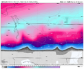
 
sun angle only matters really with snow staying power. Just melts faster. (asphalt specific heat for ex.) Any winter storm formation given right conditions is generally not in play with this until very late in the season
 
No wonder the AI is seemingly improving as well. Notice prior, the height field is becoming more suppressed. Sets up the baroclinic some further south and and settles in stronger cold air advection and high pressure for CADView attachment 167559
This results in a stronger confluent press in SE Canada and a colder storm IMG_4913.gifIMG_4914.gif
 
347d309b674892819964fb3a50f61215.jpg

EPS with a -AO of -2 + sigma as we approach mid FEB


Sent from my iPhone using Tapatalk
 
Back
Top