-
Hello, please take a minute to check out our awesome content, contributed by the wonderful members of our community. We hope you'll add your own thoughts and opinions by making a free account!
You are using an out of date browser. It may not display this or other websites correctly.
You should upgrade or use an alternative browser.
You should upgrade or use an alternative browser.
Pattern Fail or Fab February 2023 Pattern Thread
- Thread starter Metwannabe
- Start date
Don't need one too strong. weak nino would be goodIf we are el neutral next winter it'll make you think this was a good winter
There's honestly no good ENSO. It seems every winter is worse than the last.Don't need one too strong. weak nino would be good
Until we find a way to keep the mjo out of the warm phases or only have brief glancing passes not much will change. The only real hope I can find for next year is maybe a WEN trying to get us there but I worry we just compound our issues and enhance the STJ with no blocking and constant WC troughing and we just end up with a lot of days with highs in the 40s/50s/60s and lows in the 30s/40s and no arctic air to be foundThere's honestly no good ENSO. It seems every winter is worse than the last.
Correct me if I’m wrong but doesn’t the MJO have less of an effect during El Niño… I’m still trying to learn more about its effectsUntil we find a way to keep the mjo out of the warm phases or only have brief glancing passes not much will change. The only real hope I can find for next year is maybe a WEN trying to get us there but I worry we just compound our issues and enhance the STJ with no blocking and constant WC troughing and we just end up with a lot of days with highs in the 40s/50s/60s and lows in the 30s/40s and no arctic air to be found
I haven't seen that much evidence in recent history to really say that enso state can trump the mjo. That said the active stj during a nino can be enough so that you can find the cold windows easier than nina in the less supportive mjo statesCorrect me if I’m wrong but doesn’t the MJO have less of an effect during El Niño… I’m still trying to learn more about its effects
BHS1975
Member
I haven't seen that much evidence in recent history to really say that enso state can trump the mjo. That said the active stj during a nino can be enough so that you can find the cold windows easier than nina in the less supportive mjo states
What's keeping it in the warm phase?
Sent from my iPhone using Tapatalk
SnowNiner
Member
What's keeping it in the warm phase?
Sent from my iPhone using Tapatalk
I think that's the million dollar question. Forcing in the pacific never seems to favor us anymore. Background state is always a westen trough.
Iceagewhereartthou
Member
Whatever happened in the 95-96 and 09-10 seasons; I want that again.
We’ve certainly had bouts with cold phases… January 2022 was a prime example of that… the problem is that we seem to see the path through warmer phases take much longer. Heck even for most of last month it was low amp on the cold side of the circle, but our overall pattern was more in line with a canonical strong Niño… which is part of why I’m wondering how much impact the MJO has in an El NiñoI think that's the million dollar question. Forcing in the pacific never seems to favor us anymore. Background state is always a westen trough.
Probably the AN SSTs in the MC regionWhat's keeping it in the warm phase?
Sent from my iPhone using Tapatalk
Cbmatt2408
Member
griteater
Member
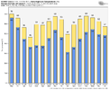
Well, like it or not, every single ensemble member on today’s Euro Weeklies has an official SSWE (Sudden Stratospheric Warming Event) in the Feb 14-15 timeframe.
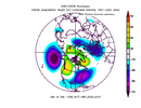
Also, the Weeklies show favorable tropical forcing / MJO from mid-Feb thru late March per VP Anomalies
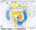
And the pattern response is shown as well. Chilly March or March 1960 incoming
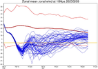
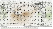
Also, the Weeklies show favorable tropical forcing / MJO from mid-Feb thru late March per VP Anomalies
And the pattern response is shown as well. Chilly March or March 1960 incoming


Last edited:
SnowNiner
Member
Well, like it or not, every single ensemble member on today’s Euro Weeklies has an official SSWE (Sudden Stratospheric Warming Event) in the Feb 16-17 timeframe.
Also, the Weeklies show favorable tropical forcing / MJO from mid-Feb thru late March per VP Anomalies
And the pattern response is shown as well. Chilly March or March 1960 incoming
View attachment 132803
View attachment 132805
View attachment 132804
If it really turns out to look that good, maybe we'd have a chance.
Or, maybe 3 more of this weekends, lol.
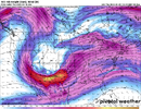
Markers are there for a “big one” for the Deep South . One-two punch with the first system being the primer, deep ridging surface to 850mb with Caribbean feed and a strong broad trough with 500mb vectors out of the WSW, strengthening surface low centered in MO. Definitely one to watch, classic look.View attachment 132785
Looks like things could get interesting late next week from a severe setup.
That blue stuff is too far north. Chilly rains for the SE unless we can get the blue stuff 300 miles farther south.Well, like it or not, every single ensemble member on today’s Euro Weeklies has an official SSWE (Sudden Stratospheric Warming Event) in the Feb 14-15 timeframe.
Also, the Weeklies show favorable tropical forcing / MJO from mid-Feb thru late March per VP Anomalies
And the pattern response is shown as well. Chilly March or March 1960 incoming
View attachment 132803
View attachment 132805
View attachment 132804

