-
Hello, please take a minute to check out our awesome content, contributed by the wonderful members of our community. We hope you'll add your own thoughts and opinions by making a free account!
You are using an out of date browser. It may not display this or other websites correctly.
You should upgrade or use an alternative browser.
You should upgrade or use an alternative browser.
Pattern Fail or Fab February 2023 Pattern Thread
- Thread starter Metwannabe
- Start date
Iceagewhereartthou
Member
26.1 this am! I walked outside and it felt like Februrary and I was completely in shock. So refreshing out there. Enjoy the cool air the next 48 hours guys!
Going to be close, clouds vs max coolingTonight
Lol...true for you. But us to the west will get increasing clouds quicker/longer and will stay just above freezing; or that's at least what they (RAH) think right now.Tonight
Yeah j/k with you, I figured you meant after this cool shot anyway. Whilo knows when but I guarantee you we haven't seen the last subfreezing tempLol...true for you. But us to the west will get increasing clouds quicker/longer and will stay just above freezing; or that's at least what they (RAH) think right now.
Which bojangles?I’m moving to Gatlinburg area. Job offer I couldn’t turn down.
I kid I kid. Congrats.
March 1/2 is looking good right nowYeah j/k with you, I figured you meant after this cool shot anyway. Whilo knows when but I guarantee you we haven't seen the last subfreezing temp
Looking at the updated teleconnections this morning… The NAO is now looking like it is really going to be tanking at the end of the month and as we head into early March and now the AO is beginning to trend towards negative as well… very similar to the NAO trends that started a few days ago. With the MJO heading through low amp phase 8, that’s really going to start muting the SER that will be dominating the next 7-10 days…even with a -PNA.
yeah man just in time to kill off all the premature budding all the trees have been doingLooking at the updated teleconnections this morning… The NAO is now looking like it is really going to be tanking at the end of the month and as we head into early March and now the AO is beginning to trend towards negative as well… very similar to the NAO trends that started a few days ago. With the MJO heading through low amp phase 8, that’s really going to start muting the SER that will be dominating the next 7-10 days…even with a -PNA.
I agree and I noted this yesterday. As nice as next week is going to feel outside, it’s laying the groundwork for major agricultural losses.yeah man just in time to kill off all the premature budding all the trees have been doing
JHS
Member
Thursday looking really warm now. Most places east of the mountains hit 80 with dewpoints as high as 65 in some places.
Avalanche
Member
Any showers/tstorms associated with this?Thursday looking really warm now. Most places east of the mountains hit 80 with dewpoints as high as 65 in some places.
JHS
Member
Will be dry. The gfs now has a 999mb low over the Carolinas Monday the 27th and the flow looks zonal then. Thursday may be our warmest day for a while.Any showers/tstorms associated with this?
ATLwxfan
Member
Looking at the updated teleconnections this morning… The NAO is now looking like it is really going to be tanking at the end of the month and as we head into early March and now the AO is beginning to trend towards negative as well… very similar to the NAO trends that started a few days ago. With the MJO heading through low amp phase 8, that’s really going to start muting the SER that will be dominating the next 7-10 days…even with a -PNA.
It’s going to be interesting though by the looks of things, the northeast and mid Atlantic do better in this scenario. CAD should keep Carolinas cool but GA and points west likely under the ridge even if a bit muted. PNA strongly negative. Now just hoping we can stay dry.
Sent from my iPhone using Tapatalk
Last edited:
olhausen
Member
Something to keep in mind however is that as the MJO progresses into phase8, the likely response of the models is going to be a continued muting of the SER as we go forward.It’s going to be interesting though by the looks of things, the northeast and mid Atlantic do better in this scenario. CAD should keep Carolinas cool but GA and points west likely under the ridge even if a bit muted. PNA strongly negative. Now just hoping we can stay dry.
Sent from my iPhone using Tapatalk
iGRXY
Member

Perfect example of even with a -PNA if you get a nice -NAO and 50/50 combo you can really mute the SER.
iGRXY
Member
At worst we will be able to keep transient periods of above and below average temps to fight off any prolonged torches as we go into March.
ATLwxfan
Member
At worst we will be able to keep transient periods of above and below average temps to fight off any prolonged torches as we go into March.
Probably well above average to average high temps for many of us. The EPS mutes the torch a bit but upper 50’s to around 60 about what you’d expect in early March. Hardly any effects of the SSWE as of yet.
Sent from my iPhone using Tapatalk
rburrel2
Member
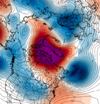
GFS is showing SSWE effects it seems... this is hr 330... also please let's get this and get rid of the PV that's been in that spot for 2 months now.Probably well above average to average high temps for many of us. The EPS mutes the torch a bit but upper 50’s to around 60 about what you’d expect in early March. Hardly any effects of the SSWE as of yet.
Sent from my iPhone using Tapatalk
.


