Hey Larry...Just for fodder, what was the phase of the MJO yesterday?
-
Hello, please take a minute to check out our awesome content, contributed by the wonderful members of our community. We hope you'll add your own thoughts and opinions by making a free account!
You are using an out of date browser. It may not display this or other websites correctly.
You should upgrade or use an alternative browser.
You should upgrade or use an alternative browser.
Pattern Fab-February 2020 The dark age
- Thread starter Ilovesnow28
- Start date
NoSnowATL
Member
Hey Larry...Just for fodder, what was the phase of the MJO yesterday?
5
Sent from my iPhone using Tapatalk
Hey Larry...Just for fodder, what was the phase of the MJO yesterday?
The warmest phase on average, 5!
No wonder the pattern is going back to crap next week (ph 5 mjo)
NoSnowATL
Member
No wonder the pattern is going back to crap next week (ph 5 mjo)
Does look like she is trying to head towards 8 at the end of February.
Sent from my iPhone using Tapatalk
The GEFS is now going for above +6 for the AO!! The record for any day of the year back to 1950 is just over +5.9. History about to be made, folks, as we’re living in special times:
View attachment 33703
That's crazy we were able to score 6" during all of that! Just goes to show, the more we think we know.....The warmest phase on average, 5!
We’ve had huge flocks of sandhill cranes flying north all day. Usually that’s a sign but I’ve seen them head north too early before.
The extremely strong sfc low pressure helped out a lot as a temporary cold air source
That's crazy we were able to score 6" during all of that! Just goes to show, the more we think we know.....
Congrats, wow, 6”! When was the last time you experienced 6”+ and when was the last time Ellijay got at least that much from one storm? I know Dec of 2017 was a big one for many in N GA down to much of ATL area with even more than the 6” for a good number. Then again, that one was pretty historic.
Indeed, it is amazing that with commode-like indices other than the +PNA, no Gulf low, and no unusual cold that a good number of N GA folks got 4-8”, a truly major storm! They’re all unique in their own way but this one was a one of a kind! It is almost as if y’all cheated Mother Nature. ?
People north of 1-20 has seen a good winter so far with 2/3 small events.Congrats, wow, 6”! When was the last time you experienced 6”+ and when was the last time Ellijay got at least that much from one storm? I know Dec of 2017 was a big one for many in N GA down to much of ATL area with even more than the 6” for a good number. Then again, that one was pretty historic.
Indeed, it is amazing that with commode-like indices other than the +PNA, no Gulf low, and no unusual cold that a good number of N GA folks got 4-8”, a truly major storm! They’re all unique in their own way but this one was a one of a kind! It is almost as if y’all cheated Mother Nature. ?
That's crazy we were able to score 6" during all of that! Just goes to show, the more we think we know.....
I just looked at the Ellijay snow history back to 1937-8. It is not filled in for the last 10 years or so. But for 1937-8 through 2008-9, it appears yesterday’s 6” might barely crack the top 10 heaviest single storm list! So, a big deal even up there.
I’m going to check Blairsville next. Their 6”
Looks like it may have barely cracked the top 20 since 1935-6 but am not sure.
Now Dahlonega: also may have barely made top 20 but again not sure.
Last edited:
That Potential CAD system had been trending worse at H5 unfortunately, mainly because the ridge flex, probably another escarpment front end ice event, still time for this to change 
Webberweather53
Meteorologist
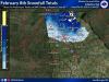
Alright as promised and since many of you asked for this, you shall receive. Here are updated maps for North Carolina, South Carolina, and Georgia plus a regional analysis that stitches together these maps and blends NOHRSC & other analyses from NWS WFOs (like Morristown, TN/MRX). For the statewide maps, I merged NWS Local Storm Reports, CoCoRaHS, mPING, social media, and posts on this forum to construct them. Georgia in particular took longer than both SC & NC to construct, but I hope everyone who was impacted by this storm or watched it from afar enjoys these.


Last edited:
pcbjr
Member
Tic toc ... FWIW ... NWS Jax briefing this afternoon ...

Congrats, wow, 6”! When was the last time you experienced 6”+ and when was the last time Ellijay got at least that much from one storm? I know Dec of 2017 was a big one for many in N GA down to much of ATL area with even more than the 6” for a good number. Then again, that one was pretty historic.
Indeed, it is amazing that with commode-like indices other than the +PNA, no Gulf low, and no unusual cold that a good number of N GA folks got 4-8”, a truly major storm! They’re all unique in their own way but this one was a one of a kind! It is almost as if y’all cheated Mother Nature. ?
Thanks, Larry. We were modeled within the bullseye for almost 2 days so we were really lucky. The HRRR was horrible as it got closer to the event.
We have been in Ellijay just over three years and last year we managed a flurry? The year before, we cashed in nicely for the early December snow and had anywhere from 7 to 10 inches. MBY had 8 inches. The one yesterday was special though. It was like an oasis in a long period of nothingness. I was going for a winter of 01-02 to compare before this happened.
If I recall, the top heaviest in Ellijay was close to 30 inches but get this. It was in October! I bet that was insane!I just looked at the Ellijay snow history back to 1937-8. It is not filled in for the last 10 years or so. But for 1937-8 through 2008-9, it appears yesterday’s 6” might barely crack the top 10 heaviest single storm list! So, a big deal even up there.
I’m going to check Blairsville next. Their 6”
Looks like it may have barely cracked the top 20 since 1935-6 but am not sure.
Now Dahlonega: also may have barely made top 20 but again not sure.
Six Mile Wx
Member
Six Mile Wx
Member
Thanks for this Eric! May I share the image of the GA map to my Facebook weather page? (I'm sure you wouldn't mind, but I would rather ask first.) I'm curious, what program you use to make these maps?Alright as promised and since many of you asked for this, you shall receive. Here are updated maps for North Carolina, South Carolina, and Georgia plus a regional analysis that stitches together these maps and blends NOHRSC & other analyses from NWS WFOs (like Morristown, TN/MRX). For the statewide maps, I merged NWS Local Storm Reports, CoCoRaHS, mPING, social media, and posts on this forum to construct them. Georgia in particular took longer than both SC & NC to construct, but I hope everyone who was impacted by this storm or watched it from afar enjoys these.
View attachment 33733
View attachment 33734
View attachment 33738
View attachment 33737