BHS1975
Member
This is the 3rd Feb torch right on schedule.
Sent from my iPhone using Tapatalk
Would be the forth in a row but last year was 3 above normal so not quite a torch.
Sent from my iPhone using Tapatalk
This is the 3rd Feb torch right on schedule.
Sent from my iPhone using Tapatalk

Rates would definitely help out here for sure .. seen the ensembles try to wrap this little system up .. would be interesting but I won’t put any of my chips in .. mostly cause I ran out of them weeks ago
This looks interesting. Doesn’t appear cold enough outside mountains. But look at that high to the north this thing could trend better.
Sent from my iPhone using Tapatalk
Rates would definitely help out here for sure .. seen the ensembles try to wrap this little system up .. would be interesting but I won’t put any of my chips in .. mostly cause I ran out of them weeks ago
is this an ACTUAL Alberta Clipper? God, I miss those. Usually means transient snow showers and no accumulation, but I'll take it, along with a teen low or two.
This looks interesting. Doesn’t appear cold enough outside mountains. But look at that high to the north this thing could trend better.
Sent from my iPhone using Tapatalk


The CMC did get upgraded ... wouldn’t be surprised if something tried to sneak out at this time period .. we can hope it’s a trend to beSo now gfs/cmc and euro has this second wave also gefs too
This will be our 3rd straight Feb with a stout -PNA.

The last 2 Februarys have had +AO/-NPO (which are strongly correlated to -PNA) were followed by El Nino the next winter, that's not a coincidence.
In light of how persistent & strong WWBs have been since late October, a strong West Pac MJO pulse in late Feb/Mar would be a final nail in the coffin imo for potentially setting off an El Nino in 2020-21.
The GEFS is very enthusiastic obviously but the ECMWF tends to completely whiff on MJO events when initialized near the Maritime Continent.
View attachment 32918
Just glancing at the PNA tables on cpc...that is fascinating looking at past Feb -PNA preceding upcoming nino's. I know nothing is 100% certain but that is stout correlation.
Really I mean I halfway want to chase and I easily could but I'm kind of over this having to go somewhere to see a real snowI saw this coming but someday I'm gonna live in a place where snow happens every year /end rant
View attachment 32920
we couldn't possibly suck for a 3rd straight nino could we? What could change to make next winter even worth tuning into if it's a nino?

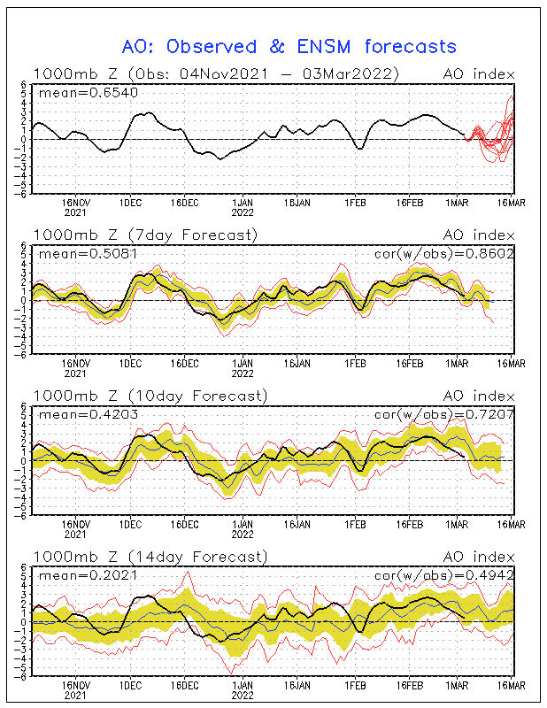
The AO will also be dropping at the same time. If we can ever get a -AO that will be interesting.Check out the models’ forecast for AAM. Note that they’re all rising after midmonth, including even the -AAM biased GEFS almost getting back to 0. The -AAM has correlation with a SER/La Ninaish pattern while a +AAM has the opposite correlation with a Ninoish pattern. SE winter lovers should root for a +AAM to return. The most recent cold spell/retreat of SER was during a stout +AAM:
View attachment 32925

The AO will also be dropping at the same time. If we can ever get a -AO that will be interesting.


I would imagine going from extreme +AO to a -AO would open the door for a good arctic outbreak at some point.I think that’s an all-time record high +AO (back to 1950) being shown there on 2/10 of near +6.0! The current record is just over +5.9 if I’m remembering correctly. It can only get better from there. Meanwhile, let’s see if the Arctic can get colder during this very strong +AO. As this graph shows, it is at its coldest of the season and looks like it may be getting colder. Also, note that the coldest normals aren’t til ~2/24-5:
View attachment 32930
I would 100% chase this.
NAM DUMPS snow in a short amount of time. .4-.5 qpf falls as snow in just 3 hrs with ratios around 12:1. So we are talking about easy 1-2inch hr rates for 5-6 hrs.
NAM bullseyes the area abt 20 miles NW of Wichita Falls with 11inches in 6 hrs. I'd be chasing that.
EURO also zeroes in on the Wichita Falls area. Looks like the place to be.
I would imagine going from extreme +AO to a -AO would open the door for a good arctic outbreak at some point.
Hey, I need you to come in Wednesday on your off day and work. Can you handle that for me?yeah a weather friend messaged me last night and he lives up there so I'm definitely eyeing it... but I wanna see what the models show tonight and tomorrow and that the higher totals are legit(and that this doesn't shift back towards Dallas at the last minute)... but I mean when am I gonna get a setup apparently this good when I'm off work again is the main point here lol
GFS says you better get your flurries this week cause the next opportunity wont come until the 19th and even that opportunity is for the mountains.
Time is ticking and we only have one timeout left.
Yeah this time frame has alot of potential to it. It's getting juiced up on every run and colder. My bags are packedSuprised no one is talking about this, this kinda reminds me of the last event that provided some suprise snow, just need a little bit more support but this ain’t that bad View attachment 32934
Just was texting a friend talking about this one. Looks like it may affect same areas as Friday with more precip to work with. See what the good doc diagnosis is shortly.Suprised no one is talking about this, this kinda reminds me of the last event that provided some suprise snow, just need a little bit more support but this ain’t that bad View attachment 32934
Hey, I need you to come in Wednesday on your off day and work. Can you handle that for me?
Need it to dig more
