Up to 10.56” for the month and that’s probably one of the lower totals in Pitt, areas around FarmVille and Ayden / Grifton have seen a good bit more, as well as in town up through Bethel. Almost 6” of that has fallen in just the last 3 days, picked up about an inch yesterday and 0.64” in the early morning hours today.
-
Hello, please take a minute to check out our awesome content, contributed by the wonderful members of our community. We hope you'll add your own thoughts and opinions by making a free account!
You are using an out of date browser. It may not display this or other websites correctly.
You should upgrade or use an alternative browser.
You should upgrade or use an alternative browser.
Pattern Dry July 2024
- Thread starter SD
- Start date
Shaggy
Member
Cumulus field is building. Tall skinny towers right now but it's juicy out and the coastal areas of SC are erupting so I hope it works up my way.
Yeah I'm actually over 10.5 now and not sure the last time I had that much in a month without a tropical systemUp to 10.56” for the month and that’s probably one of the lower totals in Pitt, areas around FarmVille and Ayden / Grifton have seen a good bit more, as well as in town up through Bethel. Almost 6” of that has fallen in just the last 3 days, picked up about an inch yesterday and 0.64” in the early morning hours today.
- Joined
- Jan 23, 2021
- Messages
- 4,604
- Reaction score
- 15,202
- Location
- Lebanon Township, Durham County NC
I certainly dont have as long of a memory as you do so I'll agreeYeah I'm actually over 10.5 now and not sure the last time I had that much in a month without a tropical system

9.71 for July with 1.57 on 6/30. What gets me about my total is the fact it's not being carried by one of those 5-7 inch days that have been fairly common locally it's just been persistent with today being day 8 of rain.Yeah I'm actually over 10.5 now and not sure the last time I had that much in a month without a tropical system
When I look at the models and see a wetter than normal pattern returning early to mid next week I do start to wonder if we are going to do the super wet pattern with a crescendo of a hurricane. Someone correct me if I'm wrong but I don't remember many direct cane hits on the carolinas in at least the last 20-30 years that has been preceded by drought. It seems like our drought busters were always gulf hits
How many legitimate droughts have we had during the summer months over the last 30 years? And would we be talking in terms of drought? D0 or D3 or more over X period of time? Is there a good/easy way to find out?9.71 for July with 1.57 on 6/30. What gets me about my total is the fact it's not being carried by one of those 5-7 inch days that have been fairly common locally it's just been persistent with today being day 8 of rain.
When I look at the models and see a wetter than normal pattern returning early to mid next week I do start to wonder if we are going to do the super wet pattern with a crescendo of a hurricane. Someone correct me if I'm wrong but I don't remember many direct cane hits on the carolinas in at least the last 20-30 years that has been preceded by drought. It seems like our drought busters were always gulf hits
That’s actually closer to what I’ve been. 9.89” for the month and outside 3.85” on the 12th, it’s basically been 1-1.5” at a time. I also had 2.3” on 6/309.71 for July with 1.57 on 6/30. What gets me about my total is the fact it's not being carried by one of those 5-7 inch days that have been fairly common locally it's just been persistent with today being day 8 of rain.
When I look at the models and see a wetter than normal pattern returning early to mid next week I do start to wonder if we are going to do the super wet pattern with a crescendo of a hurricane. Someone correct me if I'm wrong but I don't remember many direct cane hits on the carolinas in at least the last 20-30 years that has been preceded by drought. It seems like our drought busters were always gulf hits
The 3 that stick out to me are 2001, 2007, and 2011How many legitimate droughts have we had during the summer months over the last 30 years? And would we be talking in terms of drought? D0 or D3 or more over X period of time? Is there a good/easy way to find out?
@Chazwin named the 3 that stick out right off memoryHow many legitimate droughts have we had during the summer months over the last 30 years? And would we be talking in terms of drought? D0 or D3 or more over X period of time? Is there a good/easy way to find out?
As for what quantifies drought, you tell me. What I have learned in the past few summers at this board is there is a broad spectrum of what is drought. That said, for this specific exercise I would use extended BN rainfall or the drought monitor being at D0+ at time of impact.
2007 is the year that really sticks out to me. The drought lasted through the summer months into late fall and I remember that year having so many burn bans I lost count of them all. August was a month where RDU broke high temperature records on seven different days including the previous all time high temperature record of 105 degrees.
Last edited:
JHS
Member
1999 had Dennis and Floyd come in from the Atlantic and bust a bigtime drought in NC, but other than those 2 all I can remember were gulf storms to do it. Jerry in 1995 came up through Florida, and Hannah in 2002 came out of the gulf to bust droughts in this area.9.71 for July with 1.57 on 6/30. What gets me about my total is the fact it's not being carried by one of those 5-7 inch days that have been fairly common locally it's just been persistent with today being day 8 of rain.
When I look at the models and see a wetter than normal pattern returning early to mid next week I do start to wonder if we are going to do the super wet pattern with a crescendo of a hurricane. Someone correct me if I'm wrong but I don't remember many direct cane hits on the carolinas in at least the last 20-30 years that has been preceded by drought. It seems like our drought busters were always gulf hits
JHS
Member
2002 and 2007 come to mind for major droughts. Going back farther 1986 and 1993 were also major summer droughts.How many legitimate droughts have we had during the summer months over the last 30 years? And would we be talking in terms of drought? D0 or D3 or more over X period of time? Is there a good/easy way to find out?
JHS
Member
2011 was not that bad here, especially June. It did get drier later in July and into August. That was a crazy spring for severe weather of course with 1 after midnight major bowing MCS giving parts of the Charlotte Metro and surrounding areas 80+ mph gusts, among many other events.The 3 that stick out to me are 2001, 2007, and 2011
Last night's rain came after midnight so day 8 for me as well.@Chazwin named the 3 that stick out right off memory
As for what quantifies drought, you tell me. What I have learned in the past few summers at this board is there is a broad spectrum of what is drought. That said, for this specific exercise I would use extended BN rainfall or the drought monitor being at D0+ at time of impact.
This June was legit drought, .47 the entire month, corn crops lost, I still have dead spots in my yard where the grass didn't just go dormant it all out died. But yeah we do tend to moisten up a good bit before TC head this way, we love to keep it interesting that's for sure lol
Shaggy
Member
What I find interesting is that there are major totals all across the state from @Metwannabe and at @Downeastnc @WeatherNC and down here in cape fear region. All are over 8 inches and it's not been from one system but just round after round of storms. That's pretty impressive when you look at it.9.71 for July with 1.57 on 6/30. What gets me about my total is the fact it's not being carried by one of those 5-7 inch days that have been fairly common locally it's just been persistent with today being day 8 of rain.
When I look at the models and see a wetter than normal pattern returning early to mid next week I do start to wonder if we are going to do the super wet pattern with a crescendo of a hurricane. Someone correct me if I'm wrong but I don't remember many direct cane hits on the carolinas in at least the last 20-30 years that has been preceded by drought. It seems like our drought busters were always gulf hits
Typically when I see a WPC qpf map that shows area wide huge totals it never pans out but it did this time
- Joined
- Jan 5, 2017
- Messages
- 3,802
- Reaction score
- 6,051
Dry July is certainly not happening here. 8.52" for the month and still raining as I type.
The Dry July thread title has worked well in bringing the opposite juju for those who needed rain. During the winter months I think Flaming February, Toasty December and Scorching January might work well.
CltNative90
Member
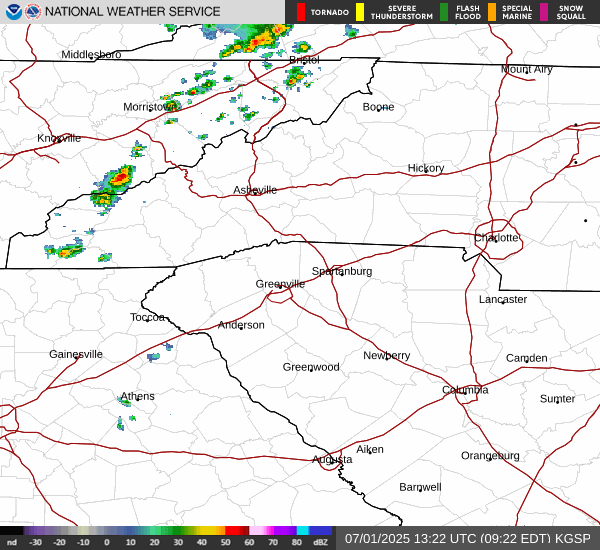
Based on radar alone you’d think this was a tropical system or a cooler season cyclone moving in. Pretty impressive for July. We’ll see if it all can hold together overnight.
On a side note, had two electric thunderstorms yesterday in SW Charlotte, one around 2 pm and another around 8. Also a pretty rare occurrence for the atmosphere to stay that primed this time of year. Typically the first storm would’ve used up all the “juice” as some would say.
Many, myself included, forget that it’s a summer pattern and that your neighbors may score while you’re high and dry. I don’t think I’ve gotten the rain that others in my locale have gotten but that’s life!
Big thunder little rain thus far tonight
HRRRRRR missing bigly on this line of storms right now
Folks down east have been really been getting the rain. If anything tropical develops and pays Eastern North Carolina a visit in Early August there may be some serious flood concerns.
Downeastnc
Member
We went from no rain for nearly a month to rain everyday for weeks now it seems like. Tar River is full and we have a flood watch out for widespread 3-4" and 4-8" possible. A tropical system coming in anytime in the next few weeks would be bad.
PGV could top 15" for the month
PGV could top 15" for the month
I can understand. I haven't done well at all myself until the past week. Not sure of the summer totals but I do know that GSP Airport is only at 3.6 for the entire summer since June 1st. 1.8 in June and only 1.8 this month.Many, myself included, forget that it’s a summer pattern and that your neighbors may score while you’re high and dry. I don’t think I’ve gotten the rain that others in my locale have gotten but that’s life!
Shaggy
Member
Got split again a little. Still got a solid .40 which is awesome especially when no models even showed the rain this morning.Up Early again this morning..
@Shaggy, @lexxnchloe
looks like We have yet another morning Soaker coming in w/in the next couple hours..
However once again just to my NW and SE both had near 1 inch or higher totals. I'd love to understand the dynamics that go into these little hot zones. Is it higher moisture and better humidity for the storms to form on and follow? I'm still winning plenty but I'd love to get one of theose gullywashers one day.

Last edited:
iGRXY
Member
Good bit of rain overnight and it's now make to steady showers again. A complete 180 from a month ago.
- Joined
- Jan 23, 2021
- Messages
- 4,604
- Reaction score
- 15,202
- Location
- Lebanon Township, Durham County NC
I dont know what Florence did to anger the weather gods but stop it

Once the cold front swings through the area and high pressure from the north builds in, the weather should be glorious this weekend for this time of year which climatology wise is the hottest part of the year with highs in the mid eighties and lows in the mid sixties. I imagine there will be a lot of lawn and garden maintenance going on this weekend. I'll be working in my garden this weekend. I might finally have some cantaloupes and watermelons to harvest.
- Joined
- Jan 2, 2017
- Messages
- 1,567
- Reaction score
- 4,282
I was literally begging for rain a month ago and now begging it to stop! Have no idea how much we've had this month as my station got destroyed by a storm a couple months ago.Good bit of rain overnight and it's now make to steady showers again. A complete 180 from a month ago.
Its interesting my area moved up to D2 since last week, but I've had 6 inches of rain this month.
9 straight days of measurable rainfall, 11.9 so far and raining now. Should easily eclipse 12" today. No rain June a foot this month
- Joined
- Jan 5, 2017
- Messages
- 3,802
- Reaction score
- 6,051
Depending on your soil compactness and clay content, it might not be as wet as you think. Once clay soils dry out, it takes time to get them hydrated again. One more month of 4" to 5" of rain ought to get you to D1 and then out of drought by next spring (assuming the fall will be typically dry).Its interesting my area moved up to D2 since last week, but I've had 6 inches of rain this month.
If we are going to see the flood watch verify the next 4-6 hours will be the time to do it locally. Too bad KRAX and TRDU are dead
Another thing on the clay soils is that if it’s very dry and hard like many area were before this wet period started, heavy downpours will often run off instead of being efficiently soaked into the ground. My area has been pretty fortunate this month in that we’ve seen a lot of good soaking rains that have lasted for a few hours and the ground has soaked it in.Depending on your soil compactness and clay content, it might not be as wet as you think. Once clay soils dry out, it takes time to get them hydrated again. One more month of 4" to 5" of rain ought to get you to D1 and then out of drought by next spring (assuming the fall will be typically dry).
JHS
Member
It looks like the area from near Charlotte over to Rocky Mount may very well be going to verify. Advisories already up and training showers and storms there. The tail end of that area dropped more rain here not long ago. Thing are going to dry out some and warm up, but it does not look to be like it was earlier this month.If we are going to see the flood watch verify the next 4-6 hours will be the time to do it locally. Too bad KRAX and TRDU are dead
There are probably going to be a few days sprinkled in over the next 2 weeks where we get some widespread mid 90s maybe upper as this pattern tries to heat release but the general rule is going to be 87-92 most daysIt looks like the area from near Charlotte over to Rocky Mount may very well be going to verify. Advisories already up and training showers and storms there. The tail end of that area dropped more rain here not long ago. Thing are going to dry out some and warm up, but it does not look to be like it was earlier this month.
Stupid maintenance outage always happen at the worst times.If we are going to see the flood watch verify the next 4-6 hours will be the time to do it locally. Too bad KRAX and TRDU are dead
iGRXY
Member
I am over 10" so far this month and it's been raining pretty much everyday for 10 days now.I was literally begging for rain a month ago and now begging it to stop! Have no idea how much we've had this month as my station got destroyed by a storm a couple months ago.