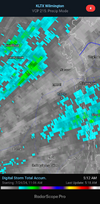
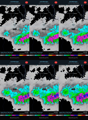
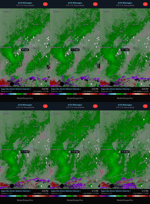
There's a Flash Flood Warning in effect for Wake County. Looking at the radar, I believe that is more related to urban flooding in Raleigh than anything else. The rain started about ten minutes ago at my house near Lake Wheeler and is moderate in intensity now.
-
Hello, please take a minute to check out our awesome content, contributed by the wonderful members of our community. We hope you'll add your own thoughts and opinions by making a free account!
You are using an out of date browser. It may not display this or other websites correctly.
You should upgrade or use an alternative browser.
You should upgrade or use an alternative browser.
Pattern Dry July 2024
- Thread starter SD
- Start date
Getting heavy rain from a thunderstorm now. Due to a combo of potential heavy rain today with very heavy rains earlier this week and last weekend (5” IMBY), a flood watch was already in effect for today/tonight. But it’s already getting lighter.
Last edited:
LickWx
Member
Imagine if we get a nice soaking tropical system . 10-20 inches of rain on top of this! This rain needs to slow down a bitThere's a Flash Flood Warning in effect for Wake County. Looking at the radar, I believe that is more related to urban flooding in Raleigh than anything else. The rain started about ten minutes ago at my house near Lake Wheeler and is moderate in intensity now.
Downeastnc
Member
Yeah at the end of June I would have laughed if you said I would be wishing it to not rain by the end of July.
Already close to a couple of inches today a.d we about to get into this nasty rain band
Already close to a couple of inches today a.d we about to get into this nasty rain band
It kinda reminds me of how the summer of 1999 was… it started out very dry and then got much wetter during July and August and then Dennis and Floyd within a couple weeks of each other.Imagine if we get a nice soaking tropical system . 10-20 inches of rain on top of this! This rain needs to slow down a bit
My wife's name is Debbie and that's the next name on the hurricane list. If the Euro is on to something with a tropical system approaching the southeast coast the first week in August, I can rib my wife about all of the flooding and problems she is causing.
LickWx
Member
Oh gosh now you gon and done it! Mentioning the summer of 99 is gon have @SD bringing up January 2000It kinda reminds me of how the summer of 1999 was… it started out very dry and then got much wetter during July and August and then Dennis and Floyd within a couple weeks of each other.
Shaggy
Member
Everything to my North so far and it's gonna take some time to get this mass of showers to drop down into my area I believe
Looks like the Big Wet will net me a total 2.3 inches.
Thur through Thur. I'll take what I can get.
Thur through Thur. I'll take what I can get.
Enough with the rain already. Went from not having enough to too much.
5.7 for me, 12.55 for the month....heck get me .45 more might as well go big at this pointLooks like the Big Wet will net me a total 2.3 inches.
Thur through Thur. I'll take what I can get.
GoDuke
Member
2.18 in the last week for me. The big wet was a big lie.
- Joined
- Jan 23, 2021
- Messages
- 4,596
- Reaction score
- 15,184
- Location
- Lebanon Township, Durham County NC
Gonna be a beautiful weekend at Sugar Mountain
Shaggy
Member
Big rain off SC coast not being modeled really well so who knows what happens overnight here
Shaggy
Member
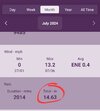
11.5 for the month of July. Hopefully this will ------ the heat as we roll into August. The Hottest part of Summer may be in our rear view mirror this year.
Edit Re_ard . What is with the PC on words now? seriously
Edit Re_ard . What is with the PC on words now? seriously
I got another 1.05 inches of rain yesterday. That puts me over four inches of rain for the week. This pattern is going to give way to some beautiful weather for this time of year this weekend and conditions are going to be close to normal for this time of year for the next five days after that.
A nice little surprise. 1/3 of an inch of rain this morning on the border of North Carolina in South Carolina near Charlotte. I’m not gonna lie. I wish we could keep this pattern.
Sent from my iPhone using Tapatalk
Sent from my iPhone using Tapatalk
I’ve already had 1.09 from that this morning when the forecast wasn’t for anything until after 4pm. I’m up to 10.79” for the month.
Drizzle Snizzle
Member
The horrible drought continues in Metro Atlanta. Cobb and North Fulton are in a Severe Drought according to the latest Drought Monitor.
Shaggy
Member
JHS
Member
Ouch. I have had this kind of thing happen up here way too many times to count. Awfully frustrating.
Technically only June was very dry, July has now been very wet for most. KPDK has had 7.6" of rain this month. KATL 8.84"The horrible drought continues in Metro Atlanta. Cobb and North Fulton are in a Severe Drought according to the latest Drought Monitor.
- Joined
- Jan 5, 2017
- Messages
- 3,769
- Reaction score
- 5,966
That was due to the June dry spell. It will adjust at the next issuance of the monitor. It lags real time observations by a good bit of time.The horrible drought continues in Metro Atlanta. Cobb and North Fulton are in a Severe Drought according to the latest Drought Monitor.
SnowNiner
Member
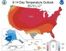
Operation Thaw Alaska is 5 months early. Lol.Oh boy how exhilarating
View attachment 148831
Just hit a trace for the day, that's 10 in a row and 16 of 26 for the month. Pretty impressive imo to do this in July
I just had a sprinkle of rain too. That may be the last hurrah for a while.
https://www.wral.com/story/weather-forecast-Raleigh-Durham-Fayetteville/20635389/
Yes, it has been a rainy July in Wake County.
Yes, it has been a rainy July in Wake County.
Shaggy
Member
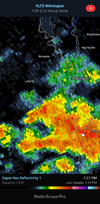
It took a long time for the storm to settle north but I've had almost an inch in 45 minutes or less. Straight dumpingJust hit a trace for the day, that's 10 in a row and 16 of 26 for the month. Pretty impressive imo to do this in July
The really nice dews are currently north of Richmond. It'll take until around this time tomorrow to really drop them off locally but they may be in the upper 50s by evening. Enjoy it Sunday as we are back near 70 Monday afternoon
Shaggy
Member
- Joined
- Jan 5, 2017
- Messages
- 3,769
- Reaction score
- 5,966
I'm not a fan of these maps. .01 degree above normal with 100% certainty results in a lava red color. Quantify it, people!Oh boy how exhilarating
View attachment 148831
already feels great outside, getting out to play golfThe really nice dews are currently north of Richmond. It'll take until around this time tomorrow to really drop them off locally but they may be in the upper 50s by evening. Enjoy it Sunday as we are back near 70 Monday afternoon
Brent
Member
Oh boy how exhilarating
View attachment 148831
Probably our worst heat wave of the summer im so not excited
Although I have heard of a front before mid August
Shaggy
Member
Shaggy
Member
Does anyone know where to find the historical radar that you can go back as far as 30-60 days and see rainfall totals?

