Looks like the pop up storms north of BHM and Tuscaloosa are just splattering on the dry air done.
-
Hello, please take a minute to check out our awesome content, contributed by the wonderful members of our community. We hope you'll add your own thoughts and opinions by making a free account!
You are using an out of date browser. It may not display this or other websites correctly.
You should upgrade or use an alternative browser.
You should upgrade or use an alternative browser.
Severe DEEP SOUTH Severe Weather threat 18-20th
- Thread starter Xtreme Weather
- Start date
-
- Tags
- hail severe weather tornado
- Status
- Not open for further replies.
ForsythSnow
Moderator
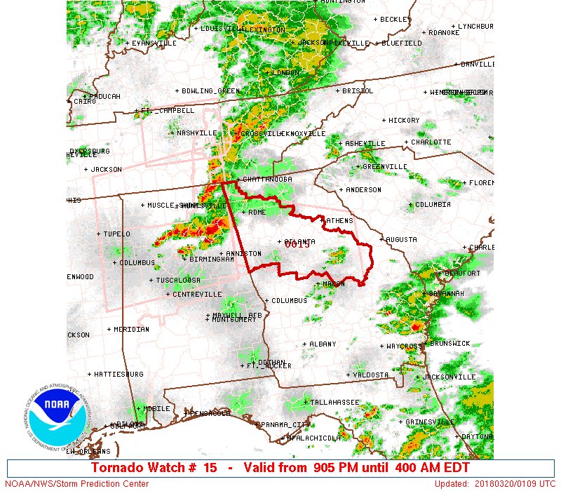
Tornado watch until 4 am just issued for N GA SE.
Going to be a long night.
theskbl17
Member
Not a PDS watch, but a nocturnal threat all the same.
Snow_chaser
Member
I would think as the storms come through west to east, they will cancel the western edge of the watch shortly after? Basically I wouldn’t think western Georgia counties would be under a watch till 4, like the eastern part of the watch area
I'm not gonna ask why, but I can hear a weather siren going off in Goodwater. Once again, not gonna ask.
Well new Tornado warning on southern edge of that beast in Jacksonville AL
https://www.google.org/publicalerts/alert?source=wweather&gl=US&hl=en&aid=4664db8ec862a23a
https://www.google.org/publicalerts/alert?source=wweather&gl=US&hl=en&aid=4664db8ec862a23a
ForsythSnow
Moderator
Yeah they will. Meanwhile, looks like the lead storm is taking on a rotation overall. There is also development north of this to monitor.I would think as the storms come through west to east, they will cancel the western edge of the watch shortly after? Basically I wouldn’t think western Georgia counties would be under a watch till 4, like the eastern part of the watch area
B
Brick Tamland
Guest
Not saying this is a bust, but I know for me personally the last few years I have had bigger storms when I am not under any kind of watch, and most of the time no storms at all when I am under a watch.Severe weather has been busting in the Southeast a lot in recent years.
I've gotta say that James Spann is so much better at covering severe weather than any of the ATL mets.
:weenie:
Not as good as he is at predicting snow!:weenie:I've gotta say that James Spann is so much better at covering severe weather than any of the ATL mets.
Phillip l
Member
From the recent SPC update.
“
Supercell structures are persisting farther north (from the AL/TN
border northeastward), aided by ample deep-layer shear. The tornado
threat will likely be maximized in the near term, primarily near
Jackson Co, AL. A supercell continues to track east here, with a
recent TDS noted from the KHTX radar. However, as these cells push
farther east, weakening low-level instability (and potential
destructive interference from other storms) will likely transition
the threat to primarily hail and gusty winds.”
Probably not in time for me only about 35 miles from centre and JacksonvilleFrom the recent SPC update.
“
Supercell structures are persisting farther north (from the AL/TN
border northeastward), aided by ample deep-layer shear. The tornado
threat will likely be maximized in the near term, primarily near
Jackson Co, AL. A supercell continues to track east here, with a
recent TDS noted from the KHTX radar. However, as these cells push
farther east, weakening low-level instability (and potential
destructive interference from other storms) will likely transition
the threat to primarily hail and gusty winds.”
The damage from the hail is amazing.
skywatcher
Member
James Spann is always welcome to follow my market during sever weather events.I've gotta say that James Spann is so much better at covering severe weather than any of the ATL mets.
Looks like the supercell over Cherokee County is becoming the bookend vortex of the MCS, Webb has been talking about.
Snow_chaser
Member
It’s amazing looking at radar, I don’t see anything between us and Alabama line. That’s 30+ miles and we’re getting thunder and lightning. Is that because of the overall heights of the storm that we can see and hear it from that far, or do I need a better radar lolProbably not in time for me only about 35 miles from centre and Jacksonville
Probably not in time for me only about 35 miles from centre and Jacksonville
skywatcher
Member
The warm front stalling to the south of HSV saved us from most of the supercells. One in NE Limestone/NW Madison counties snuck through.
Tornado Debris signature in Jacksonville
Kimberly
Member
That debris sig looks right over the city of Jacksonville.
Classic TDS in Jacksonville

Sent from my Pixel 2 using Tapatalk

Sent from my Pixel 2 using Tapatalk
It seems like storms are strengthening as they move east ? I wonder if they will get even stronger when they get to GA ?
that TDS in ashville may hit jacksonville as well
Homes damaged in Wellington in Calhoun County.
theskbl17
Member
First tornado warning for GA: southern Floyd and northern Polk counties. Doesn't include Rome but does include Cedartown and Rockmart.
ForsythSnow
Moderator
Floyd and Polk county GA are under a tornado warning now.
FROM THE NWS BMX --- Debris to at least 15k feet with the Jacksonville tornado (now east). Significant tornado. This storm is in a good position along the line and environment-wise to continue into Northern Cleburne Co.
Sent from my Pixel 2 using Tapatalk
Sent from my Pixel 2 using Tapatalk
Phillip l
Member
It’s getting real now. The main tornado in that line now moving into GA has been warned for 165 miles.
Looks like all local Atlanta news stations have immediately gone into severe weather coverage mode with the first tornado warning being issued in GA.
HRRR pretty much nailing this from the runs around 5-6pm. Two or three signatures crossing northern Calhoun County.
jacksonville still not out of the woods yet.. another is knocking on the door
RollTide18
Member
These storms are training like crazy
Kimberly
Member
Jacksonville is fixing to get hit hard again. It looks like a identical path.
Watching Spann in NW tennessee tonight. Being from Bham area I've always thought he was the best. And, it's amazing how far live coverage has come in just the last 5 years or so. The graphics, mapping, and communications between the chasers, the public, and the TV mets is amazing.
I have a feeling Carrollton may luck out. Looks like all the action will be to the north and east.
better hope that cell east of Jacksonville weakens bc it’s headed straight towards Atlanta
From SPC MCD 151
DISCUSSION...Recent radar imagery confirms additional supercell
development and rapid intensification of rotation with storms on the
south flank of the long-lived supercell cluster that has crossed AL
during the evening. This newer development initially suffered less
destructive interference compared to earlier storms, and low-level
hodographs have become more favorable for low-level rotation/strong
tornadoes per regional VWPs. The more moist environment near the
AL/GA border may offset the storm interactions and maintain a
significant tornado threat for another 1-2 hours as the storms
spread into GA.
History says that usually storms weaken when they get to GA. Lets hope history repeats itself.better hope that cell east of Jacksonville weakens bc it’s headed straight towards Atlanta
Snow_chaser
Member
Goodness, tv showing rotation to the north and south of me. Paulding County about to get rocked
- Status
- Not open for further replies.