RollTide18
Member
The Tuscaloosa/Birmingham area may be getting in the action momentarily, whether it's of the severity of what's going on in East Alabama remains to be seen
Jacksonville is getting wiped off the face of the map tonight as at least two (& possibly a 3rd anticyclonic tornado) hit a major university in Jacksonville, AL.
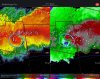
The couplet on that supercell about to move into Haralson, Co. GA looks vicious.
I think with this SE movement we may be clearHeard thunder too and saw a flash light up the sky from an anvil crawler.
I don’t see this thing weakening before it gets to Buchanan. Hope I’m wrong
Poor Jacksonville.
At 958 PM EDT, a confirmed large and extremely dangerous tornado
was located over Coleman Lake And Campground, or 9 miles southeast
of Piedmont, moving east at 40 mph.
This is a PARTICULARLY DANGEROUS SITUATION. TAKE COVER NOW!
As much as history has been kind to the Atlanta metro area, these supercells entering GA mean serious business and aren't likely to weaken too terribly much as they are closing in on the metro.
Supercells typically take right turns so this was a faux-paux on his partGlenn Burns brought up an interesting point not too long ago about these storms unusual travel path (ESE vs. NE or ENE) and how the EF2 Atlanta tornado traveled ESE when it hit, I had actually forgotten about that myself. Speaking of the wedge, I think the wedge may be retreating here anyway, temp/dp has been rising here the past few hours.
Prayers for your kids tonight. And for all of us in the path of this.My stepdaughter is a student at Jax State. Trying to get in touch with her. Son is in Paulding. Tough hours ahead. Seeing lightning here in Sandy Springs now.
Sent from my iPhone using Tapatalk
Just incredible cell crossing from AL into GA
The storm that is hitting me currently has really calmed down. Hardly and thunder or lightning. Heavy rain and gusty wind, no hail at all. Prayers for those hit harder.
I don’t see weakening at allPredictable. Storms are weakening and the tornado threat is dropping as the storms move into more stable air.
Prayers that everything is good with the Stepdaughter.. Paulding so far has not been that bad.. A lot of lightning but not as strong of winds and no hail..My stepdaughter is a student at Jax State. Trying to get in touch with her. Son is in Paulding. Tough hours ahead. Seeing lightning here in Sandy Springs now.
Sent from my iPhone using Tapatalk
I don’t see weakening at all
Prayers that everything is good with the Stepdaughter.. Paulding so far has not been that bad.. A lot of lightning but not as strong of winds and no hail..