NBAcentel
Member


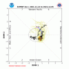
There are many things the Euro is not so good...the MJO being one of them.Here’s the problem with the MJO prospects. Three days ago, the Euro had this forecast, which I called “yummy”:
View attachment 95759
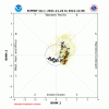
The Euro forecast has since taken a sucktastic turn for the worst and now has this “I can’t get away from the MC” scenario (due to very warm MC I assume) that isn’t “yummy” at all:
View attachment 95760
I’m trying to remember if this area is where the Euro is not so good and that the GEFS might be better. @Webberweather53 and I have discussed this before.
There are many things the Euro is not so good...the MJO being one of them.
Sounds good. I confess I haven't done extensive research on which background states the ECMWF is, by a small statistical significance, too progressive or conservative for all of the various indexes, convective systems, tropical forcing mechanisms, stratospheric propagations, or H5 progressions. However, I have seen it, like the GFS, GEFS, CMC, and its own ensemble suite, frequently reverse on all of those things, especially beyond D5 or so.I don’t think it is that simple. Depending on where the current MJO is, the Euro is better in a good number of scenarios and the GEFS is better in other scenarios. @Webberweather53 knows all about this and it may very well be the case that the Euro isn’t progressive enough when the MJO is in the MC like it is now.
Some of the GEFS really getting excited about a period of possible severe weather along with a significant cold snap back to reality after with plenty of mischief in the middle .. first group of much more exciting ensemble members I have seen in a little whileWell, a little good news for cold lovers is that the HappyHour GEFS doesn’t have as strong/long of a torch following the current cold and when it subsequently cools back to at least normal.
It doesn’t matter if you had the MJO in phase 2, a +PNA that reached all the way to Australia, a -NAO that was the strongest ever seen and covered all of Canada, it would still 33 and rain! It’s just the way it is now! I’m glad I was there to witness January 88!!! Still the greatest snowstorm of my lifetime and I don’t think it will be beaten up here either!Sounds good. I confess I haven't done extensive research on which background states the ECMWF is, by a small statistical significance, too progressive or conservative for all of the various indexes, convective systems, tropical forcing mechanisms, stratospheric propagations, or H5 progressions. However, I have seen it, like the GFS, GEFS, CMC, and its own ensemble suite, frequently reverse on all of those things, especially beyond D5 or so.
Webber might be able to tell you that it has a 51% chance of being too progressive in a 2nd year La Nina, but Rain Cold can tell you that the European model is a hunk of junk at the end of its range.
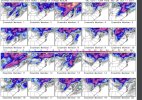
That great Larry! What does the bc gefs indicate with mjo?On a brighter note, the GEFS, which tends to do somewhat better than the Euro when the MJO is in the MC because it is correctly more progressive, is encouraging for potential cold mid to late Dec. Who needs the over-rated King anyway? He’s just a figurehead.
View attachment 95769
That great Larry! What does the bc gefs indicate with mjo?
Grey shading = pant bombPants explosion per Nicky b
The actual mean View attachment 95770
Good news is that the 0Z GEFS looks like it could be similar to the 18Z, which itself was significantly colder than the 12Z and earlier runs.
Some big dog ensembles at thatAnd now I can add the 6Z to the 18Z and 0Z as GEFS runs in which there are only 1-2 AN days through the entire 16 days in the SE US meaning the impressive run of cold domination now has no end in sight at least per the GEFS!!
And with the GEFS suggesting the potential for a favorable MJO for SE cold mid to late Dec, well…..

and while that shallow ridge doesn’t help promote a cross polar flow to bring Siberian air mass into North America, it can help to bring in the cold that builds in NW Canada… as we go further into December that’s cold enough to get winter weatherThe shallow western ridge this fall has been extremely stubborn, like what the southeast ridge use to be
Hi golf, I’m not following your question. What is “bc”?
Your correct fro. When it breaks down though, it may be extremely difficult to flip it back neutral or positive imo.The shallow western ridge this fall has been extremely stubborn, like what the southeast ridge use to be
Why? Looks to be propagating into the ideal phases and out of the MC.That's why we cant get too excitedView attachment 95784
Some people would kill for this look ?Why? Looks to be propagating into the ideal phases and out of the MC.
Only if you moved to TR?I get the fantasy death band️ View attachment 95782
Why? Looks to be propagating into the ideal phases and out of the MC.
A low amplitude MJO is not really something to worry about or get overly excited about. Lots of other pattern drivers at work out there.Goes from phase 6 into the cod. I thought we want to see it in phase 7? Larry, do u see the BC after gefs top right corner? That's the bias corrected I meant earlier
A low amplitude MJO is not really something to worry about or get overly excited about. Lots of other pattern drivers at work out there.
Also, the western ridge may break down for a time, but we may also see blocking develop. There's some pretty good cold air building up over northern North America. Wouldn't take a lot to tap it.
