• Hello, please take a minute to check out our awesome content, contributed by the wonderful members of our community. We hope you'll add your own thoughts and opinions by making a free account!

Pattern December to Remember

I think 1 is good for my area if I remember correctly. I know Larry has posted that snow storm per phase a few times for Atlanta.

The most telling stat imo is the amount of major ATL winter storm activity within the COD:

- ALL 8 major icestorms and sleetstorms since the MJO history starts in 1975 were when it was in the COD! This includes the ATL icestorm that was the Carolina Crusher in 2000.
- Also, 2/11-12/2014 (which was a mix of ZR/IP/SN and I also count as one of the 8 major ZR/IP), 3/24/1983 (heaviest KATL snow since 1/1940), and 1/12-14/1982 (snowjam ‘82).
-So, a whopping 10 major ATL winter storms out of 17 since 1975 were when it was within the COD!
 
Isn't it all really about getting a +PNA? Otherwise, cold will be fleeting at best.

TW
You’ll see research that shows we can get snow in any pattern. But it's going to be hard to get and stay cold with trajectories out of the SW or west. A +PNA is helpful, but like anything else, it can be muted by other things. You can have a +PNA and a mild Canada, for instance. We've certainly seen that before. But, we'd definitely take a +PNA, if it was offered to us.
 
Good que

to many are under estimating the La Niña to begin with … I didn’t expect much this winter from the start

This. I expected one good10-14 day window for us this season given the second-year La Nina. Maybe that window will come the first half of January?
 
No one is canceling winter just trying to pinpoint ? when I think our chances start. I always believe in winter lasting through March if it doesn’t start until February 1st oh well I’m still rooting FOR snow.
 
I would be concerned if we had that big of a temp gradient over the Midwest at the end of the GFS. What's odd is the severe weather threat that comes with it.
 
Depends on your location. Problem with a +PNA is you tend to get exceptionally cold air which means suppression city.

The odds are significantly better with a +PNA than with a -PNA for a Miller A major SE snowstorm (little or no ZR). This allows the best chance for it to be cold enough high up enough in the atmosphere for snow. But the trough axis needs to be to the west to allow for enough moisture for major precipitation and it not be dry cold. But if we’re talking storms where CAD based ZR is a major part of it, that’s different.
 
Last edited:
I'd keep an eye on what's going on just NW of Hudson Bay just west of the ridge poking in from Greenland. Gefs had more consolidation of a real pv lobe there
 
The BAMX viddy a couple pages back explained well I thought why the euro and gfs see things differently over the next 30days. Sounded like they we'll get a better handle after Monday (typhoon movement) . Be curious to see if the 2 models begin aligning more. Hopefully to a colder regime over the eastern conus than what the euro currently believes will happen.
 
I will continue to say that I don’t believe a pattern change to occur until 27th-3rd this is where I think rumblings happen and head towards that pattern change we want for snow … anything before that “should be” torch baring a lucky break with CAD but you shouldn’t prepare for anything fun until early January
 
I will continue to say that I don’t believe a pattern change to occur until 27th-3rd this is where I think rumblings happen and head towards that pattern change we want for snow … anything before that “should be” torch baring a lucky break with CAD but you shouldn’t prepare for anything fun until early January
Than you worry about the January thaw …
 
Than you worry about the January thaw …
The very last few days of December and first week of January is when most folks have been saying the flip to cold could occur. Between now and then warm to normal is expected. I am not worried about a January thaw for at least 2 weeks if the -NAO gets established and the Pacific just improves some it may take awhile to dislodge the cold if it gets established. Nothing in weather is ever for sure but winter in the mid south and the southeast, but may as well look at the positives possibilities when they are there. Most of us can handle the disappointment, there is reason to be optimistic especially for my area I believe. Slightly negative to slightly positive PNA can work for most of Tennessee many times except maybe East Tn.
 
The very last few days of December and first week of January is when most folks have been saying the flip to cold could occur. Between now and then warm to normal is expected. I am not worried about a January thaw for at least 2 weeks if the -NAO gets established and the Pacific just improves some it may take awhile to dislodge the cold if it gets established. Nothing in weather is ever for sure but winter in the mid south and the southeast, but may as well look at the positives possibilities when they are there. Most of us can handle the disappointment, there is reason to be optimistic especially for my area I believe. Slightly negative to slightly positive PNA can work for most of Tennessee many times except maybe East Tn.
Being little sarcastic. Because it’s got freeze first even to consider a thaw lol
 
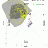
For all the doomsayers out there, here is the Australian prediction of the MJO.
mjo_rmm_daily_20211215(1).png
 
Back
Top