-
Hello, please take a minute to check out our awesome content, contributed by the wonderful members of our community. We hope you'll add your own thoughts and opinions by making a free account!
You are using an out of date browser. It may not display this or other websites correctly.
You should upgrade or use an alternative browser.
You should upgrade or use an alternative browser.
Pattern December to Remember
- Thread starter SD
- Start date
NoSnowATL
Member
.
Whats his track record?If BAMs right, I’ll be dead in about 15 days!??
bigstick10
Member
I find this hard to believe, my yard is a sponge.Yep and long term implication could be problematic, already is to some degree

Ok. I mean this has really been discussed plenty of times, the map is more or less broad brushing areas based off many factors not just recent rainfall. In the SE when so much rain is convective you will certainly have spots with more and other's with less, the map isn't going to pin down each spot like that. Overall, it's just catching up with the actual drought up here, rivers, lakes, creeks, ponds are lowI find this hard to believe, my yard is a sponge.
SnowNiner
Member
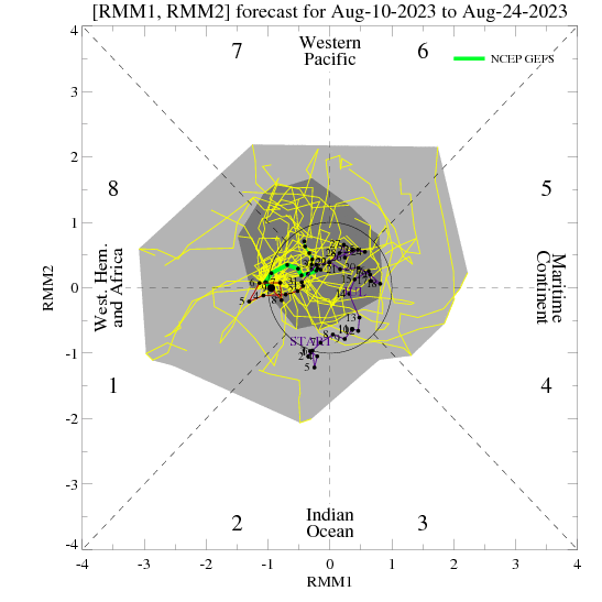
January is in sight! Annnnnnnd.........it's the same as December. ? Seriously persistent Aleutian ridge pattern. Maybe a result of the MJO not moving forward. Really need to have the MJO move and stop messing around in 7 (EPS is worse). Don't think we see much real change in the pattern until tropical forcing switches things up.


Batting 1000, on being wrong!.
Whats his track record?
NBAcentel
Member
Phase 7 mjo is decent in jan if I’m not mistakenJanuary is in sight! Annnnnnnd.........it's the same as December. ? Seriously persistent Aleutian ridge pattern. Maybe a result of the MJO not moving forward. Really need to have the MJO move and stop messing around in 7 (EPS is worse). Don't think we see much real change in the pattern until tropical forcing switches things up.
View attachment 98152
JB says when that super typhoon gets out of the way the MJO will move... ? ?
packfan98
Moderator
Phase 7 mjo is decent in jan if I’m not mistaken

D
Deleted member 1449
Guest
I wouldn't purchase the casket just yet!If BAMs right, I’ll be dead in about 15 days!
D
Deleted member 1449
Guest
This is what I meant by the MJO possibly moving in the wrong direction in the short term. And can we really say that MJO phase 7 is a lock for cold in January?
D
Deleted member 1449
Guest
Either way, I still don't see much of a reason to be optimistic about the next two weeks.
Webberweather53
Meteorologist
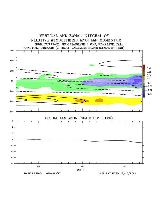
I annotated the GDSM Relative Atmospheric Angular Momentum (AAM) plots to show everyone what I'm thinking/seeing when I look at one of these. The footprint of this past November's Maritime Continent MJO is still lingering in the mid-latitudes in the form of -U/-AAM (easterly zonal wind anomalies). The westerly momentum build-up from the ongoing WP MJO event looks like it's poised to send some of this -AAM (cool colors) sitting around 30-40N, and westerly momentum in the tropics poleward as we enter January. That would create a very favorable AAM distribution for persistent/strong high-latitude blocking in January.

NBAcentel
Member
I’m a fan of this trend 
Webberweather53
Meteorologist
I spy an easterly QBO
If you’ve been seeing some of the posts Webb puts out phase 7 in December but especially January means a bump up in our chances of a winter storm in the SE .. I’ll take my chances thereThis is what I meant by the MJO possibly moving in the wrong direction in the short term. And can we really say that MJO phase 7 is a lock for cold in January?
iGRXY
Member

So far, more west based -NAO and more +PNA.
iGRXY
Member
 Couple things. The track of this is upper level low is about spot on for wintery weather in the Carolinas. Problem is we need more ridging over the lakes and need the 50/50 to trend stronger and slow down. Luckily the GFS is notoriously bad at predicting CAD but this is a close look.
packfan98
Moderator
Definitely a cold pattern setting up on the 12z GFS and seems to match up well with the teleconnections. Let's see if we can get some moisture to go with it.

NBAcentel
Member

At least it would feel like Christmas

iGRXY
Member

Look what happens when you have wall to wall blocking over top. Way more west-based -NAO and -EPO. Other than a quick warm up for a day for those west of the apps (CAD is very dominated here and on this run) we are quite cold.
Cary_Snow95
Member
Cool shot, torch, cool shot, torch on the 12z
iGRXY
Member


GFS might be about to give us a fantasy ice storm for the CAD areas.
But if it was warm you would! Cold is coming in late month- early January!Until euro weeklies. Euro products start picking up on this. Not putting faith into it
iGRXY
Member
Lots of CAD on this GFS run through 300hrs. Artic highs are sliding into the US around this time period now.
NBAcentel
Member
Great setup to get a very deep 50/50 low 

tennessee storm
Member
Not so fast. Wish I couldBut if it was warm you would! Cold is coming in late month- early January!
tennessee storm
Member
Just telling u we got a lot to fix in the pacific for one . Be lucky if we can ever get pna positiveBut if it was warm you would! Cold is coming in late month- early January!
packfan98
Moderator
Seems to be an interesting timeframe on several runs. A piece of energy is able to scoot underneath.

iGRXY
Member
Quick fantasy winter storm on the GFS>
NBAcentel
Member
This is a reason I’m watching Christmas Day-few days after with how chaotic models have been. we could easily trend to sneaking some energy thru, and there’s gonna be a ton of confluenceSeems to be an interesting timeframe on several runs. A piece of energy is able to scoot underneath.
Oh but last year didn’t you say a -pna was good for us. You said you would rather have a negative pna than a positive.Just telling u we got a lot to fix in the pacific for one . Be lucky if we can ever get pna positive
packfan98
Moderator
I'm not mad at where the gfs ended up. Pacific doesn't look bad to me.

NBAcentel
Member
That’s quite the SE Canada vortex, and the west based -NAO trending better over time 
tennessee storm
Member
Oh but last year didn’t you say a -pna was good for us. You said you would rather have a negative pna
Good memory u have. Yes . Keeps pattern being to far suppressed for one in our area . But your talking about cold Frigid weather correct? Because positive pna with a strong negative nao ao both going give the gulf coast your winter storms promise .Oh but last year didn’t you say a -pna was good for us. You said you would rather have a negative pna than a positive.
Winner
Agreed. That’s the type of set up where you could see something kinda pop up only 2-3 days out.This is a reason I’m watching Christmas Day-few days after with how chaotic models have been. we could easily trend to sneaking some energy thru, and there’s gonna be a ton of confluence
No not too cold don’t want dry suppressed, I want winter weather with enough sustained cold to keep it around for a 2-3 days at least. Any I think we may pop a positive pna at some point. I live in north middle tn. I don’t have to have pipe bust cold.Good memory u have. Yes . Keeps pattern being to far suppressed for one in our area . But your talking about cold Frigid weather correct? Because positive pna with a strong negative nao ao both going give the gulf coast your winter storms promise .