Webberweather53
Meteorologist
Ironically the last white Christmas in places like Columbia, SC up thru southwestern Piedmont (SE of Charlotte) was in fact 1935 because of this storm on the 22nd and 23rd.


What exactly qualifies as a White Christmas. I know I’ve seen your map of the 2010 storm and honestly it looks a bit off. Even though the snow didn’t start at my house until about 8pm Christmas night, the ground was covered with between .25-.50” by midnight… I remember letting my kids go out play in it around 11pm just so they could say they had played in the snow on Christmas. Also, you don’t have and accumulations for the 25th in Charlotte or Concord…my parents house, which is just a mile from the Speedway, had 1” by midnight and CLT officially has .4” listed in their records for that day. I know the heaviest snow didn’t get going for CLT metro and SE until 2-4am, but a lot of areas did in fact have the ground solidly covered before midnight.Ironically the last white Christmas in places like Columbia, SC up thru southwestern Piedmont (SE of Charlotte) was in fact 1935 because of this storm on the 22nd and 23rd.
View attachment 98001
What exactly qualifies as a White Christmas. I know I’ve seen your map of the 2010 storm and honestly it looks a bit off. Even though the snow didn’t start at my house until about 8pm Christmas night, the ground was covered with between .25-.50” by midnight… I remember letting my kids go out play in it around 11pm just so they could say they had played in the snow on Christmas. Also, you don’t have and accumulations for the 25th in Charlotte or Concord…my parents house, which is just a mile from the Speedway, had 1” by midnight and CLT officially has .4” listed in their records for that day. I know the heaviest snow didn’t get going for CLT metro and SE until 2-4am, but a lot of areas did in fact have the ground solidly covered before midnight.
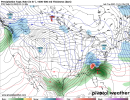
Hey can you or @NickyBGuarantee post what the 12z CFS shows I can’t seem to pull it up on my computerAlso has some mixed precip types across LA, MS, and AR on 12/21/21, next Monday, on the backside of the front. But then, it's the CFS, so I'm not excited right now.
Here you go! It's from pivotalweather's site:Hey can you or @NickyBGuarantee post what the 12z CFS shows I can’t seem to pull it up on my computer

That’s quite the improvement with blocking.
View attachment 98012


Onset iceFGEN band? View attachment 98014


Some big dogs in the weather community taking notice of tomorrow’s winds and storms Up here!View attachment 98016View attachment 98017


Looking yummy to meImo models seem to be trending to a western Us trough handoff pattern to the eastern US confluence type look for Christmas-onwards


I thought we were playing golf on Xmas?! Oh that’s right......that was 10 days ago. Again folks. Nothing past 5 days on modeling is a lock. Total pattern flip from what was being hinted at days ago.Merry Christmas cold lovers View attachment 98025


It's several days out and people are still reeling from last night, but we'll have to keep an eye out on the system this upcoming Wednesday/Thursday too for more severe weather.
It's a similar setup, just a bit further NW.

 ️
️ 


ILM spread. Thanks in advance
Why can't this be correct for once? LOLEuro control is bonkers widespread 30s 40s on Christmas day, a light snow event for nc on the 26th-27th, by the end of the run it has a pv lobe in the lakes, and most days for the region near and after Christmas are well BN. Likely way too cold but fun to see
Euro control is bonkers widespread 30s 40s on Christmas day, a light snow event for nc on the 26th-27th, by the end of the run it has a pv lobe in the lakes, and most days for the region near and after Christmas are well BN. Likely way too cold but fun to see
It's not that far off from the op at D10. Have to at least wonder if the overnight trends are the start of a bigger cold trend, I'm worried it was a blip but we will seeWould love to see that when I come back to NC for Christmas.


.png")
.png")