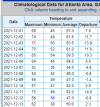
• Hello, please take a minute to check out our awesome content, contributed by the wonderful members of our community. We hope you'll add your own thoughts and opinions by making a free account!

Pattern December to Remember

I have my doubts it gets anywhere near phase 8. Maybe 7 briefly before heading back to crap. I hope I'm wrong but recent years have shown that. And the sst in that region is largely unchanged. Seems as I remember last year or the one before it entered 8 and 1 in a low aplitude and blew through them in a mater of a day or two right back to the bad phases.
Yeah I know we’ll find a way to get into phase 7 for 1-2 days then somehow go back the the COD and recycle a MJO pulse in phase 4-5
 
no where as bad as the cmc lol
5 days ago the gfs was basically showing a record warm December with lows around 70 at times for my area. I do agree though that the cmc is bad and I basically never look at it anymore. I’m happy the gfs is not looking near as warm as a week ago but who knows what it will show in the days to come.
 
How do you know lol

Because Bamwx doesn’t know what they’re doing. I’ve also explained for the last several days why I think this pattern change is going to be slower to arrive

See ?
Here's a nice paper published a few years ago that reinforces my overall sentiment here w/ a slower-moving MJO favoring a more prolonged warm-up in Dec that could last thru the end of the month.

https://journals.ametsoc.org/view/journals/clim/32/21/jcli-d-19-0013.1.xml#fig12

A few key takeaways:

MJO moves ~30% slower on avg during La Nina winters (like this yr) due to how ENSO modulates suppressed convection in
the W Pac (weaker zonal moisture advection/less suppressed convection in La Nina >> slower MJO). Congestus preconditions the environment for deeper vertical heating associated w/ the MJO. Weaker Kelvin Wave activity over the WP during La Nina suppresses pre-moistening, making the environment less suitable for convection east (ahead of) the MJO's convective center.

Sronger Eq Rossby Wave coupling in La Nina contributes to a more profound beta effect >> more retrogression/slower eastward-moving MJO.

Stronger/slower MJO events in La Nina increase the growth rates of anomalous large-scale planetary waves in the subtropics and mid-latitudes (which tend to retrograde westward) and are coupled + evolve together w/ the MJO, helping to slow the MJO's phase speed in La Nina.

Stronger convection over the Warm Pool during La Nina slows the progression of Kelvin Waves (which constitute a large fraction of the MJO) by further offsetting adiabatic cooling that occurs in the ascending (leading) part fo the wave. Chang (1977)


I think you have the right general idea, but I honestly don't believe it'll occur quite as quickly as you're describing. At a minimum, given how this is being forced, it looks like it'll take us no less than 3 weeks to shake off this bad pattern, we'll probably still be right in the thick of it in about 2 weeks time (doesn't mean we can't get a transient cold shot here or there though, and I honestly expect at least one between now and then).

Big reason for that is it takes weeks for the extratropical circulation pattern to change and readjust after getting a large, slow moving MJO event like this one moves across the Maritime Continent and into the Western Pacific, as the planetary Rossby Waves forced by the slower-moving moist convective anomalies become exhibit higher growth rates/become amplified and are harder to break down, this is even more of an issue when you have La Nina and these circulation anomalies are already being enhanced in the lower frequency (90-120 day) means. Normally, the possibility of a -NAO in late December would be a decent bet, but that connection isn't quite as strong during La Nina (although it's more likely when an MJO event is slow moving such as this one, but you're still normally talking at least a week or two after we enter phase 7 for extratropical circulation anomalies to consistently resemble said -NAO, which at least puts us closer to the last week of Dec or so). It's also very possible we never even reach the coveted phase 8/W hem (not uncommon during La Nina when SSTs are too cold to support convection closer to the dateline), which would support more consistent cold in the eastern US.

Just my 2 cents tho.


The updated bias corrected (bc) ECMWF MJO forecast is probably the most realistic one going forward. We're still stuck in the middle of phase 6 through mid-month w/ only ever-increasing amplitude. Maybe if we're lucky the pattern tries to flip during the last week of Dec, but I'm personally leaning towards early January for this to occur.

ECMF_phase_MANOM_51m_small.gif

Not really a coin toss/guess in this case. Ensemble mean patterns are the only thing of value at this range and that's why it was worth posting over an operational run which has zero value beyond day 7-10. Also, as mentioned earlier, this pattern is entirely consistent with what you expect during West Pacific MJO events in December (usually very warm). These MJO events are one of the few phenomena that lend itself to some predictability this far out, because they evolve over periods of weeks, sometimes a month or two (not days as do synoptic weather systems).


Can kind of make out 2 quasi-distinct MJO waves in the Western Pacific in both the analysis + forecast fields through Dec 10 on the CFSv2. The first wave is north of the equator in the NW Pacific, having already developed a few days ago, whereas the second wave forms out of the South Pacific Convergence Zone (SPCZ) in a more classic manner for this time of the year, which is a big reason why you see models like the EPS showing the MJO completing a loop-de-loop in phase 6 through mid-month.

The GFS & CFS try to push the wave out into the Central pacific by the 3rd week of the month, but these models have a habit of progressing MJO waves far too quickly across the Maritime Continent & Western Pacific and I think they're a bit fast once again (& thus too fast w/ the pattern change away from the SE US ridge thereafter). Furthermore, the La Nina will help decelerate this MJO wave as the advection by the background flow (i.e. westerly jet stream) is weaker than usual, and enhanced convection underneath the ENSO standing wave over the Maritime continent will favor increasing amplitude of the MJO (again favoring even more warmth in the east-central US mid-month), which augments the downstream planetary wave pattern, also helping to slow the wave down (as those waves obtain higher amplitudes and tend to retrogress westward in the means). All of this points to an extended warm-up that could last through the 3rd week of the month (dec 14-21) and while we're talking pretty far out, confidence is higher than usual in the outlook during week 2 & may grow more w/ time for later week 2 outlooks once the models initialize a more amplified MJO wave. (which is supported by literature)

chi200.cfs.all.global.3.png
 
Hopefully would mean high amp 7-8 down the road

It translates to a slower moving and more prolonged phase 6 event, and certainly not always high amp 7-8 or even any at all, because the MJO doesn’t tend to move as deeply into the Pacific. Kind of expected this amplification adjustment to occur because we’re in a La Niña and the Euro, while reasonable on timing, tends to undersell these
 
Back
Top