Any research out there that shows ice storms and drought having a connection? Would think with all the dry air and dry surface could trigger some wintery mix storms over cold rain esp E of the mtns. @Webberweather53
-
Hello, please take a minute to check out our awesome content, contributed by the wonderful members of our community. We hope you'll add your own thoughts and opinions by making a free account!
You are using an out of date browser. It may not display this or other websites correctly.
You should upgrade or use an alternative browser.
You should upgrade or use an alternative browser.
Pattern December to Remember
- Thread starter SD
- Start date
Also remember that the AO was positive as well for that stormView attachment 97407
Well since Jan ‘88 was brought up, just thought I would give a friendly reminder of the 5H pattern as one of those “best case scenarios” for widespread SE storm. Interesting in that the EPO was very negative, although there were low heights along the west coast, and a very positive NAO. Some of our best storms are when we have low heights throughout the continent, allowing high presssure to keep storms suppressed and also allowing energy to easily ride underneath it from west to east.
Ground temps?Didn’t realize the EPS Control had a climo area CAD ice storm View attachment 97408View attachment 97409
packfan98
Moderator
More excellent work by BAMWX. Their forecast is laid out clear and concise.
Myself, I would not expect much of a chance of snow except in the mountains as the storm track could favor inland paths
Quick Question. How do you get access to these videos? Are they behind a paywall? I don't see them on the website, twitter, or youtube page.
NBAcentel
Member
This doesn’t hurt the chances of a -NAO 


bigstick10
Member
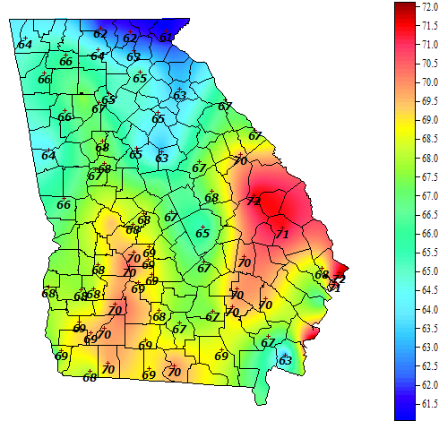
Fog and swizzle in ATL, classic wedge, but only 49-53 degrees...
Last edited:
These past few days have really been winter like
Fog and swizzle in ATL, classic wedge, but only 49-53 degrees...
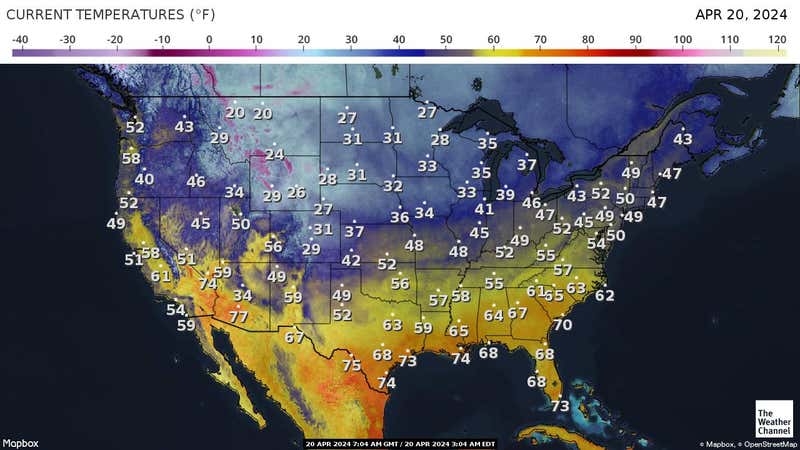
God bless Texas...
bigstick10
Member
I'm sorry, but you can have that ...Dec 10th ridiculous..God bless Texas...
The euro control was epic heading into Christmas then the wheels kind of fell off
SnowNiner
Member
You are correct… the problem with Miller As for CLT metro is just how sharp that cut off is on the NW edge. You can go from 4-6”+ to nothing in a matter of 10-15 miles, and usually CLT metro is on the wrong side of that. Every now and then a January 2002 will happen, but I would much rather take my chance with a Miller B
I think the ones that usually do work out for CLT are kind of a hybrid. They're Miller B's maybe technically, but they dig really south and transfer to our south off the coast taking almost a Miller A track. Those do ok sometimes. But true definitive Miller Bs that cut and transfer. Nope, not my cup of tea. Nope nope. ?
Dewpoint Dan
Member
It's not just Texas that's baking. It's near 80 in Georgia also.I'm sorry, but you can have that ...Dec 10th ridiculous..
NoSnowATL
Member
CAD. It can help and hurt.It's not just Texas that's baking. It's near 80 in Georgia also.


pcbjr
Member
new screen saver ... ?
- Joined
- Jan 5, 2017
- Messages
- 3,806
- Reaction score
- 6,062
I don't know, the "delta" maybe showing us a trend of rising heights on the west coast and falling heights over the northern plains. A sign of better things to come??Meow we're probably not gonna get a big snowstorm underneath a 582 decameter ridge. ☹
- Joined
- Jan 5, 2017
- Messages
- 3,806
- Reaction score
- 6,062
Valdosta is barely GA, more like FL. The wedge has the northern part of GA in the 50's. That looks to hold into the night. I'm curious to see how fast it erodes.It's not just Texas that's baking. It's near 80 in Georgia also.
bigstick10
Member
Valdosta is barely GA, more like FL. The wedge has the northern part of GA in the 50's. That looks to hold into the night. I'm curious to see how fast it erodes.
Georgia Weather - Automated Environmental Monitoring Network Page
University of Georgia Weather Network
 weather.uga.edu
Dewpoint Dan
Member
Your forecast low tonight is 60 which is warmer than your current temp !Valdosta is barely GA, more like FL. The wedge has the northern part of GA in the 50's. That looks to hold into the night. I'm curious to see how fast it erodes.
bigstick10
Member
Area Forecast Discussion
National Weather Service Peachtree City GA
230 PM EST Fri Dec 10 2021
.SHORT TERM /Tonight through Saturday Night/...
It's a very murky and gray afternoon as a CAD wedge remains
entrenched at the surface across north Georgia. As usual, the wedge
has been slow to erode from southwest to northeast, but the wedge
front will make gradual northward progress from this evening into
tonight. Thus, temperatures will be on a non-diurnal warming trend
overnight, gradually warming across north Georgia as the dammed
surface airmass erodes through Saturday morning. Within this regime,
low clouds and patchy fog can be expected through the overnight
hours with a few overrunning light rain showers as well, mainly
north of the warm front in north Georgia.
- Joined
- Jan 5, 2017
- Messages
- 3,806
- Reaction score
- 6,062
I'm always confused by why the NWS does this. I'm assuming that their "low" will be anticipated at 11:59 am. They should make "night" start at sundown and then give the lowest recorded at that time. CAD is often slower to diminish than forecast around here.Your forecast low tonight is 60 which is warmer than your current temp !
Probably the first time I've seen the eps mean with a high in the 40s in the long term in a while.png")
Brent
Member
God bless Texas...
If I wanted to wear shorts in December I'd live in Miami ?
At least it did unexpectedly rain a little earlier
Likewise, I hate it when a late night cold front passage means the high occurred at midnight. So misleading when looking back at daily highs and lows.? JMO.I'm always confused by why the NWS does this. I'm assuming that their "low" will be anticipated at 11:59 am. They should make "night" start at sundown and then give the lowest recorded at that time. CAD is often slower to diminish than forecast around here.
NBAcentel
Member
Cold rain cad in our futureProbably the first time I've seen the eps mean with a high in the 40s in the long term in a whileView attachment 97422
NoSnowATL
Member
Yes temp will rise as the front moves in. s windsYour forecast low tonight is 60 which is warmer than your current temp !
I'll take it.Cold rain cad in our future
Shorts weather? Like you like?Oh man if we can retrograde that trough more into the pacific, cut it off and get a western ridge to boot with the -EPO View attachment 97402
NBAcentel
Member
Empty chair ? Like you have ?Shorts weather? Like you like?
“Merry torchmas”Probably the first time I've seen the eps mean with a high in the 40s in the long term in a whileView attachment 97422
Why you mad bro? I’ve already gotten more snow by accident, than you’ve had in the last 5 years!Empty chair ? Like you have ?

NBAcentel
Member
You getting South Carolina treatment with good snow climo !! HilariousWhy you mad bro? I’ve already gotten more snow by accident, than you’ve had in the last 5 years! View attachment 97425
If I wanted to wear shorts in December I'd live in Miami ?
At least it did unexpectedly rain a little earlier
And if I wanted accumulating snow or below zero temps, I'd live in Minnesota.
Can't have everything we want.

Brent
Member
And if I wanted accumulating snow or below zero temps, I'd live in Minnesota.
Can't have everything we want.
That's alright enjoy it because we all know it won't last
Fort Worth already hinting
Eventually it does look like some colder air
will make a surge southward with some rain chances, it may just be
delayed beyond the current 7 day forecast period.
You almost can, if you live about 3-4000 feet in the NC mountainsAnd if I wanted accumulating snow or below zero temps, I'd live in Minnesota.
Can't have everything we want.

Whamby thread. Thanks
Hey fro do one of those run to run change things here .. 18z looking quite better I think 
Snow in Laredo on the gfs lol