You mean Midwest and southwest.....??Agreed. Need to start a mid west wx blog for Webb and tarheel
-
Hello, please take a minute to check out our awesome content, contributed by the wonderful members of our community. We hope you'll add your own thoughts and opinions by making a free account!
You are using an out of date browser. It may not display this or other websites correctly.
You should upgrade or use an alternative browser.
You should upgrade or use an alternative browser.
Pattern December to Remember
- Thread starter SD
- Start date
Stephenb888
Member
The end of the 6z gfs was getting to where I would like to see us go for the 2nd half of December into early Jan. Its not quite there and it's not a beauty at D16 but it's baby stepsView attachment 96475
The end of the gefs was moving in that direction as well. View attachment 96476
The end of the eps is getting there tooView attachment 96477
Stephenb888
Member
So wait...are we about to have a 2nd summer?
ICON much colder vs 12z
LukeBarrette
im north of 90% of people on here so yeah
Meteorology Student
Member
2024 Supporter
2017-2023 Supporter
Nearly just gave my neck of the woods in Roanoke a snowstorm. WeirdICON much colder vs 12z
And the GFS stays with SER response it’s either really right or really bad but if it ends up being right for at least that December 7-10 time period .. it will be superior to all the other models .. if not .. this model is so trash ?
If y’all ever want to see snow again, I wouldn’t push me out! ??Cool. Southernwx forum correct? I mean it’s some cool wx history but post this on the Midwest forum. Mods please delete.
L
Logan Is An Idiot 02
Guest
Wow I’m thinking my prediction may be right. Pushing 80 in the heart of December?? For several days? Wow this is insanity. This may need up being warmer than the December of 2015. 
L
Logan Is An Idiot 02
Guest
62 imby for a low lol. This will be a December to remember except for the folks that are infatuated with cold weather 
When I was living in uptown 3 years ago it snowed in December about 3 inches but I think the cutoff was South Park...Ive never seen more than a trace of snow here in December (1995-2001, 2012-2021). I may be off in the 90s, can't remember exactly. Probably different for people north of the wall.
Brent
Member
GFS be on something tonight. It must have missed the memo about heat
Yep, heat misers go brrrrrrrrrGFS be on something tonight. It must have missed the memo about heatView attachment 96573

Wrong we will most certainly remember if these warm temps verify .. it’s like if someone attempted to murder you, you would remember that event … that will be December 2021 if these temps verify … at the end of the day it’s always interesting to feel weather outside during a time when you shouldn’t be feeling that weather .. so although it sucks it will be interesting .. I wonder how fires would deal with this62 imby for a low lol. This will be a December to remember except for the folks that are infatuated with cold weather View attachment 96572
Let’s play this game again 


SER finally wins out on the CMC by the end of the run .
CMC also with the upgrade at 12z earlier today so that’ll be interesting to see how it does going forward


DT is all in 

tennessee storm
Member
Key word is here IF…DT is all in View attachment 96582
Not saying he'll be wrong but you have to realize these guys that run paid sites have to tell people what they want to hear or they fear they'll lose subscribers. I hope he is right but we've seen these MJO forecasts for a couple years now going to favorable phases and end up staying in the Maritime continent. In other words I'll believe it when I see it when it comes to phase 7, 8 or 1 during winter.DT is all in View attachment 96582
D
Deleted member 1449
Guest
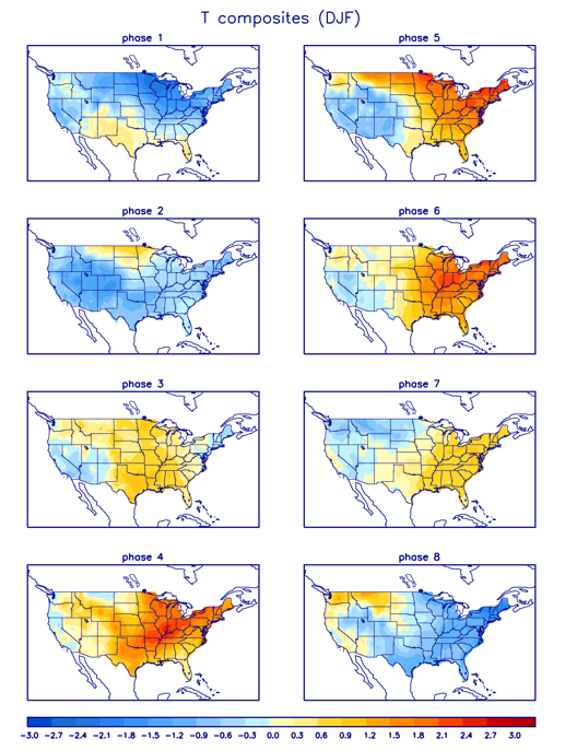
I'd like to know DT's reasoning for phase 7 meaning cold for the east. That is not the case according to this:
NBAcentel
Member
This is a mean…. Insane
20-25F AN


20-25F AN
Big severe weather on GFS! I’m ready for that
Some of my biggest snows have came on the heels of warm weather. 60s one day foot of snow the next.
I think Webb showed yesterday a December only composite that shows phase 7 in December is actually favorable for cold, However he said that the LaNina would slow the response, which is why he’s leaning toward late December/early January before we see a favorable pattern againI'd like to know DT's reasoning for phase 7 meaning cold for the east. That is not the case according to this:
Webberweather53
Meteorologist
The significant cold anomalies don’t appear in the east until phase 8. Phase 7 basically yields a stereotypical La Niña pattern with cold in the northern Rockies + upper Midwest.I'd like to know DT's reasoning for phase 7 meaning cold for the east. That is not the case according to this:
Webberweather53
Meteorologist
There’s no signal in the SE US in the means for phase 7 NDJ. It’s only conducive in the northern plains and Rockies. We’ll have to wait a little longer most likelyI think Webb showed yesterday a December only composite that shows phase 7 in December is actually favorable for cold, However he said that the LaNina would slow the response, which is why he’s leaning toward late December/early January before we see a favorable pattern again
bigstick10
Member
This is just SAD, Major Depressive Disorder with Seasonal Pattern.
 www.weatherforyou.com
Atlanta Georgia Extended Weather Forecasts - WeatherForYou.com
Atlanta, GA, extended weather forecasts
www.weatherforyou.com
Where?Big severe weather on GFS! I’m ready for that
If it’s the one about 160hrs out, it’s more like “ehh”.
NBAcentel
Member
There’s several setups per the GFS but I haven’t looked deeply into them at all, but with a -PNA/+NAO the SE is more prone to severeWhere?
If it’s the one about 160hrs out, it’s more like “ehh”.


L
Logan Is An Idiot 02
Guest
Wouldn’t shock me. We will get a snow after being 70 for 2 weeks and it won’t stick lolSome of my biggest snows have came on the heels of warm weather. 60s one day foot of snow the next.
Webberweather53
Meteorologist
Spoiler alert: he won’t
Honestly ground Temps get way over hyped never been a problem for me or sun angle...Wouldn’t shock me. We will get a snow after being 70 for 2 weeks and it won’t stick
Yeah I went back and looked at your earlier post and saw that it was phase 8. I’m still trying to learn more about the different MJO phases and what they mean at certain times of the yearThere’s no signal in the SE US in the means for phase 7 NDJ. It’s only conducive in the northern plains and Rockies. We’ll have to wait a little longer most likely
6z GFS and Espeacilly 0z Canadian honking for Ice next Wednesday:

0z Euro. Cant access Frzng Rn. This 10;1 Clown shows frzng rn as snow most likely

Cold Rain, Any Rain will be welcomed; Bet it shows less qpf as time approaches

Cold Rain, Any Rain will be welcomed; Bet it shows less qpf as time approaches
The system on the euro is a great cold rain maker that we really need. Maybe some onset frozen/freezing in the classic CAD areas
Webberweather53
Meteorologist
All 3 major ensembles 5-day mean temperature anomalies through mid-Dec
?????


?????
I just noticed the euro actually has 3 rain events with the 3rd firing up at D10. Wouldn't erase the dry anomalies but would certainly help recharge the water table and stream flows. This would likely be the highest 10 day rain totals for a good part of the state since probably early august (2).png")