accu35
Member
2 runs in a row SER. I bet 12z will be totally different.
This run may be right and a trend, but ive seen this show to many times before, where eventually everything bleeds east in time. And the southeast would see and winterstorm of some such. Who knows.6Z = SER
Lol, still good ways off. Anything can change. I believe today will be some changesLet’s hope. Can’t stand the thought of torching through Christmas.
Yes, there is certainly a good many days to go before we get to the final solution. Anything is still on the table at this point.This run may be right and a trend, but ive seen this show to many times before, where eventually everything bleeds east in time. And the southeast would see and winterstorm of some such. Who knows.
Tell that to the EPS and GEFS. Both look ugly this morning.Let’s hope. Can’t stand the thought of torching through Christmas.
Tell that to the EPS and GEFS. Both look ugly this morning.


That's one positive! Hopefully, models are just playing catch up!The good news is the GEFS and the EPS still tank the EPO

The good news is the GEFS and the EPS still tank the EPO
For my lack of understanding, does this imply at all the SER currently being modeled is too strong?That's one positive! Hopefully, models are just playing catch up!
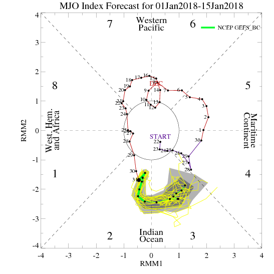
Great post. You said a few days ago that you thought JB and others were a week too early with the cold east idea . As of now it looks like you are spot onUnfortunately the GFS/CMC suite didn't hold onto the trend of diminishing the SE ridge. While those trends were encouraging, they actually don't line up with the MJO phase 7, > 1 amplitude analogs. Now it appears the GEFS (left), GEPS (right), and EPS (not pictured) all support a period of SE ridging intensifying, which fits in well with the MJO analogs for a strong phase 7.

So for now, it appears the guidance may be catching on to the right ideas. As of now, I would favor the big Arctic front not making it into the southeastern U.S., with the likely battle ground being somewhere near the TX/AR/western TN zone with a big ice storm just on the other side of wherever it sets up.
Moving forward, hopefully the MJO is going to continue to progress to the more favorable Phase 8 and 1 regions. For whatever reason, it appears the oft-superior European MJO forecast hasn't been released the past couple of days, but through 12/12, there was strong agreement in the MJO continuing to progress into favorable Phase 8.
The latest GEFS also gets it there, but not until 12/27. Accounting for a typical response lag time of 7 days, we wouldn't expect to see the pattern begin to really respond until after New Years.
So it does appear that the pattern may not be favorable for wintry weather for much of the remainder of the month, but there is still potential for a pattern reversal by the end of the first week of January, *IF* the MJO forecasts are correct.
Bottom line, I wouldn't get too hung up on those ice storm runs of the GFS, because it's possible those are gone for good, of course knowing the long range GFS the 12z will come back only to lose it, come back, lose it, come back and then finally lose it for good once we get inside of the model truncation window.


Thanks for sharing the Nina-specific MJO graphics! I'd still take my chances with Phase 8!
Great post. You said a few days ago that you thought JB and others were a week too early with the cold east idea . As of now it looks like you are spot on

Sent from my SM-J320VPP using Tapatalk
You make several good points. I noticed the bias-corrected GEFS MJO forecast actually does stall out in Phase 7, supporting what you're saying here. It does appear whatever is driving this activity is beginning to have an impact on the pattern, and if it is simply an enhancement of the background state and doesn't progress, well then, that is not going to be fun.

Well for us here in the Midlands of South Carolina we didn’t see anything but a damn cold miserable rainTo be real about things, most of us have already scored last week. I heard over and over if we can get 1 snow then will call it the winter, LOL!! We all know we want more, its the love and passion inside that craves for more. This is a very addictive and you have to really love weather to follow every modle run. So im bless to have an early snow and for that im fine, but a big part of me still wants one more.


Sucks like bricksWell, this sucks. The Southeast Ridge is such a thorn in our side.
You and I both saw like 5 times our average snowfall so we have no room to complain about any warmth or lack of snow the rest of the winter.Sucks like bricks
Way too soon to say that.Looks like Shane was right and that was our only storm of the winter thanks to the NINO/SER.
Sent from my iPhone using Tapatalk
I tend to agree with you. This was the patterns leading up to two of Raleigh's biggest snow storms. We have a way of getting big events in Nina's for whatever reason.Way too soon to say that.

