Webberweather53
Meteorologist
Euro is nice and chilly after this massive shot of arctic air out at day 9. Lows in the upper 10s and lower 20s for most on the board...

I just started ignoring 6Z. It always looks the worst for this system. 12z will be new data too, so I'll base trends at 12z versus 6z. The runs overnight once more sounded and looked great.6z GFS looks meh. It's just one run, but verbatim, looks like cold shots, warm up, frontal passage, cool down, repeat
I’ve been reading for years but don’t post very often. I do have a long term question though. Anybody have thoughts on whether the cold, stormy pattern will hold through Christmas into the new year?
Perfect! Right in time for our next storm! Grain of salt/ GFS cold bias in longer term!Omg, look at that bitter cold coming down into the Midwest around 12/13!!!


Hard to really see on my phone but verbatim it's looks just cold and dry for now. Pac ridge placement to far east? Or too much northern stream?12z gfs should be interesting in a few as long as the energy does not get held up in the SW
Perfect! Right in time for our next storm! Grain of salt/ GFS cold bias in longer term!


Right out the Gulf, too.Here it comes...
View attachment 1786
That high to the N, no Great Lakes low, awesome! The storm should be known as "The One"Here it comes...
View attachment 1786
The 12z gefs is gonna be loaded
Nice hopefully the eps has the same general idea in a few hoursNoticed several members have a southern US slider or mid-Atlantic centric hit w/ fringe snow & ice down to I-40 around that coveted day 11-12 period


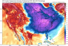
So IF there is any snow cover around oh boy.... insulate those pipesEuro holding serve on another arctic blast in the middle part of next week
View attachment 1797
Look at that cold S of Florida, down to Cuba! That would be very impressive anomalies that far South!!Euro holding serve on another arctic blast in the middle part of next week
View attachment 1797


Agreed, but just prepare. Once it breaks down and we flip it's gonna be UGLY. hopefully that wont happen till mid January . We need to score sooner vs laterI really like how stable the cold pattern continues to look on virtually all of the models through D10. Obviously, there will be some waxing and waning of the intensity through the balance of the month, but it would certainly be nice to continue to see the PNA ridge and ridging over the pole and into Greenland remain steady in the means as we head into January.
That's probably right. But I'm starting to think this just *might not* turn out to be one of those common "winter is over" winters after we flip. I certainly don't expect wall to wall cold, but we're off to quite the surprising start, and I'm starting to think this might be one of those winters that ends up leaving everyone befuddled by its propensity to get cold in the east.Agreed, but just prepare. Once it breaks down and we flip it's gonna be UGLY. hopefully that wont happen till mid January . We need to score sooner vs later
Agreed, but just prepare. Once it breaks down and we flip it's gonna be UGLY. hopefully that wont happen till mid January . We need to score sooner vs later
That's probably right. But I'm starting to think this just *might not* turn out to be one of those common "winter is over" winters after we flip. I certainly don't expect wall to wall cold, but we're off to quite the surprising start, and I'm starting to think this might be one of those winters that ends up leaving everyone befuddled by its propensity to get cold in the east.
That's probably right. But I'm starting to think this just *might not* turn out to be one of those common "winter is over" winters after we flip. I certainly don't expect wall to wall cold, but we're off to quite the surprising start, and I'm starting to think this might be one of those winters that ends up leaving everyone befuddled by its propensity to get cold in the east.
That's probably right. But I'm starting to think this just *might not* turn out to be one of those common "winter is over" winters after we flip. I certainly don't expect wall to wall cold, but we're off to quite the surprising start, and I'm starting to think this might be one of those winters that ends up leaving everyone befuddled by its propensity to get cold in the east.
Not all of Feb 2011 was warm. The first two weeks were pretty cold I believe and it even snowed. Then once mid Feb hit, it got warm fast and stayed warm.Best case is probably a less intense version of 10/11 (which is an analog that gets tossed around a lot however). Cold early but once the door slammed, February was very warm. But what was left in it's wake is one of the best winters in recent memory.
Webb,EPS weeklies are below normal right on into the 2nd week of January, can see signs of the classical NINA winter pattern progression trying to catch up with us by mid month, but with a huge ridge over NE Siberia and Alaska, North America would continue to get seeded w/ cold air...