BHS1975
Member
At least the Aleutian low is persistent keeping the pacific air from flooding Canada.
Yeah, agree. I'm not trying to be negative. I'm just tired of seeing the same thing every year. And as we get closer in, starting to see depictions of the MJO hitting the wall...again...is frustrating.this is bringing back some old memories. It’s way too soon to know what the pattern will be at new years but I think it’s what we’re all keeping an eye on. I like to see either the EPO or AO go negative around January 1. Preferably both. Give me my cold first then we can worry about the snow around the second week of January.
After this blockbuster cold pattern yall have just had, the cold has to re load! PatienceBetter score while we can. Euro AI moving toward an ugly pattern out in time. Fits the MJO progression of stalling out in unfavorable phases, as usual in winter. CFS moving steadily in a less favorable direction also for January. At this rate, we're going down the same path as every other winter in the last few years: A few cold shots, followed by crap for days/weeks.
Hopefully, all of that is wrong. But it's not pleasant to see, particularly since there's been an expectation of happy happy joy joy for January. Not feeling the vibes on that yet, though. But maybe it's just PTSD.
View attachment 155872View attachment 155873View attachment 155874
I’ve always said this, but @Rain Cold is just a better weather forum version of myselfYeah, agree. I'm not trying to be negative. I'm just tired of seeing the same thing every year. And as we get closer in, starting to see depictions of the MJO hitting the wall...again...is frustrating.
I know it's not the be all end all, but the pattern starting to show up in the long range (which I know it's a low skill time frame in terms of predictability), correlates with P6 climatology. It's just frustrating that this seems to happen every year no matter what ENSO state or other background state we're in. It's the same result in the east and southeast.
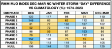
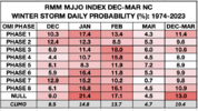
Here's how the ERA-5 Outgoing Longwave Radiation (OLR) MJO Index (OMI) shakes out for NC winter storms since 1940. Looked at (& had to dig up) any winter storm that produced measurable snow east of the mountains or a glaze of ice.
First table here are the daily probabilities of a winter storm, sorted according to ENSO phase. It's actually crazy to see a 20% daily chance of a winter storm during cool neutral ENSO & phase 1 OMI (Western Hemisphere convection).
Phases 4-5-6 of the OMI MJO index tend to be unfavorable overall, while 8-1-2 are generally conducive for wintry weather.
There's also some ENSO sensitivity to these favorable OMI MJO phases. Phase 1 (western hemisphere convection) is better in cold ENSO (like this year), while Phase 2 (Indian Ocean convection) is more favorable in El Niño.
View attachment 155796
This is what the differences look like compared to climatology.
View attachment 155795
View attachment 155793
Here are the total day counts by ENSO phase:
View attachment 155794
https://psl.noaa.gov/mjo/


Despite the low probability, with a western ridge that tall this is always a possibility, even if it’s still low at this range.
i think it's low probability for us, but the gfs has been pretty insistent that an unorthodox meteorological event is going to happen and however that manifests is going to be high impact for soemone. could be us.Despite the low probability, with a western ridge that tall this is always a possibility, even if it’s still low at this range.
From what I can see on my phone, looks like the trough stays positive tilt too long.View attachment 155883
Dang, you would think this much energy would give quite some remarkable surface features on the GFS
This. We always seem to lose our digging mechanism when it counts. Usually via a wave crashing into the pacific NW. This is just something I’ve observed over the years. It’s hard to get that PNA in your favor and it’s even harder to hold it there long enough for a wave to dig to the correct latitude. It seems to get harder every year.From my eyes.. the flow is too fast for magic to really happen. It’s so much harder for timing to be right when energy is moving at break neck speed.
GFS was nice but the ensembles are meh. I don’t see this pattern delivering unless we can find a way to slow things up a bit.
Best case in a pattern like this is you can get an upper level low quick diving down and you can get some broken mountain containment stuff (which can certainly be fun) but it would be an isolated few that get in on the action.
Regardless it looks to at least be cold leading up to Christmas and that’s always a good thing to feel like Christmas when it is Christmas. I think if you’re dreaming of a white Christmas .. you may have to keep dreaming lol
Fixed that for ya Jimmy! I think anyone that has lived long enough in the South remember these snow droughts. It only takes one good one to catch up on the law of averages (We are due a good one!) Pulling for a good old fashioned Miller A to deliver the goods in January!This. We always seem to lose our digging mechanism when it counts. Usually via a wave crashing into the pacific NW. This is just something I’ve observed over the years. It’s hard to get that PNA in your favor and it’s even harder to hold it there long enough for a wave to dig to the correct latitude.It seems to get harder every year.Living in the south, it's threading the needle just about any given year.
December 1993 was an interesting month in NC
View attachment 155884
View attachment 155885
View attachment 155886
The little I remember of that is I believe it was a trailing wave on the cold front from the previous system. The snow was gone by Christmas but we did have some snow showers on Christmas night. This is, of course, local to Gaston County.Anyone know where a write up is on that December 22-24 1993 storm would be? Can't google it without March 1993 spamming the search.
Got ya. I feel like that one brought a couple inches of snow to the Midlands. No one ever talks about that storm much.The little I remember of that is I believe it was a trailing wave on the cold front from the previous system. The snow was gone by Christmas but we did have some snow showers on Christmas night. This is, of course, local to Gaston County.
Anyone know where a write up is on that December 22-24 1993 storm would be? Can't google it without March 1993 spamming the search.
It may have brought a couple of inches to the Midlands. I remember that little storm well. We got 2-3” of snow on the evening of December 23rd in my hometown of Eastman, GA (south central GA). It went back and forth with rain and snow for most of the day before turning to all snow just as it was getting dark (shocking everyone). Nothing like building a snowman on Christmas Eve.Got ya. I feel like that one brought a couple inches of snow to the Midlands. No one ever talks about that storm much.
That's awesome man! Thanks for sharing this. I wish I could find something on this somewhere.It may have brought a couple of inches to the Midlands. I remember that little storm well. We got 2-3” of snow on the evening of December 23rd in my hometown of Eastman, GA (south central GA). It went back and forth with rain and snow for most of the day before turning to all snow just as it was getting dark (shocking everyone). Nothing like building a snowman on Christmas Eve.
Follow up. About an hour away from mePosting this here, because ice storms are fairly rare here. This is a wedge style Southern ice storm look/accums! Temp is currently 8 degrees and the precip is supposed to start between midnight and 6am. High today of 21View attachment 155875View attachment 155876

Enjoy your power while you have itFollow up. About an hour away from meView attachment 155888
Pack it up boys. At least we’ll build the pack above us View attachment 155890

