Webberweather53
Meteorologist
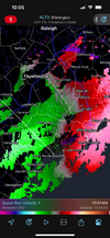
Here's the map for yesterday's quick-hitting clipper system where graupel mixed w/ snow east of the mountains of NC.

Looks like it wants to head back towards 8 for January. Come on you can do it.


 until Christmas


Had a 18F temp rise since midnight ahead of the Arctic front, was 38 now 56.
Sent from my iPhone using Tapatalk


 beechmtn.com
Just won’t having any staying power.This is now only 114 hours out (Thursday evening) and the deeper trough trend is still continuing as of the 6Z GFS:
View attachment 178912
Due to this the colder temperature trend for Saturday AM is continuing through the 6Z GFS:
View attachment 178914
Interestingly, the ICON led the way with this look for this weekend. As you've posted, the GFS has been playing catch-up for days.This is now only 114 hours out (Thursday evening) and the deeper trough trend is still continuing as of the 6Z GFS:
View attachment 178912
Due to this the colder temperature trend for Saturday AM is continuing through the 6Z GFS:
View attachment 178914


There is NO big storm on the Euro or GFS models for this time period.EURO with a big Boxing Day CAD storm on this morning's run. I do like how the various OP runs sniff out some big changes back to cold in the post-Christmas week time frame. Just noise at this lead, of course, but a reminder that the ensemble torches have some contrarian members.
You should still be able to easily enjoy your Xmas dinner on the back deck outside …Latest GFS and Euro for Birmingham. These temps while still above normal in the longer range, are a far cry from what we had been seeing. The trend still seems to be much cooler than what the long rage is spitting out with the high temps.
View attachment 178920View attachment 178921
Sorry, EURO AIThere is NO big storm on the Euro or GFS models for this time period.


Latest GFS and Euro for Birmingham. These temps while still above normal in the longer range, are a far cry from what we had been seeing. The trend still seems to be much cooler than what the long rage is spitting out with the high temps.
View attachment 178920View attachment 178921


I thought that Cosgrove guy just said cold and phase 8 of MJO is hogwash???How are we supposed to trust the GFS in the fantasy range when it has been this far off for this coming Friday? In just 30 hours of runs for Friday AM, Birmingham has gone from an anomaly of +13C to -2C! That’s a 15C/27F drop just since yesterday’s 0Z GFS! (And this then translates E into all of the SE on Sat as I’ve been showing.)
View attachment 178927
I like to emphasize that the MJO is a tool for its tendencies and that there are exceptions. But when also considering that the early Dec phase 8 was colder than an average phase 8, these MJO forecasts don’t at all typically go together well with a very warm late Dec when looking at history meaning I’m still not yet betting heavily on the mildness:
EPS
View attachment 178923
GEFS
View attachment 178924
Yeh because it’s not gonna happen. Big week of changes ahead.The GFS is almost 70 degrees in South Dakota on Christmas Eve. This is beyond ridiculous at this point. Very hard to believe
That's a nice trend from the past few days!How are we supposed to trust the GFS in the fantasy range when it has been this far off for this coming Friday? In just 30 hours of runs for Friday AM, Birmingham has gone from an anomaly of +13C to -2C! That’s a 15C/27F drop just since yesterday’s 0Z GFS! (And this then translates E into all of the SE on Sat as I’ve been showing.)
View attachment 178927
I like to emphasize that the MJO is a tool for its tendencies and that there are exceptions. But when also considering that the early Dec phase 8 was colder than an average phase 8, these MJO forecasts don’t at all typically go together well with a very warm late Dec when looking at history meaning I’m still not yet betting heavily on the mildness:
EPS
View attachment 178923
GEFS
View attachment 178924
There is NO big storm on the Euro or GFS models for this time period.
That's a nice trend from the past few days!


Hopefully trends like this continue if we ever get the chance at a winter storm. It’d be nice to watch something trend more favorable and colder during a big event.1. That huge cooling is actually just over 1.25 days of runs! We’re looking at the potential of a massive fail of especially yesterday’s 0Z GFS inside 7 days.
2. For later in Dec, the GEFS NAO has trended negative the last 48 hours: look familiar?
Two days ago (12/12):
View attachment 178928
Today (12/14):
View attachment 178929


In essence, we still kicking the can down the road like Bruce likes to say lol. Keep us posted when things may turn for a better pattern configuration. I guess the good news is it's still only mid December. If we are still saying this a month from now, then that's a different storyAbout the only good news we have is that Canada looks to remain cold in this -WPO / -PNA pattern, so any hiccup in the wave pattern could add some interest. But I feel like the only thing that could enact real change is if Greenland Blocking were to go to town and bully the pattern, and with the aforementioned cold air in Canada being redirected south - hard to achieve, but not a crazy idea given the pattern at hand in the Atlantic and a stratosphere that is not hostile to blocking developing.
MJO 7-8-1-2 progression has typically been fruitful in Cool ENSO / La Nina, but this fast-moving tropical wave embedded within a psuedo MJO setup has been a pill, and there is no sign of help coming from Asia (+EAMT) with wave breaking from the Pac Jet occurring well to the west in the Pacific (-WPO / -PNA).