Brent
Member
Very localized looks to be rain otherwise

Not a bad look at all and even though the GEFS and EPS torch everyone, it has major support. That ridge right there has staying power. If we can get cold air on our side of the globe, that can drop the hammer.
Fv3 sucktasticGfs shows another southern slider for Christmas but fv3 not buying it.
Sent from my iPhone using Tapatalk
I’m still shoveling out from the 23” it gave me! I think it’s koochy map , even gave me 15!Fv3 sucktastic

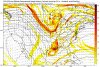
 Also @1300m @Storm5 @DarkKnight @Webberweather53 @Arcc do anyone of y'all think this has potential it almost looks like an upper level low passing through... I'm still learning guys
Look up top. Yes it is a pretty stout ULL. Temps look yuck, but ULL's are known for surprises.It may not be much to talk about but I been paying close attention for the days of the 14 and 15 for the past 3 days because the GFS and fv3-gfs been showing possible snow consistently since Saturday for places that hasn't seen it for the deep south... Here is the 6z GFS run from hours 108-126
View attachment 9025 Also @1300m @Storm5 @DarkKnight @Webberweather53 @Arcc do anyone of y'all think this has potential it almost looks like an upper level low passing through... I'm still learning guys

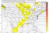
Looks like a severe weather threat.
Sent from my iPhone using Tapatalk
Instability is lacking greatly . Severe weather won’t be a big concern .
Time of the year. Instability can lack ... along got plenty shear ... if it trends more north. ... worth keeping eye on
Sent from my iPhone using Tapatalk

It may not be much to talk about but I been paying close attention for the days of the 14 and 15 for the past 3 days because the GFS and fv3-gfs been showing possible snow consistently since Saturday for places that hasn't seen it for the deep south... Here is the 6z GFS run from hours 108-126
View attachment 9025 Also @1300m @Storm5 @DarkKnight @Webberweather53 @Arcc do anyone of y'all think this has potential it almost looks like an upper level low passing through... I'm still learning guys
This system that you see coming in over CA is the one we're going to have to watch for (it's the system that's been showing up around Christmas Eve/day, although the timing will probably change.) The disturbance gets pushed down into Mexico, and it possibly can make it over the GOM (Gulf low) If the timing is right with the northern stream, this will set up the next *possible* winter event. We'll have to see what the northern stream will do and this disurbance as this week goes on.
Gfs shows another southern slider for Christmas but fv3 not buying it.
Sent from my iPhone using Tapatalk
Get the ridge steeper and that is a huge phaser threat on that run. Those are always fun.
The issue right now is cutting off the Pacific firehose and getting some arctic air back in Canada.


This would do although I have t looked at the ensembles yet

Sent from my iPhone using Tapatalk


It's only 4 days away so I doubt it will change much in that short time frame. Right ?
It's only 4 days away so I doubt it will change much in that short time frame. Right ?
I think that's from additional snow today, I don't see any model showing any frozen precip for NC after this for the next 7-10 days except maybe the models.Only four days away. This might be a nice surprise. Has snow for 99% of NC.
Only four days away. This might be a nice surprise. Has snow for 99% of NC.


Sitting at 24 degrees here at 2pm !Not bad at all for 1:45 in the afternoon on a day in the 1st one-third of December ...
View attachment 9041


View attachment 9044
Looks like rain at the moment. Hopefully that will change.
Yea the low is in a perfect spot. Just gotta have some cold air to go with it. It would be a lot of people on here get a nice snowstorm.Taking a look at the teleconnections, for now, the PNA is projected to remain slightly positive, could spike more positively as December 20th (or so comes around)
The cold will "relax" some, but by the looks of the AO, it could be around netrual to a neg. AO by the time that possible Gulf low comes around.
If there will be a Gulf low, that brings snow, the track needs to start northwest of the Yucatan Peninsula (about central GOM) and track through central FL, up the east coast - a text book Miller A. No warm noses! We'll need to really pay attention to those heights as well. I'm excited for this time period.

It's nice to have a December that actually feels like a winter month. Three years ago you could add 30 degrees to that in the eastern half of the US and it would probably be fairly accurate.Not bad at all for 1:45 in the afternoon on a day in the 1st one-third of December ...
View attachment 9041