BHS1975
Member
I was talking about the 60s. Lets gets some warmth
Sent from my SM-G955U using Tapatalk
Bitter? Lol
Sent from my iPhone using Tapatalk
I was talking about the 60s. Lets gets some warmth
Sent from my SM-G955U using Tapatalk

That cold push north of it should help a lot more, looks better at 384 then this past rainstorm.
This would be nice. Unfortunately it’s hr. 384...
Sent from my iPhone using Tapatalk
63 and rain beats 33 and rainI know, again I say "why"? We don't want warmth this time of year, leave that for the rest.

And it won’t break pocketbook as bad on the heat bill. Lol63 and rain beats 33 and rain
Sent from my SM-G955U using Tapatalk
This would be nice. Unfortunately it’s hr. 384...
Sent from my iPhone using Tapatalk


Yes indeed, that is a nice look setting up. The 12z FV3 has the same storm, but it puts it way north.
This would be nice. Unfortunately it’s hr. 384...
Sent from my iPhone using Tapatalk
Yeah right, I never need a break from winter weather!After this storm, I think we all need a break. I'm sure we will be rockin again in about a month.
")
At least let me get my foot of snow first. In a few days we all will be right back to tracking fantasy storms and staying up way to late to watch the next runs.Yeah right, I never need a break from winter weather!
Models continue to try and break that western ridge down in the long range to no avail. Don’t be surprised if we’re tracking another storm towards the beginning of the new year. Active STJ and plenty of cold air hanging out to our north. You heard it here first

Needs to trend colder. Wish there was a big high pressure just to north
I guess what I meant. That snow needs to drop into the upstate.Lol you can’t be serious look at the amount of cold on our side of the globe . This is fantasy land of course and has zero chance of verifying . But we are starting to final see signs of a much colder pattern ahead
Sent from my iPhone using Tapatalk
I guess what I meant. That snow needs to drop into the upstate.


Yes it is ... in some places ... LOLThe 850 isn’t that bad for a fantasy storm that is 384 hrs away
Sent from my iPhone using Tapatalk
Yes it is ... in some places ... LOL
Just be cool to see a white ChristmasThe 850 isn’t that bad for a fantasy storm that is 384 hrs away
Sent from my iPhone using Tapatalk
Even way out in voodoo land it still appears to look like rain chasing cold especially for areas in southern AL and MS. We all know how well that ends in the Southeast.My Alabama peeps lets do Christmas 2010 all over again lmao
Sent from my iPhone using Tapatalk
Please ...Ok we should change the grand prize trip to the Swiss Alps and send you and Larry.
Sent from my iPhone using Tapatalk
Definitely something to watch!!!My Alabama peeps lets do Christmas 2010 all over again lmao
Sent from my iPhone using Tapatalk
Yea!!! Best Christmas EVER!! And probably best winter 10-11. Think most of north Alabama ended up with about 20 inches total for the storms that year.My Alabama peeps lets do Christmas 2010 all over again lmao
Sent from my iPhone using Tapatalk
And Georgia peeps! Christmas gift from mother nature.My Alabama peeps lets do Christmas 2010 all over again lmao
Sent from my iPhone using Tapatalk
That track looks familiar too.And Georgia peeps! Christmas gift from mother nature.
Baby steps, Phil..baby stepsYes it is ... in some places ... LOL
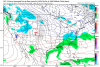
There may not be a Christmas storm. But that week of Christmas maybe the gfs is just simply telling us. That’s the week to at least watch.If you thought your Christmas snow chances were bad, you can assure they are even worse now that the GFS is showing a storm at hr384
If you thought your Christmas snow chances were bad, you can assure they are even worse now that the GFS is showing a storm at hr384
View attachment 9017
I rarely post but have been following for a while. Can someone help me understand what this graphic means? Been following some of the polar vortex guys on Twitter. Thanks in advance. I learn so much from this forum.
8 inches near Abilene on the snow map!