Lost in the potential big dog is the fact that we still could see a few token flakes Wed am....
-
Hello, please take a minute to check out our awesome content, contributed by the wonderful members of our community. We hope you'll add your own thoughts and opinions by making a free account!
You are using an out of date browser. It may not display this or other websites correctly.
You should upgrade or use an alternative browser.
You should upgrade or use an alternative browser.
Storm5
Member
Yeah supposed December thaw looks extremely short lived
Sent from my iPhone using Tapatalk
Sent from my iPhone using Tapatalk
Models have brought back the potential for a week clipper to give central NC a chance at some novelty flakes tomorrow morning. No accumulation but it will be cool if I get a nice early flurry!
All in... LolModels have brought back the potential for a week clipper to give central NC a chance at some novelty flakes tomorrow morning. No accumulation but it will be cool if I get a nice early flurry!

olhausen
Member
Models look to have done a nice job from last week forecasting today’s snow.


I woke up to snow showers and pellets this morning making this the 4th day I’ve seen snow fall from the sky already this winter. Never has this happened this early in my 12 years of living in northern Tennessee. By this week next time it could easily be 7-8 days of winter precipitation falling before mid December! Looks like tonight might be a nice little event also.

Sent from my iPad using Tapatalk
Storm5
Member
ArCC your boy is back with a different message today lol

Sent from my iPhone using Tapatalk

Sent from my iPhone using Tapatalk
Maybe that’s why Glenn Burns thinks January is going to be a very cold month.ArCC your boy is back with a different message today lol
Sent from my iPhone using Tapatalk
ArCC your boy is back with a different message today lol
Sent from my iPhone using Tapatalk
Oh good grief, he has passed the plane of JB and is getting close to Kevin Martin.
All joking aside, I hope he is right and it brings lots of snow. But Ive been waiting for him to be right for years now.
Brent
Member
I'll believe it when I see it but it would nice to verify for once 
Euro and EPS say the 13-14th may be our next possible threat.
I have snow flurries this morning, over performing clipper inbound haha
Sent from my SM-G950U using Tapatalk
Sent from my SM-G950U using Tapatalk
Last edited:
Wish I was at the house, returns up that way don't look too shabby.... I mean there were barely any returns when I saw flurries as I was leaving for work so there may be some legit snow showers up there now
edit: the wife just text and said light snow in Roanoke Rapids #winning
edit: the wife just text and said light snow in Roanoke Rapids #winning
Last edited:
Storm5
Member
Most likely won’t be this month but the amount of southern stream systems on the gfs is amazing . Maybe just maybe we time everything up next month and get a nice one
Sent from my iPhone using Tapatalk
Sent from my iPhone using Tapatalk
pcbjr
Member
Absolutely beautiful ... enjoy it while it lasts ...

Just had a short flurry in Durham. NWS RAH is getting similar reports around the Triangle
Some graupel in Roanoke Rapids per pic the wife just sent meJust had a short flurry in Durham. NWS RAH is getting similar reports around the Triangle
Sent from my SM-G950U using Tapatalk
olhausen
Member
Nice! Last night around 1am the radar turned yellow right over my area and dropped a dusting in 10 minuets with very heavy snow and 34 degrees. Ended with a tenth of an inch but would have had closer to an inch as snow flurries flew all night but didn’t hit freezing til 5am. December snow is bonus snow no matter how much in my book.Some graupel in Roanoke Rapids per pic the wife just sent me
Sent from my SM-G950U using Tapatalk
Looks like another quick burst of snow possible tomorrow. Maybe a quick 1/2-1" ! We are laying down snow cover here so you guys to the south will be colder !
Kylo
Member
I guess so much for the warmup. This is seasonal at best. If EPS is correct the east/se will be solidly BN for December.

NWMSGuy
Member
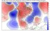
Is that another wave moving through southern CA at day 10 on the EURO?
packfan98
Moderator
Got my first flakes of the season today! More this weekend. #winning
I did not see any flakes in Raleigh today, but at least this December isn't a torch with days in the 60s and 70s every day!
Brent
Member
I did not see any flakes in Raleigh today, but at least this December isn't a torch with days in the 60s and 70s every day!
so true, we've had 8 freezes already this season, last year we didn't have our first til 2 days from now...
###CongratsGot my first flakes of the season today! More this weekend. #winning
Just as good as winning a prize on here. Lol
NoSnowATL
Member
So is there anything on the horizon?
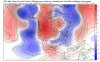
Still watch the period around the 14th. Nothing there yet, but seeing the GEFS and to an extent the EPS pumping the western ridge and dropping down energy. Definitely would favor the Carolinas again if it ends up digging enough. Everything still looks transient right now, so timing would have to be perfect. One thing is for certain both ensembles are showing a power house Aleutian low getting going.
Attachments
Last edited:
Incredible thick frost this a.m. cold as hell too
GeorgiaGirl
Member
We had frost so thick here there was still ice on the heat pump at about 10:30, maybe even later.
We barely broke 40F yesterday and I woke up to 23F this morning, hopefully it continues!
There's time for this to trend south....

The GFS has some backside snow this morning on December 14.

I went all in on this system and be lucky to get a few token flurries. I am ready for a break. LolThere's time for this to trend south....
Let the games begin!!!
I also be glad when it gets towards the end of the month. We will be more favorable climatology.
NoSnowATL
Member
Let’s just please not start a thread until we are 48hrs out.I went all in on this system and be lucky to get a few token flurries. I am ready for a break. Lol
Let the games begin!!!
I also be glad when it gets towards the end of the month. We will be more favorable climatology.
Storm5
Member
The ARCC storm lives

Sent from my iPhone using Tapatalk

Sent from my iPhone using Tapatalk
RollTide18
Member
Normally those who miss out on a big storm get a big storm not too far in the future.
Why ??? Then you miss out on all the heartbreaks and let down. That’s the best part. LolLet’s just please not start a thread until we are 48hrs out.
That'll end up near Bangor come verification timeThere's time for this to trend south....
Sent from my SM-G955U using Tapatalk
NoSnowATL
Member
Mr. Burns WSB in Atlanta said we might have a set up like this storm in a week? Said this will be a active Winter pattern. I’m just not used to him saying stuff like this.
What happened to the Mid December warmup ?Mr. Burns WSB in Atlanta said we might have a set up like this storm in a week? Said this will be a active Winter pattern. I’m just not used to him saying stuff like this.