Z
Zander98al
Guest
Might be a spin up in this area. Shear is increasing as it gets dark out. And there's already around 1000-1500 cape in that area. A lot of those cells are already spinning just not tight.


@Arcc what do you think of tomorrow nights event? Overproducer or dud lol?
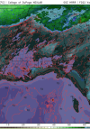
Much better directional shear in that top image.Update on tommorow. HRRR is doubling down on a more volatile setup. Cape now reaching around 2000 and over in central Alabama. Shear is looking a good bit better. With the surface low being more defined now than previously thought. A enchanced area is needed soon. View attachment 99589View attachment 99590View attachment 99591
What makes me nervous is all the simulated radar showing tons of isolated kidney beans. I'm afraid it'll turn into a big event very quickly. And not many people will get much warning.Honestly, normally I would say a slight risk with this setup would suffice, but on the other hand the over producing event earlier this month has me spooked. Usually when setups over produce, they continue to over produce. This setup is giving me vibes of a setup in either February or March in 2019 when I didn’t think much of that little event which turned out to be a supercell fest. While thankfully the tornadoes were on the weaker side, one tracked within a half mile of my house.
This event wensday 29th, shouldnt be too cluttered actually, (the new years one might be). There's a lot of dry air aloft. And not a strong cold front or forcing to get a bunch of precip going. This kinda reminds me of pop up summer showers. But with more dry air, and a bit more forcing lol.I'm still seeing a cluttered mess down towards Birmingham and points south, which is a positive for the northern parts of Alabama. This seems to be the new common for these setups. Crap part is you never know until the day of, if it comes to fruition. If there is no development to the south, well... the north suffers the consequences, but we've been saved time and time again by it. Hopefully it can rain itself out for the folks to the south and spare the damage and loss of life.
Sent from my Armor 9 using Tapatalk
The interesting thing is. HRRR has shown some decent rotating updrafts along a boundary into Tennessee and Alabama. That may be the best axis for moisture and shear combo, but less of a renegade cell threat. Two main threat areas imo, the boundary to the north with less instability but a bit more shear and then to the immediate south with pop up confluence cells.This event wensday 29th, shouldnt be too cluttered actually, (the new years one might be). There's a lot of dry air aloft. And not a strong cold front or forcing to get a bunch of precip going. This kinda reminds me of pop up summer showers. But with more dry air, and a bit more forcing lol.


We got to get some sort of ice in winter timeThat’s a solid setup for Nc in December, especially for hail/damaging winds, a April look View attachment 99598View attachment 99599View attachment 99597View attachment 99600View attachment 99601
I’m not sure how much stock to put into this, but this is interesting.
I’m not sure how much stock to put into this, but this is interesting.
I’m not sure how much stock to put into this, but this is interesting.
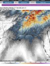
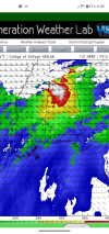
Looks like that stupid thing I was talking about yesterday is coming to fruition. A sig tornado area needs to be put in on north Alabama. Updraft helicity has really taken off over the northern section of Alabama. Things may start rolling a few hours early in north Alabama as well.That is concerning; it’s been pretty decent in the past. Looking through the WRFs, the best instability and shear line up pretty well with that bullseye and to the SW as the low level jet cranks just after dark. If convection could sustain itself, there could be a few hours of really dangerous weather in that area with sbcape of 1500-2000 and 0-1km helicity 250-300.
 my hopes for southern clutter has all but diminished with faster progression. Damn it.... Sure was hopeful. Still a chance but most southern activity is being booted to the east rapidly, leaving little to no blocking. Not looking good.
One thing to watch for is to see if the trend from last year continues with the threat verifying farther south than the models suggest.We may have a mini tornado spree in north Alabama today ?. Strongest tornado potential through the afternoon appears to be around a boundary in north Alabama


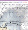
Meso low forms over MS and tracks into AL significantly backing low level winds.Probably a nasty hodo in that north Alabama region. SRH helicity in that region is screaming tornado threat. HRRR is starting to try and conjeal a semi convective line. But I doubt that will happen . The backing of the winds in north Alabama is phenomenal. 1000 cape will definetly suffice for a winter event. It may even push into 1500 capeView attachment 99621View attachment 99622View attachment 99623

Id be shocked at this point if a hatched area isn't added over north Alabama. Don't you just love mesoscale features lol..Meso low forms over MS and tracks into AL significantly backing low level winds.
View attachment 99625


 in northern Alabama.