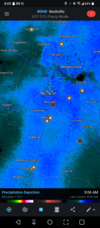
• Hello, please take a minute to check out our awesome content, contributed by the wonderful members of our community. We hope you'll add your own thoughts and opinions by making a free account!

Wintry December 23-26 2022 Winter Weather and Cold

I remember air masses this cold living in Miz-zour-rah in the mid-90's and back in Bama in the early 's 80's and you will literally get flurries that are so light (in this kind of air mass) it looks like diamonds sparkling in the air, even with partly cloudy skies. It would take about a year for them to add up to anything measurable but if you want to see flurries and that's your bar, you will likely see something post frontal passage.

Now for the kiddos and with temps in the single digits, go buy them some bubbles when the wind dies down. They look like glass when they freeze then shatter when they land. Cheap fun on a very cold day.
 
FFC went very conservative on temps, as usual. Probably 10 degrees higher than what is going to happen tonight and tomorrow???? Also one of the WORST AFD's I have ever seen ,especially with this cold coming...
 
Last edited:
FFC went very conservative on temps, as usual. Probably 10 degrees higher than what is going to happen tonight and tomorrow???? Also one of the WORST AFD's I have ever seen ,especially with this cold coming...
It looked fine to me and accurately reflects the expected conditions. It's not going to be in the single digits Friday morning and 16 to 19 looks about right for 7 am Friday in Atlanta.
 
Should I be putting any stock into the HRRR? It claims it’s going to be 45F here at 1pm on Saturday. NWS has a forecast high of 60F.
 
I see GSP has indeed adjusted some, AFD now indicates WCs of down to -10 outside the mountains instead of -5. The point a click for me also shows 7 now instead of 11.

00
FXUS62 KGSP 221942
AFDGSP

Area Forecast Discussion
National Weather Service Greenville-Spartanburg SC
242 PM EST Thu Dec 22 2022

.SYNOPSIS...
A band of precipitation associated with the arctic front will sweep
through the area tonight with rain changing over to a brief period
of snow across the mountains and foothills along/north of I-40.
Dangerously cold air will quickly spill into the area by Friday
morning with gusty winds and subzero wind chills. Temperatures will
remain below freezing for most locations through Sunday morning
before gradual warming takes place very late this weekend into next
week with dry weather continuing.

&&

.NEAR TERM /THROUGH FRIDAY/...
Cloud cover will remain high across the non/mtns this afternoon and
help keep temps below normal. Across the mtns, clouds have broken up
with dry air adv from the west and temps are running a little warmer
than fcst/d.

Expect all areas to cloud up this evening ahead of a dynamic arctic
cold front progged to reach the wrn NC mtns aft 08z. This front will
bring a tight and lowering temp gradient with enuf moisture to
instigate snow showers across the NC mtns. There may be a brief
period of sleet at onset, but the entire column goes below zero very
quickly and transitions to all snow. Not expecting too much accum,
likely on the order of 1 to possibly 3 inches mainly affecting
elevations abv 35000 feet. An advisory should not be needed and will
handle with an HWO mention for now.

The front will drop temps quickly by 14z across the NC mtns, abt 40
degrees to the single digits and the -5 F to -10 F range over the
higher elevations. Temps will also drop to the lower 20s across the
non/mtns by daybreak and then continue to drop into the upper teens
by the later afternoon. With very good llvl CAA, descending and high
momentum air will be forced to the surface and create very strong
gusts, especially across the nrn NC mtns where damaging gusts around
60 mph can be expected throughout most of the day Fri. A High Wind
Warning has been issued there. Elsewhere, a Wind Advisory will be in
place into early Sat.

With the combination of unusually cold air and strong winds, wind
chill values will drop dramatically across the mountains with
readings abv 3500 feet dropping into the -20 F to
-30 F range and even lower at places like Grandfather Mtn and Mt
Mitchell. Thus, a wind chill warning has been issued at elevations
abv 3500 feet into Fri night. Elsewhere, solid wind chill advisory
conditions will develop, meaning -10 F to -20 F across the mtn
valleys and 0 F to -10 F values outside the mtns into Sat. This is a
good time to make sure exposed pipes are protected and contingency
plans are made for potential power outages or dead car batteries,
such as ways to keep warm with layered clothing and ensuring current
contacts for possible assistance.

&&

.SHORT TERM /FRIDAY NIGHT THROUGH SUNDAY/...
As of 200 PM Thursday: Potentially record breaking wind chill
values will be in store Friday night as a brutal cold arctic airmass
settles in behind an arctic cold front that sweeps through the area
early Friday. A deep stacked low centered over the Great Lakes
region will keep very cold thicknesses over the region through
much of the short-term. Very strong CAA will filter in Friday
into Saturday and allow for very low wind chill values overnight
Friday as a Wind Chill Advisory has been issued for for locations
below 3500` feet in the mountains and across the Piedmont as wind
chill values range from 0F to -10F degrees. A Wind Chill Warning
has been issued for locations above 3500` in the mountains with
values ranging from -20F to -40F degrees. With 850mb temperatures
between -15C to -25C degrees, expect actual temperatures to drop
like a rock with single digits possible across most locations in
the Piedmont and subzero values across the High Country, so record
lows will obviously be in jeopardy.

Temperatures tread slightly warmer for Saturday as the axis of the
stacked upper low slips east of the area. Very cold thicknesses
will still be in place, while the leading edge of a stout surface
high (~1040+mb) works its way into the CFWA, while being centered
over the Great Plains. In this case, expect for highs to remain
below freezing for the most locations with teens and twenties in
the mountains, but winds will gradually subside outside of the
mountains on Saturday. Pressure gradient remains relatively tight
over the mountains through Saturday night. As a result, another
Wind Chill Advisory may be needed, especially for elevations above
3500`. Thicknesses gradually rebound on Sunday as the stacked
upper low lifts into Atlantic Canada and surface high builds in
over the Lower MS Valley and Deep South. Expect temperatures to
"rebound", but values will remain 15 to 20 degrees below normal
under mostly sunny skies.
 
Back
Top