Flotown
Member
that is an i teresting look,and wouldnt take much to be a bigger deal...IMO..I AGREE ,OUT TO SEA...AGAIN JUST MY OPINIONThis bomb actually has some legs but I bet it ends up ots
that is an i teresting look,and wouldnt take much to be a bigger deal...IMO..I AGREE ,OUT TO SEA...AGAIN JUST MY OPINIONThis bomb actually has some legs but I bet it ends up ots
Watched a video today from Ryan Hall Yall and he showed a Euro run showing us potentially getting backend snow.
Just from my life experience, it's rare to see snow before the first of the year in Upstate SC.Expecting anything in December (specifically anything before Christmas) during an El Nino was fools gold. This looks to exactly like what December was expected to be all along.
Yep. Even if we get a Aleutian low/+PNA, it wouldn’t deliver adequate cold, because while we may not bear the brunt of the +anoms, northern tier/Canada will, even Alaska/NW territories are gonna be on fire relative to average, the snow means for the NW territories on ens means are absolutely pitiful.That would do it. We have to get cross polar to get cold back over here quick. We can't sustain a decent pattern long enough to get homegrown cold in Canada before the Pac fire hoses it out. Seems like that's been the theme for years now. But even the -EPO seems to be poorly tilted and dumps in the west anymore.
With the Pacific jet getting strong next week, I wouldn’t be shocked to see modeled temperatures start to rise starting late next week and we end up with a lot of 60s the week leading up to ChristmasAfter this weekend storm and a couple nights below freezing at the start of the week it looks like mid 30s at night and mid 50s for highs maybe right up through Christmas. At least it's not 2015 again. Unless we manage to find a way to burn the last week of the month we may escape with just +1 or +2 for the month.
Same in Ga except Gainesville north.Just from my life experience, it's rare to see snow before the first of the year in Upstate SC.
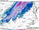
It's a very dynamic storm. I definitely could see a stripe from NC/TN mountains up through the western parts of Virginia, a good bit of WV into Maryland. The Mid-Atlantic crew at americanwx are getting stoked for at least something to talk about.Please discuss accordingly


Deform band at that… ?


Gotta cook before you freeze. Go ahead and get this outta the way before winter.
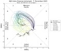
First NAMing of the young season. 6Z backed off quite a bit though. I still have 1/2 an eye on day 8-9 too but the Euro is just does not have any cold air around.Please discuss accordingly


Cutoff at the Triangle. Seems legit.
At your part of the triangle. Orange and Durham does okay.Cutoff at the Triangle. Seems legit.
Should of said cutoff at Wake. That's even more legit.At your part of the triangle. Orange and Durham does okay.
Snow weenies would lose their minds in the Mid-Atlantic if that verified.View attachment 138432
HRDPS on board


Yeah that's bad news. Hate to see that. The usual suspects.People in west and middle Tennessee be alert! I wasn’t expecting to see large confirmed extremely dangerous tornado wording today.View attachment 138440View attachment 138441
Not bad. Isn't that about average for there?50s for highs
.png")
Yeah, my number one hope is not to have a warm/muggy Christmas.I like snow as much as any but I’ll take frosty mornings and upper 50s this time of year. It could be worse as we’ve seen the last 10 years.
Too many of those on the East Coast last few years. Except last year of course. I'd be fine with upper 30's/low 40's and upper teens low 20's at night.Yeah, my number one hope is not to have a warm/muggy Christmas.

Even showing snow in the CLT metro prior to daybreak