• Hello, please take a minute to check out our awesome content, contributed by the wonderful members of our community. We hope you'll add your own thoughts and opinions by making a free account!

Pattern December 2023

My chance for rain to snow down here in the valley seems to be getting away from me. cool enough soundings are more like midnight now vs 10 PM yesterday. Floyd and Montgomery should have a much better chance as always. @LukeBarrette and @SWVAwxfan good luck over there.
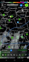
I’m driving somewhere with another Met student and we are trying to decide. Models are all over the place
 
I unfortunately can’t get behind there being snow for the charlotte area with the backside band, normally precipitation moves out faster and cold moves in slower, betting on nothing here
Yeah… I was very surprised to see GSP put it in the forecast grids… they have removed it this morning. Maybe someone new to the region was putting together forecasts yesterday
 
Merry Christmas!
03f0a9071b7e1a010e4a689618bd579e.jpg


Sent from my iPhone using Tapatalk
 
What kind of weather do you want???...LOL. HRRR says the Winter Storm Warning is warranted for the Blue Ridge.;)
lwx.pngys IMG_2276.png.d66c0e2b5d1d8ede339200f1a3234e7d.png
 
Mention of snow is back in my point and click forecast from GSP, for after midnight tonight. Guess I might check the radar before hitting the sack to see how much moisture is still left out there. Might stay up for a while if it looks like there is a chance.
 
This is why many of the smaller scale indexes, such as the MEI, that was mentioned, don’t matter, this December was basically set in stone to eventually hit the crapper with the strength of the Nino this past fall, and is following the progression you would typically see, as it normally would. The more south you go, likely the less intense the anoms will be. But this, is a super Nino like pattern right here. The euro weeklies and gefs ext have looked much less favorable for early January too, probably given how intense this extension is and how much arctic air, that will be driven out of NA. If you’re looking for any hope, you don’t actually want tropical forcing to enter the pacific (8) in tandem with +AAM. because that phase favors an extended pacific jet. After Christmas eyes need to be set on the progression of the pattern in Asia, and the strat pattern. The pacific jet will eventually back off, but it might take a lot of time. 8E084C54-06CC-4BE6-888F-BA211608D9FE.png82DCDF8C-19A9-4270-AE57-4AAF374C5743.png5EDA4423-A6D5-4609-BEDC-347F75C564F7.png
 
40 here
 

Attachments

  • 20231210_165133.jpg
    20231210_165133.jpg
    4.1 MB · Views: 24
  • Screenshot_20231210_165223_RadarOmega.jpg
    Screenshot_20231210_165223_RadarOmega.jpg
    1.2 MB · Views: 21
Back
Top