some grassy surfaces turning a little white, but overall.. meh. This one of those just enjoy watching it fall and mostly melt events. Can't complain otherwise.
-
Hello, please take a minute to check out our awesome content, contributed by the wonderful members of our community. We hope you'll add your own thoughts and opinions by making a free account!
You are using an out of date browser. It may not display this or other websites correctly.
You should upgrade or use an alternative browser.
You should upgrade or use an alternative browser.
Wintry December 10-11th winter potential
- Thread starter SD
- Start date
avlsnow
Member
Looks like the nam is still underestimating the snowfall

GeorgiaGirl
Member
Beautiful (Huntsville):
Huntsville is such a pretty area. Probably my favorite part of Alabama, and its even more beautiful in the snow !
Parts of North GA are also under a Winter Weather Advisory.
Usmeagle2005
Member
campamy
Member
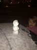
Pouring snow here for the past 15 minutes or so. Everything is white now! Starting to stick on thesidewalk. View attachment 27738View attachment 27738
Attachments
Glad people are seeing some snow that's awesome! Congrats!
Sent from my SM-G975U using Tapatalk
Sent from my SM-G975U using Tapatalk
ForsythSnow
Moderator
For Dawson county north, they're saying 0.1 - 0.5" between 1k and 2k feet, and up to an inch above that. I wonder if me being so close to the border and being at 1.2k feet could mean I could see something. Moisture looks way better than was was expected and I see a good flow coming up that should be here in a couple of hours.Parts of North GA are also under a Winter Weather Advisory.
NBAcentel
Member
Third year in a row with some sort of winter weather in the SE around this time in DecemberGlad people are seeing some snow that's awesome! Congrats!
Sent from my SM-G975U using Tapatalk
December has become quite the wintry month.Third year in a row with some sort of winter weather in the SE around this time in December
NorthGaWinter4
Member
Was thinking the same. Maybe we can squeak out a dustingFor Dawson county north, they're saying 0.1 - 0.5" between 1k and 2k feet, and up to an inch above that. I wonder if me being so close to the border and being at 1.2k feet could mean I could see something. Moisture looks way better than was was expected and I see a good flow coming up that should be here in a couple of hours.
Storm5
Member
I’m staying up till this is over , looking forward to adding another fail to 2019
Sent from my iPhone using Tapatalk
Sent from my iPhone using Tapatalk
If you look back since 2000 we have done quite well in early DecemberThird year in a row with some sort of winter weather in the SE around this time in December
Sent from my SM-G975U using Tapatalk
Storm5
Member
Dry air is about to start eating away at the back edge
Sent from my iPhone using Tapatalk
Sent from my iPhone using Tapatalk
But was Bham ever predicted to get anything from this?I’m staying up till this is over , looking forward to adding another fail to 2019
Sent from my iPhone using Tapatalk
Storm5
Member
But was Bham ever predicted to get anything from this?
No not really . A flake is a win
Sent from my iPhone using Tapatalk
Actually it over performed here just south of Decatur. Have close to 2 inches on ground. Here is last picture in daylight.I’m staying up till this is over , looking forward to adding another fail to 2019
Sent from my iPhone using Tapatalk

it's over in Chattanooga. Too warm to stick, would have been a one incher or so had temps been a little better. Going to call this a fail really.
IMBY

This was a cool event today!!!
#caughtonNestCam. https://video.nest.com/clip/6e2028f1cf594a3ea65d90ebbde4c45e.mp4
one of my cameras.
one of my cameras.

Storm5
Member
I’ve got sleet finally
Sent from my iPhone using Tapatalk
Sent from my iPhone using Tapatalk
Hopefully about to see some flakes. #winningI’ve got sleet finally
Sent from my iPhone using Tapatalk
very warm snow/sleet event.. did not get below 33 at the airport for the entire duration of the precip.
very warm snow/sleet event.. did not get below 33 at the airport for the entire duration of the precip.
Definite overperformer in terms of duration of frozen precip, 8 hours worth. Granted it was generally light and didn't accumulate to much but that was expected. Anything besides flurries before mid-December is a win in my book.
Fountainguy97
Member
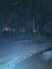
Couple of quick pictures before bed. Stuck fast to roads. Schools closed very fast.
should freeze up pretty hard overnight and still a couple hours left of snow


should freeze up pretty hard overnight and still a couple hours left of snow
true, but it's our turn to score on a dec storm for once.. instead of spots south of here.Definite overperformer in terms of duration of frozen precip, 8 hours worth. Granted it was generally light and didn't accumulate to much but that was expected. Anything besides flurries before mid-December is a win in my book.
")
Wxfan
Member
Heavy sleet.
Won’t be longHeavy sleet.
Flipped back to a mix unbelievable.I was at a mix then all sleet now I’m back to mixing. It’s fighting but this band is flying and shrinking
Sent from my iPhone using Tapatalk
And it’s over lol...Next
accu35
Member
I didn't get jack
Fountainguy97
Member
Ended with one inch on the board this morning!

Posting a couple of maps from the snow analysis site (NOHRSC) showing where snow fell yesterday. The 2nd map only shows areas that received an inch or more of snowfall.
Also here are the "official" NWS totals at the TAF sites where snow data is collected.
Huntsville, AL - 0.7"
Tri-Cities, TN - 0.4"
Chattanooga, TN - 0.3"
Knoxville, TN - 0.3"
Good appetizer, onto the next bigger better one.


Also here are the "official" NWS totals at the TAF sites where snow data is collected.
Huntsville, AL - 0.7"
Tri-Cities, TN - 0.4"
Chattanooga, TN - 0.3"
Knoxville, TN - 0.3"
Good appetizer, onto the next bigger better one.
olhausen
Member
Congrats to all those that saw snow yesterday! The dry air absolutely killed the Nashville and north areas yesterday unfortunately. The snow would have been over us for hours and would have easily eclipsed one inch if not more. I think dry slots are the worst because all the ingredients are there except for the snow not reaching the surface. It’s been a while since I can remember a dry slot like yesterday’s that basically blanked us except for a few early morning flurries.