WXinCanton
Member
NC Crush job!!

The clipper showing up a few days ago for Tues/Wed, vanished right?
We toss
This is the track we need for the most people on here to see a snowstorm. IMO I think we might very close to this.Atleast suppression isn’t showing up on GFS!

 Seen worse...
I agree, that is very a Euro/FV3 trackThis is the track we need for the most people on here to see a snowstorm. IMO I think we might very close to this.
View attachment 7991
This is the track we need for the most people on here to see a snowstorm. IMO I think we might very close to this.
View attachment 7991
its having some weird convective feedback issues over texas..
The new euro comes out around 7 correct? And I think the gfs has the system a bit to far north just my opinion
Lol I hear ya. I hoping to get something here also. I would love to fly my mavic pro drone and upload the videos/photos on here.Boy DarkKnight, if we actually manage to get there...I won't need to do anything streams wise or thinking about making a day trip drive (that I'm sure my parents will not be fans of) to see winter weather.
It's never easy is it ?Wouldn’t be a southeast storm without some model wars.
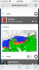
That's not the same low, that's the secondary low.View attachment 7992 Seen worse...
lol a rain/snow mix all the way to New Orleans ? Yeah i don't believe that. Toss it !View attachment 7995 View attachment 7995 Wedge and frozen gets DEEP into ATL metro, on 18z!!!
Why does this weather site show mix and all so far south but tidbits doesn’t?View attachment 7995 View attachment 7995 Wedge and frozen gets DEEP into ATL metro, on 18z!!!
Yea and the EURO and Control run does the same thing...transfers energy to the secondary low close to the Ga coast and it crawls along the coast from there. As 850s drop this puts back end snow across N Ga and places NEward.That's not the same low, that's the secondary low.

Also I meant to add. Either way this storm goes. North Carolina is going to be the big winner. They have the CAD to save them.This is the track we need for the most people on here to see a snowstorm. IMO I think we might very close to this.
View attachment 7991
Dont forget upstate SC.Also I meant to add. Either way this storm goes. North Carolina is going to be the big winner. They have the CAD to save them.
Why’s this map look so different from the tropical tidbits maps?View attachment 7995 View attachment 7995 Wedge and frozen gets DEEP into ATL metro, on 18z!!!
That map is way lower resolution. Look at the size of the pixels. IWhy’s this map look so different from the tropical tidbits maps?

 Yep, he did it! On his FB video! Said to be responsible, he had to show it , because we’d see it somewhere else! Lol
It's getting closer, come to papa.....
Closing in on 5 years, Shawn. Reel this one in.Keep in mind the "ptype maps" on weather nerds are more "gridded" and will show the potential precipitation type "IF" there was still ample moisture. It's not 100% set in stone by any means.
For example, you see all that orange in SC even to the coast? In theory that's showing a sleet and rain mix. It's a little confusing though..
It's getting closer, come to papa.....
Jon posted the breakdown of Fzrn/IP/SnowWouldn’t most of that end up as sleet in Raleigh?
Sent from my iPhone using Tapatalk
Meh, it’s gonna start as rain, that transition to anything frozen, can be painful to wait on and cut way down on snow/ice!Dont forget upstate SC.
Sent from my SM-G955U using Tapatalk
It's very close but keeps trending colder and this run was mostly snow, thermals appear to support that this run..... but it's Cen NC the warm nose is always lurkingWouldn’t most of that end up as sleet in Raleigh?
Sent from my iPhone using Tapatalk