The GFS seems too warm at the surface in ATL-AHN corridor when considering 850s of past storms. Typically 850s colder than +5C along with a strong wedge and widespread precip. has given them mainly ZR. Hmmm....warm bias problem here? I'm not buying temps nearly as warm as the GFS has it there.
-
Hello, please take a minute to check out our awesome content, contributed by the wonderful members of our community. We hope you'll add your own thoughts and opinions by making a free account!
You are using an out of date browser. It may not display this or other websites correctly.
You should upgrade or use an alternative browser.
You should upgrade or use an alternative browser.
Wintry Dec 8-10th Winter Storm
- Thread starter SimeonNC
- Start date
NBAcentel
Member
the thing im most encouraged by is that the soundings on the gfs have improved every run over the past 2 days or so. still expect a warm nose and sleet but it is a lot better than trending the other way.
Fountainguy97
Member
Guys look how warm the gfs is vs nam...
If nam is right...

If nam is right...
snowlover91
Member
The CMC is warm because it has more phasing sending the 850 low west of the apps with a transfer to NE NC hence all the warm air. This, while not a high possibility right now, is something that could definitely happen if our 5H wave slows down and/or phasing happens sooner.

GeorgiaGirl
Member
The GFS also seems to be eroding the HP too quickly.
Jon
Member
Warm nose for RDU definitely there on the 12z GFS...sleet (aka my avatar)Verbatim that would probably be a VERY heavy wet snow since the upper level temps are at or below 0C and only the last few hundred feet are above freezing. Realistically you'd probably be 33-34 at the surface IMO.
Attachments
Kylo
Member
GFS/UK are fairly close with keeping the NS energy separated from southern low. It's up in the Dakota's. The Euro/CMC are phasing quicker. Still 4 days out, we might not know for atleast a couple of more days, wouldn't be surprised to see the 18z GFS flip back to a warmer solution.

Last edited:
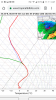
My gfs sounding at 18z sunday. Riding that fence between ripping snowstorm and miserable cold rain

Sent from my SM-G955U using Tapatalk

Sent from my SM-G955U using Tapatalk
That pesky warm nose goes all the way up to the triad for a time..Warm nose for RDU definitely there on the 12z GFS...sleet (aka my avatar)
I agree. Unless some better trends for the ULL we march on to the next one.Good run for NC. Should just about do it for most of GA/AL with the ULL not panning out. Still it’s a good thing that we had to watch this up to a few days out. Plenty of winter for other opportunities.
Sent from my iPhone using Tapatalk
That's almost identical to mine.... we are right on that fence, my eyes will be hurting looking at CC lolMy gfs sounding at 18z sunday. Riding that fence between ripping snowstorm and miserable cold rain
Sent from my SM-G955U using Tapatalk
snowlover91
Member
Warm nose for RDU definitely there on the 12z GFS...sleet (aka my avatar)
Yeah it changes to sleet at that point... but the sounding metwannabe posted would probably be a heavy wet snow sounding but very borderline. Going to be a tough dividing line that will bounce around a lot.
Kylo
Member
Past few runs of the GFS have "trended" and I use the word trended lightly to more separation. The NS low over HB plays a role too. Lot of moving parts.

You still have hope for the Midlands? We live in Hell, don't have Winter storms in Hell.Gfs is slower also.. this is definitely a no go for the Midlands of SC.
Jessy89
Member
Has the storm been sampled yet? I expect changes for better or worse at that time
accu35
Member
I believe 0z tonight?Has the storm been sampled yet? I expect changes for better or worse at that time
Jessy89
Member
I believe 0z tonight?[/QUOTE
Thanks that run will be crucial
Kylo
Member
Canadian past few runs have trended slower with the NS
LovingGulfLows
Member
- Joined
- Jan 5, 2017
- Messages
- 1,499
- Reaction score
- 4,100
Well according to Weathernerds.org, GFS is actually a ice/mix here in N GA during much of the precip.

Yeah man we are legit on the border. I bet we end up on the outside looking in. A 1-3 degree trend colder takes us from a snow to sleet to rain scenario with 1-2 inches to a big 4-8 inch snow to sleet storm.That's almost identical to mine.... we are right on that fence, my eyes will be hurting looking at CC lol
Sent from my SM-G955U using Tapatalk
Cary_Snow95
Member
Main takeaway from the 12z GFS for central NC in my eyes was the r/s line barely got over rdu that time. The previous runs had been flipping rdu to rain by 75-100 miles before
Snowflowxxl
Member
Do we know how accurate this is? It always shows better than what the models showWell according to Weathernerds.org, GFS is actually a ice/mix here in N GA during much of the precip.
MichaelJ
Member
This situation is a dual edged sword. If it ( low) slows down some, the CAD can be established better prior to precip, but conversely it might slow enough to allow the high to weaken and slide east. As usual, we are threading the needle here. Overall do not like the trends here especially outside the NW Triad, foothills and mountains and they have little wiggle room left as well IMO
LovingGulfLows
Member
- Joined
- Jan 5, 2017
- Messages
- 1,499
- Reaction score
- 4,100
Do we know how accurate this is? It always shows better than what the models show
Well it is using the models data, but it calculates the precip types differently than TT or Pivotal. Personally I think it's too generous.
I think it's very likely RDU/central NC will get a front-end thump of snow followed by a period of mixed precipitation. It's possible we may get some more snow or mixed precip from the backside of the system on Monday night. Accumulation here is highly uncertain depending on the temperature profiles: anything from no measurable snow to 6 or more inches is still on the table. I do think it is extremely likely we will get at least a brief period of winter precipitation, however.
I really don’t understand these maps. Can someone help? They look like fake news to meWell according to Weathernerds.org, GFS is actually a ice/mix here in N GA during much of the precip.
NWMSGuy
Member
Really liking the NAM at the moment for Northwest MS.
Like Snowflowxxl said it calculates the p-type differently.Yeah for WNCi
I really don’t understand these maps. Can someone help? They look like fake news to me
ATLwxfan
Member
Yeah for WNCi
I really don’t understand these maps. Can someone help? They look like fake news to me
Seriously we need a met to chime in on this. Delta?
Sent from my iPhone using Tapatalk
Storm5
Member
CMC has the Nam/Icon/Euro idea with backend energy little further west.
All we can really hope for are a few flurries. The trend is to not close that energy off and it’s further east each run . Neither of which are good . Thank god it’s early December and we have 2 1/2 months left of winter
Sent from my iPhone using Tapatalk
RollTide18
Member
All we can really hope for are a few flurries. The trend is to not close that energy off and it’s further east each run . Neither of which are good . Thank god it’s early December and we have 2 1/2 months left of winter
Sent from my iPhone using Tapatalk
Well if you want to look at it one way, we did get flurries last month so we’re ahead of schedule.
ForsythSnow
Moderator
3 days still and I had a feeling today would be bad on trends. I'm predicting a mass jumping after the euro and everyone coming back up by tomorrow at 12Z.
Idk who created this radar simulator, but it keeps showing up on here. It's showing a mix way to far South everytime. Would not believe this at all.Well according to Weathernerds.org, GFS is actually a ice/mix here in N GA during much of the precip.
NBAcentel
Member
Today has not even been that bad, 12z icon is better and 12z gfs improved, well for nc anyways, next the fv3, the ensembles, the euro
Chattownsnow
Member
yeah me too. I've seen these set ups play out the same for many years (been model watching and on the boards since 2008). The NAM is always our last hope and then they are dashed "almost" every single time. But every now and then it gets it right, most likely due to dumb luck lol.Really liking the NAM at the moment for Northwest MS.
I think the simulated radars are handling the CAD better. But, yeah I don't think the frozen precip. will be down that far south past ATL.Idk who created this radar simulator, but it keeps showing up on here. It's showing a mix way to far South everytime. Would not believe this at all.
snowlover91
Member
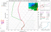
Yep it's definitely off. Here is an area in SC that it shows as a "mix" but the entire column is at or above 0C.I really don’t understand these maps. Can someone help? They look like fake news to me

Kylo
Member
I recall looking at the big snow event for Kansas City to Chicago a couple of weeks back and checked the GFS and Euro on which model did better. The GFS started to hone in on day 3 and Euro day 4, we are at that point today with the Euro. Going to give greatest weight to Euro/EPS todays runs on forward.