• Hello, please take a minute to check out our awesome content, contributed by the wonderful members of our community. We hope you'll add your own thoughts and opinions by making a free account!

Wintry Dec 8-10th Winter Storm

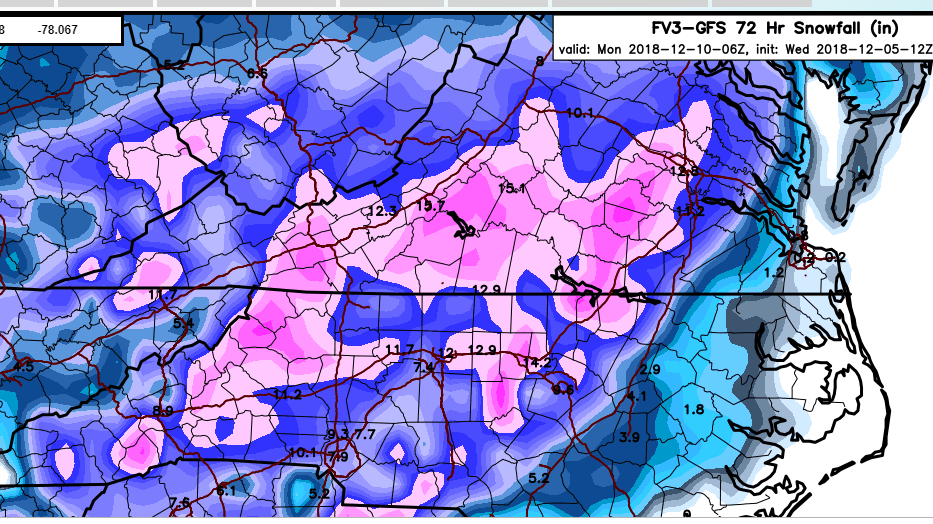
that's more than just something brief..that's sweet
I’m not cliff jumping my area was never in this to begin with . There might be a very quick front end window where NW Alabama could see a brief period of wintry mix but it’s quickly going to rain . Your best hope is light snow on the backside with the trailing energy


Sent from my iPhone using Tapatalk
47580833_566456417133366_8679900361416245248_n.png
 
Best gefs run so far in nc in my opinion
 

Attachments

  • Screenshot_20181205-121021.png
    Screenshot_20181205-121021.png
    274.4 KB · Views: 67
15D8850D-704F-4008-B9CA-64DA046E81F8.png 808271CF-021A-419A-8C6C-EA3E2C13207A.jpeg I know this is wish casting. If we could get the 850’s on this which we still have plenty of time. I think the back side of this thing could be a nice hit of snow for some with a main low being that far south. Kinda like the end of the nam was showing but just further west. I think where I have circle for the backside of the storm could deliver. But it is always thread the needle type of situation here.
 
When the storm transfers, it jacks up the thermals. If it was to remain a consolidated Miller A, upstairs would be a lot cleaner and a lot more straightforward. If you're outside the mountains and foothills, you are most likely going to mix for a time. The farther east you go, obviously, the more mixing you will do and the higher the likelihood you will get rain at some point.
.
a2936bddde5b94a49ba5ee2e16d3820d.gif


Sent from my SM-G950U using Tapatalk
 
View attachment 8454 View attachment 8455 I know this is wish casting. If we could get the 850’s on this which we still have plenty of time. I think the back side of this thing could be a nice hit of snow for some with a main low being that far south. Kinda like the end of the nam was showing but just further west. I think where I have circle for the backside of the storm could deliver. But it is always thread the needle type of situation here.
I think that is possible as well.
 
Even with a 1035 I'd think there'd be ice further south then it's showing. We'll have to see how the high res models handle that part of it.

(although I think it'd mostly just be down to the NE ATL suburbs)
 
GEFS mean increased for upstate SC


Sent from my iPhone using Tapatalk
 
GEFS...

snod.conus.png


Some with secondary energy that I'm sure is south, but I think if that energy works it'll probably be snow on top of snow for the guys that got the main event.
 
Even with a 1035 I'd think there'd be ice further south then it's showing. We'll have to see how the high res models handle that part of it.

(although I think it'd mostly just be down to the NE ATL suburbs)
What’s the main issue again ice? Heavy precipitation?
 
That mean of 10 inches will only be possible if a changeover to rain does not occur. I highly doubt we have constant frozen precip, it's likely going to be all rain or mix from late Sunday through Monday afternoon.
Agree, my hope that anything falls by mid-morning Sunday is sleet/snow. After that it will probably get washed out. Still, for early Dec that would be a big win.
 
I was taking a look over the 12z, 12km NAM. Nice to see those cold 850mb anomalies. 12km NAM is projecting actual 850 temps at or just above freezing. Surface temps. are at freezing in northern MS, just above freezing in northern AL, northern GA, upstate SC, some places are already at freezing in NC. This is when the precip is just starting to move in too. Once that precip starts falling, those temps will come down. It's going to get very interesting around here.
6ba5365fa434a9815e2026dd500eee9c.jpg
a0e7ca0e96a55ba3d969cc04bdec8e1b.jpg
What does this mean for NE Alabama? Just a snow fanatic wanting to learn more.
 
Back
Top